Lovely Banks is a northern suburb of Geelong, Victoria, Australia. Once an agricultural and rural area, the suburb is quickly developing into a residential area adjoining the Geelong suburbs of Bell Park, Corio and Norlane. At the 2016 census Lovely Banks had a population of 2,301.

North Shore is an industrial and residential suburb of Geelong, Victoria, Australia. The suburb overlooks Corio Bay. A small residential area is east of the North Shore railway station with a few neighbourhood shops.

Norlane is a northern suburb of Geelong, in Victoria, Australia. Norlane is bordered in the south by Cowies Creek, in the north by Cox Road, in the west by Thompson Road and in the east by Station Street. It is about 7 km from the Geelong central business district and approximately 70 km from the state capital, Melbourne. It is about one kilometre from the shore of Corio Bay. At the 2016 census, Norlane had a population of 8,306.
Bell Park is a residential suburb of Geelong, Victoria, Australia. It is located 6 km north-west of the Geelong city centre and is bordered to the north by Cowies Creek, to the east by Thompson Road, to the south by the Midland Highway and to the west by Anakie Road.

North Geelong is a suburb of Geelong in the Australian state of Victoria. The suburb was bypassed by traffic from Melbourne coming from the Princes Freeway by the creation of the Geelong Ring Road, which was complete in 2009. At the 2016 census, North Geelong had a population of 2,966.

Bell Post Hill is a residential suburb of Geelong, Victoria, Australia. At the 2016 census, Bell Post had a population of 4,919.

North Shore railway station is a regional railway station on the Warrnambool line, which is part of the Regional railway network. It serves the northern Geelong suburbs of North Shore and Norlane, in Victoria, Australia. North Shore station is a ground-level unstaffed station, featuring two side platforms. It opened on 15 April 1895, with the current station provided in 1991.
Eastern Beach is a popular swimming and recreation area in Geelong, Victoria on the shores of Corio Bay. Built during the 1930s in the Art Deco style, a shark proof sea bath is provided, as well as a children's swimming pool, kiosk, and dressing room pavilion. A number of Art Deco buildings in the area are listed on the Victorian Heritage Register.

Corio Oval was an Australian rules football ground, located in Geelong, Victoria, and used by the Geelong Football Club in the VFA and the VFL from 1878 to 1915, and 1917 to 1940. Sited in Eastern Park, the oval was served by trams from 1930 when the line was extended along Ryrie Street to the football ground.

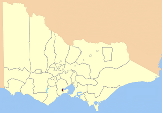
The City of Geelong was a local government area about 75 kilometres (47 mi) southwest of Melbourne, the state capital of Victoria, Australia. The city covered an area of 13.4 square kilometres (5.2 sq mi), and existed from 1849 until 1993.

The Geelong and Melbourne Railway Company was a railway company in Victoria, Australia. Alexander Thomson, a member of the Victorian Legislative Council, introduced and mentored a bill to incorporate the Geelong and Melbourne Railway Company. On 8 February 1853, the operation of Melbourne and Geelong Railway Company and Mount Alexander and Murray River Railway Company was approved by the Victoria Government. Thomson was one of the directors and presided at the first shareholder meeting. Work began at the Geelong end in 1854 but progress was slow due to a labour shortage caused by the Victorian gold rush, so the Victorian government hired out 100 prisoners to the company at a daily rate of five shillings each. They were housed in prison hulks moored in Corio Bay. English engineer and surveyor, Edward Snell, undertook the survey and design of the line, including a station and extensive workshops at Geelong, and a number of bluestone and timber bridges.

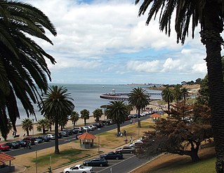
The Geelong Waterfront is a tourist and recreation area on the north facing shores of Corio Bay in Geelong, Australia. The area was once part of the Port of Geelong, falling into disuse before being redeveloped during the 1990s.
The City of Geelong West was a local government area about 5 kilometres (3 mi) west of the regional city of Geelong, Victoria, Australia. The city covered an area of 5.26 square kilometres (2.0 sq mi), and existed from 1875 until 1993.

The Shire of Corio was a local government area located between Geelong and Werribee, about 60 kilometres (37 mi) southwest of Melbourne, the state capital of Victoria, Australia. The shire, which included all of Geelong's northern suburbs, covered an area of 704.66 square kilometres (272.1 sq mi), and existed from 1861 until 1993.

Port Phillip, sometimes referred to as Port Phillip Bay, is a large bay in southern Victoria, Australia, 1,930 km2 in area, with a coastline length of 264 km (164 mi). The bay is extremely shallow for its size, but mostly navigable. The deepest portion is only 24 m (80 ft), and half the region is shallower than 8 m. Its volume is around 25 km3. The city of Melbourne is located at its northern end, near the mouth of the Yarra River.

Geelong East was an electoral district of the Legislative Assembly in the Australian state of Victoria from 1859 to 1985. It was located south of the city of Geelong, defined in the Victorian Electoral Act, 1858 as:
Commencing at the north-western angle of the town reserve of Geelong; thence by a line south to the River Barwon; thence westward and northwestward by the River Barwon to the western boundary of the reserve at the junction of the Moorabool and Barwon; thence east by the northern boundary of section 25, parish of Barrabool; thence south by the eastern boundaries of sections 25 and 11, and by part of the eastern boundary of section 7, all in the same parish; thence south-easterly by a curved line crossing the Waurn Chain of Ponds to the southern boundary of section 3, parish of Conewarre; thence east by the southern boundaries of sections 3 and 4 in the same parish; thence north-easterly by a curved line crossing the River Barwon to the south-eastern angle of section 11 in the parish of Moolap; thence by the eastern boundary of that section and a line north to the shores of Corio Bay; and thence by the shores of Corio Bay to the north-western angle of the town reserve, the commencing point aforesaid, including the remaining portion of the reserve at Point Henry.
Geelong West was an electoral district of the Legislative Assembly in the Australian state of Victoria from 1859 to 1985. It was located west of the city of Geelong, defined in the Victorian Electoral Act, 1858 as:
Bounded on the north and north-west by a line drawn at a distance of 2 miles from the north-western angle of the town reserve of Geelong, as a centre from the western shore of Corio Bay, near Cowie's Creek, to a road leading to the River Barwon; on the west by that road; on the south-west and south by the River Barwon; and on the east by the western boundary of the town reserve of Geelong and the shores of Corio Bay, including the reserve at the junction of the Barwon and Moorabool
The Electoral district of Geelong was one of the original sixteen electoral districts of the old unicameral Victorian Legislative Council of 1851 to 1856. Victoria being a colony in Australia at the time.
The Geelong Maritime Museum is a volunteer-run Community group or not-for-profit historical museum located at 'The Stables', Osborne House, Swinburn Street, North Geelong Victoria, Australia since 1993. The Museum was founded in about 1989, with ex Royal Navy Ldg. Tel, Robert Henry (Bob) Appleton OAM as the foundation Honorary Curator. The Museum collects and displays historic artefacts and documents related to the Maritime History of geelong and Victoria, and the history of the Victorian and Australian Navy's.
Cowies Creek Rail Bridge No. 1 is a bridge in Victoria, Australia, on the Geelong-Ballarat rail line in the outer Geelong suburb of Bell Post Hill. Constructed of bluestone in 1860 to cross both Cowies Creek and a roadway, the structure is listed in the Victorian Heritage Register.