Corio Bay

Last updated

Corio Bay
Corio bay 1927.jpg
Corio Bay, overlooking Geelong West, Drumcondra and North Geelong in 1927.
Australia Victoria relief location map.jpg
Red pog.svg
Corio Bay
Location in Victoria
Greater Geelong.png
Landsat 7 imagery of the greater Geelong area, showing Corio Bay.
Location Port Phillip, Victoria
Coordinates 38°06′26″S144°21′38″E / 38.10722°S 144.36056°E / -38.10722; 144.36056 [1]
Type Bay
Primary outflows Port Phillip
Frozennever
Settlements Geelong; Corio
Official nameShoalwater and Corio Bays
Designated1 March 1996
Reference no.792 [2]

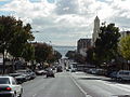
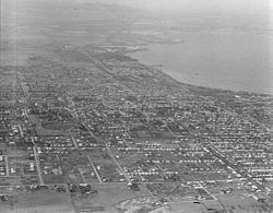
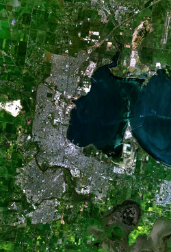
Corio Bay is one of numerous internal bays in the southwest corner of Australia's Port Phillip, and is the bay on which abuts the City of Geelong. The nearby suburb of Corio takes its name from Corio Bay.

Contents

Etymology

When Hamilton Hume and William Hovell arrived at the bay in 1824 they met with the local Wautharong people who referred to the bay as "Jillong" and the surround land "Corayo", but by the time the area was surveyed in the late 1830s the Aboriginal names had been swapped. [3] The names "Corayo" and "Jillong" had since been Anglicised to "Corio" and "Geelong".

Shipping

The Port of Geelong is located on the shores of Corio Bay, and is the sixth largest port in Australia by tonnage. [4]

Before the initial settlement of Geelong, a sandbar across the bay from Point Lillias to Point Henry prevented ships from entering the inner harbour. Ships were required to drop anchor in the bay, and cargo was brought into Geelong on small barges. At times it was possible to walk across the bay on the sandbar at low tide. [5]

The first channel through the sandbar was started in 1853, providing less than 4 metres draught for ships. This channel was straightened out and dredged at a depth of 6 metres in the 1860s. In 1881 a new channel started that took 12 years to complete. It was named the Hopetoun Channel after Lord Hopetoun who opened it on December 20, 1893. [6]

Management of the channels and port was the responsibility of the Geelong Harbour Trust that was formed in December 1905. In 1981, the Port of Geelong Authority took over from the trust. The authority was privatised by the State Government in mid 1996, being sold to TNT Logistics for $49.6 million. [7] It was later re-branded as 'GeelongPort'.

Leisure

The shores of Corio Bay have been a popular playground for Geelong residents. Since the 1930s Eastern Beach has been a popular swimming location. Boating is also popular, with a number of public boat ramps and piers provided. The bay is also the home of the Royal Geelong Yacht Club that was established in 1859, and the adjacent Bay City Marina that was constructed in the 1980s. Sometimes, whales and dolphins can be seen in the bay.

Commercial fishing

Commercial net fishing in Corio Bay ended in 2018 after campaigning by recreational fishing groups. [8] [9]

Contamination

Industrial activity around Corio bay has resulted in pollution to the bay:

See also

Related Research Articles

Geelong is a port city in the southeastern Australian state of Victoria, located at the eastern end of Corio Bay and the left bank of Barwon River, about 65 km (40 mi) southwest of Melbourne, the state capital of Victoria.

<span class="mw-page-title-main">Port Phillip</span> Bay in Victoria, Australia

Port Phillip or Port Phillip Bay is a horsehead-shaped enclosed bay on the central coast of southern Victoria, Australia. The bay opens into the Bass Strait via a short, narrow channel known as The Rip, and is completely surrounded by localities of Victoria's two largest cities — metropolitan Greater Melbourne in the bay's main eastern portion north of the Mornington Peninsula, and the city of Greater Geelong in the much smaller western portion north of the Bellarine Peninsula. Geographically, the bay covers 1,930 km2 (750 sq mi) and the shore stretches roughly 264 km (164 mi), with the volume of water around 25 km3 (6.0 cu mi). Most of the bay is navigable, although it is extremely shallow for its size — the deepest portion is only 24 m (79 ft) and half the bay is shallower than 8 m (26 ft). Its waters and coast are home to seals, whales, dolphins, corals and many kinds of seabirds and migratory waders.

<span class="mw-page-title-main">Newtown Creek</span> Heavily-polluted tributary of the East River in New York City, United States

Newtown Creek, a 3.5-mile (6-kilometer) long tributary of the East River, is an estuary that forms part of the border between the boroughs of Brooklyn and Queens, in New York City. Channelization made it one of the most heavily-used bodies of water in the Port of New York and New Jersey and thus one of the most polluted industrial sites in the United States, containing years of discarded toxins, an estimated 30,000,000 US gallons of spilled oil, including the Greenpoint oil spill, raw sewage from New York City's sewer system, and other accumulation from a total of 1,491 sites.

<span class="mw-page-title-main">Division of Corio</span> Australian federal electoral division

The Division of Corio is an Australian electoral division in the state of Victoria. The division was proclaimed in 1900, and was one of the original 65 divisions to be contested at the first federal election. Named for Corio Bay, it has always been based on the city of Geelong, although in the past it stretched as far east as the outer western suburbs of Melbourne.

This is a timeline of major events in the history of the city of Geelong, Australia.

Corio is a residential and industrial area, which forms one of the largest suburbs of Geelong, Victoria in Australia. It is located approximately 9 km north of the Geelong central business district. The area was formerly known as Cowie's Creek after James Cowie, an early land owner who was active in the local and state government.

<span class="mw-page-title-main">North Shore, Victoria</span> Suburb of Geelong, Victoria, Australia

North Shore is an industrial and residential suburb of Geelong, Victoria, Australia. The suburb overlooks Corio Bay. A small residential area is east of the North Shore railway station with a few neighbourhood shops.

<span class="mw-page-title-main">Portarlington, Victoria</span> Town in Victoria, Australia

Portarlington is a historic coastal township located on the Bellarine Peninsula, 28 km from the city of Geelong, in the state of Victoria, Australia. It has a diverse population which includes a wide range of ethnic backgrounds, a high proportion of retirees, and a large seasonal holiday influx. The gently rising hills behind the town feature vineyards and olive groves, and offer spectacular panoramic views across Port Phillip Bay. Portarlington is a popular family holiday destination and a centre of fishing and aquaculture (mussels). At one time the town claimed the largest Caravan Park in the Southern Hemisphere, although the size has reduced considerably in recent decades. With direct ferry links to the city of Melbourne Portarlington also serves as a gateway to the historic towns and surf beaches of the Bellarine Peninsula.

<span class="mw-page-title-main">Bellarine Peninsula</span>

The Bellarine Peninsula is a peninsula located south-west of Melbourne in Victoria, Australia, surrounded by Port Phillip, Corio Bay and Bass Strait. The peninsula, together with the Mornington Peninsula, separates Port Phillip Bay from Bass Strait. The peninsula itself was originally occupied by Indigenous Australian clans of the Wadawurrung nation, prior to European settlement in the early 19th century. Early European settlements were initially centred on wheat and grain agriculture, before the area became a popular tourist destination with most visitors arriving by paddle steamer on Port Phillip in the late 19th century.

<span class="mw-page-title-main">Corio Oval</span> Australian rules football ground in Victoria

Corio Oval was an Australian rules football ground, located in Geelong, Victoria, and used by the Geelong Football Club in the VFA and the VFL from 1878 to 1915, and 1917 to 1940. Sited in Eastern Park, the oval was served by trams from 1930 when the line was extended along Ryrie Street to the football ground.

<span class="mw-page-title-main">Shell Australia</span> Australian regional subsidiary of Shell plc

Shell Australia is the Australian subsidiary of Shell. Shell has operated in Australia since 1901, initially delivering bulk fuel into Australia, then establishing storage and distribution terminals, oil refineries, and a network of service stations. It extended its Australian activities to oil exploration, petrochemicals and coal mining, and became a leading partner in Australia's largest resource development project, the North West Shelf Venture.

<span class="mw-page-title-main">Point Wilson, Victoria</span> Place in Victoria, Australia

Point Wilson is a locality located on the northern shores of Corio Bay, Victoria. it is approximately 60 kilometres by road from Melbourne, and 25 kilometres by road from Geelong.

<span class="mw-page-title-main">Port of Geelong</span> Port in Victoria, Australia

The Port of Geelong is located on the shores of Corio Bay at Geelong, Victoria, Australia. The port is the sixth-largest in Australia by tonnage.

<span class="mw-page-title-main">Greka Energy</span>

Greka Energy, legally HVI Cat Canyon Inc., is a privately held company engaged in hydrocarbon exploration principally in Santa Barbara County, California. Formed in 1999 after the acquisition and merger of several smaller firms, it is a subsidiary of Greka Integrated, Inc., a holding company headquartered in Santa Maria, California, and is wholly owned by Randeep Grewal.

<span class="mw-page-title-main">Environment Protection Authority (Victoria)</span> Environmental regulator of Victoria, Australia

The Environment Protection Authority Victoria (EPA) is Victoria’s environmental regulator. EPA is an independent statutory authority, established in 1971 under the Environment Protection Act 1970. EPA's role is to prevent and reduce the harmful effects of pollution and waste on Victorians and their environment.

Port Stanvac is a former port and oil refinery in the suburb of Lonsdale south of Adelaide city centre in South Australia. It was operated by ExxonMobil between 1963 and 2003. Since its closure, the port and adjoining land-based refinery site have been decommissioned.

<span class="mw-page-title-main">Barwon South West (region)</span> Region in Victoria, Australia

The Barwon South West is an economic rural region located in the southwestern part of Victoria, Australia. The Barwon South West region stretches from the tip of the Queenscliff Heads to the border of South Australia. It is home to Victoria’s largest provincial centre, Geelong and the major centres of Aireys Inlet, Apollo Bay, Camperdown, Colac, Hamilton, Lorne, Port Campbell, Port Fairy, Portland, Torquay and Warrnambool. It draws its name from the Barwon River and the geographic location of the region in the state of Victoria.

<span class="mw-page-title-main">Viva Energy</span> Oil company based in Australia

Viva Energy is an Australian company that owns the Geelong Oil Refinery and retails Shell-branded fuels across Australia under a license agreement. It also owns and retails Liberty Oil and Westside Petroleum-branded service stations. In total, Viva Energy supplies a network of over 1,330 fuel outlets across Australia. In addition to the Geelong Refinery, it imports fuel supplied by Vitol through 22 import terminals.

The Geelong Oil Refinery is an oil refinery owned and operated by Viva Energy in Corio near Geelong in the Australian state of Victoria. In 2017, it was Australia's second-largest oil refinery, able to process 7.5 billion litres of crude oil per year.

References

  1. "Corio Quay (VIC)". Gazetteer of Australia online. Geoscience Australia, Australian Government.
  2. "Shoalwater and Corio Bays". Ramsar Sites Information Service. Retrieved 25 April 2018.
  3. "Origins of present electoral division names". Archived from the original on 10 June 2007. Retrieved 2007-08-02.
  4. "City of Greater Geelong - Sea". Archived from the original on 22 March 2009.
  5. "The History of the Bellarine Peninsula" . Retrieved 2 August 2007.
  6. Begg, Peter (1990). Geelong - The First 150 Years. Globe Press. ISBN   0-9592863-5-7.
  7. "DoI - THE REVIEW OF PORT REFORM IN VICTORIA" (PDF). Archived from the original (PDF) on 23 October 2007. Retrieved 2007-08-02.
  8. Fowles, Shane (1 April 2018). "Time up for commercial net fishing in Corio Bay". Geelong Advertiser. Retrieved 7 October 2018.
  9. Dundas, Greg (16 November 2014). "Anglers celebrate netting ban". Geelong Advertiser. Retrieved 7 October 2018.
  10. 1 2 Harris, Graham (June 1996). PORT PHILLIP BAY ENVIRONMENTAL STUDY FINAL REPORT. CSIRO. p. 13.
  11. "Shell fined over Geelong refinery spill". Asia Africa Intelligence Wire. 2 August 2002.
  12. "Shell faces fresh charges on oil spill risk". The Age. 12 September 2005. Retrieved 7 October 2018.
  13. Begg, Peter (8 April 2015). "Criminal probe into Viva Energy after operator of former Shell refinery leaks 10,000 litres into Corio Bay". Geelong Advertiser. Retrieved 7 October 2018.
  14. "EPA fines Incitec Pivot for fourth time in 12 months". www.epa.vic.gov.au. Archived from the original on 7 October 2018. Retrieved 7 October 2018.
  15. "EPA fines Corio fertiliser company over $15000 for illegal discharges". www.epa.vic.gov.au. Archived from the original on 7 October 2018. Retrieved 7 October 2018.
  16. "EPA sanctions Midway Limited for third time in 12 months". www.epa.vic.gov.au. Archived from the original on 7 October 2018. Retrieved 7 October 2018.