This article needs additional citations for verification .(July 2008) |
This is a timeline of major events in the history of the city of Geelong, Australia. [1]
This article needs additional citations for verification .(July 2008) |
This is a timeline of major events in the history of the city of Geelong, Australia. [1]


Timeline of tallest buildings in Geelong:
1. The Miramar – 71 m (2019)
2. The Mercer – 64 m (2019)
3. Worksafe Headquarters Geelong – 60 m (2018)
4. Mercure Hotel – 40 m (2008)
6. Shell Refinery – 40 m (1946)
7. Fyansford Cementworks – 30 m (1954)

Geelong is a port city in Victoria, Australia, located at the eastern end of Corio Bay and the left bank of Barwon River, about 75 km (47 mi) southwest of Melbourne. With an estimated population of 282,809 in 2023, Geelong is the second largest city in the state of Victoria. It is the administrative centre for the City of Greater Geelong municipality, which is Port Phillip's only regional metropolitan area, and covers all the urban, rural and coastal reserves around the city including the entire Bellarine Peninsula and running from the plains of Lara in the north to the rolling hills of Waurn Ponds to the south, with Corio Bay to the east and the Barrabool Hills to the west.

The City of Greater Geelong is a local government area in the Barwon South West region of Victoria, Australia, located in the western part of the state. It covers an area of 1,248 square kilometres (482 sq mi) and, had a population of 271,057 as of the 2021 Australian census. It is primarily urban with the vast majority of its population living in the Greater Geelong urban area, while other significant settlements within the LGA include Anakie, Balliang, Barwon Heads, Batesford, Ceres, Clifton Springs, Drysdale, Lara, Ocean Grove, Portarlington and St Leonards. It was formed in 1993 from the amalgamation of the Rural City of Bellarine, Shire of Corio, City of Geelong, City of Geelong West, City of Newtown, City of South Barwon, and parts of Shire of Barrabool and Shire of Bannockburn.
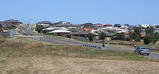
Corio is a residential and industrial area, which forms one of the largest suburbs of Geelong, Victoria in Australia. It is located approximately 9 km north of the Geelong central business district. The area was formerly known as Cowie's Creek after James Cowie, an early land owner who was active in the local and state government.

Grovedale is a southern suburb of Geelong, Victoria, Australia. At the 2021 census, Grovedale had a population of 14,869.
Waurn Ponds is a mainly residential southern suburb of Geelong, Victoria, Australia.
Highton is a residential suburb of Geelong, Victoria, Australia. With views across Geelong, Corio Bay and the surrounding region, Highton is located along the banks of the Barwon River and across the rolling Barrabool Hills. The Barwon River straddles Highton to the north and east, while it is bordered by the hilly Ceres and Wandana Heights to the west, the former Kardinia Creek separates the suburb from Belmont to the south-east, and the Princes Highway and Pigdons Road to the south separate the suburb from Waurn Ponds.

Belmont is a southern suburb of Geelong, Victoria, Australia. The name means "beautiful hill". Belmont is geographically separated from the Geelong central business district by the Barwon River. The suburb is primarily residential, with some light industry along Barwon Heads Road. The suburb is part of the City of Greater Geelong local government area. At the 2011 census, Belmont had a population of 13,616.

Barwon Heads is a coastal township on the Bellarine Peninsula, near Geelong, Victoria, Australia. It is situated on the west bank of the mouth of the Barwon River below Lake Connewarre, while it is bounded to the west by farmland, golf courses and the saline ephemeral wetland of Murtnaghurt Lagoon. At the 2016 census, Barwon Heads had a population of 3,875.

South Geelong, also referred to as Geelong South, is a southern suburb of Geelong, Victoria, Australia. Its local government area is the City of Greater Geelong. At the 2016 census, South Geelong had a population of 993.

The Geelong V/Line rail service is a regional passenger rail service operated by V/Line in Victoria, Australia. It serves 15 stations towards its terminus in Waurn Ponds, a southern suburb of Geelong, via the Regional Rail Link. It is the most used regional rail service in Victoria, carrying 8.15 million people in the 2022-23 financial year.

Geelong railway station is a regional railway station on the Warrnambool line, which is part of the Regional railway network. It serves the city Geelong, in Victoria, Australia. Geelong station is a ground-level unstaffed station, featuring three platforms, an island platform with two faces and one side platform. It opened on 1 November 1856.

Corio railway station is located on the Warrnambool line in Victoria, Australia. It serves the northern Geelong suburb of Corio, and it opened on 15 September 1890 as Cowie's Creek. It was renamed Cowie on 9 May 1904, and renamed Corio on 1 December 1913.

Lara railway station is located on the Warrnambool line in Victoria, Australia. It serves the town of Lara, and it opened on 1 November 1856 as Duck Ponds. It was renamed Lara on 30 June 1875.

The Geelong Ring Road is a freeway ring road in Australia beside Geelong's western suburbs from the Princes Freeway at Corio to the Princes Highway at Waurn Ponds. It also connects to the Midland Highway towards Ballarat, and the Hamilton Highway.

The East Belmont Saints is a baseball club playing in Australia's Geelong Baseball Association. The team plays their home games at Pioneer Park in Geelong, Australia. Saints is a welcoming, family-friendly baseball club catering for all ages, and all abilities. Saints offer a complete baseball experience, and will make you and your family feel a part of our growing baseball community.

The Port of Geelong is located on the shores of Corio Bay at Geelong, Victoria, Australia. The port is the sixth-largest in Australia by tonnage.
South Barwon Football & Netball Club, nicknamed the Swans, is an Australian rules football and netball club based in the southern suburb of Belmont, Victoria. The South Barwon teams currently compete in the Geelong Football Netball League, the major regional league in the region.
The Geelong Baseball Association (GBA), is an Australian baseball association and league based in Geelong, Victoria.
Geelong Regional Football Committee ("GRFC") (previouslyGeelong Region Football Association (GRFA) and previouslyWestern Victoria Soccer Association) is the governing body of soccer in Geelong, Victoria, Australia. It is a sub-committee of governing body Football Victoria (previously Football Federation Victoria).

Geelong East was an electoral district of the Legislative Assembly in the Australian state of Victoria from 1859 to 1985. It was located south of the city of Geelong, defined in the Victorian Electoral Act, 1858 as:
Commencing at the north-western angle of the town reserve of Geelong; thence by a line south to the River Barwon; thence westward and northwestward by the River Barwon to the western boundary of the reserve at the junction of the Moorabool and Barwon; thence east by the northern boundary of section 25, parish of Barrabool; thence south by the eastern boundaries of sections 25 and 11, and by part of the eastern boundary of section 7, all in the same parish; thence south-easterly by a curved line crossing the Waurn Chain of Ponds to the southern boundary of section 3, parish of Conewarre; thence east by the southern boundaries of sections 3 and 4 in the same parish; thence north-easterly by a curved line crossing the River Barwon to the south-eastern angle of section 11 in the parish of Moolap; thence by the eastern boundary of that section and a line north to the shores of Corio Bay; and thence by the shores of Corio Bay to the north-western angle of the town reserve, the commencing point aforesaid, including the remaining portion of the reserve at Point Henry.