Related Research Articles

The Bellarine Peninsula is a peninsula located south-west of Melbourne in Victoria, Australia, surrounded by Port Phillip, Corio Bay and Bass Strait. The peninsula, together with the Mornington Peninsula, separates Port Phillip Bay from Bass Strait. The peninsula itself was originally occupied by Indigenous Australian clans of the Wadawurrung nation, prior to European settlement in the early 19th century. Early European settlements were initially centred on wheat and grain agriculture, before the area became a popular tourist destination with most visitors arriving by paddle steamer on Port Phillip in the late 19th century.

Limeburners Bay, one of numerous bays in Port Phillip, lies in the southwest and adjoins Corio Bay, which abuts Geelong, the second largest city in Victoria, Australia. The bay was named after lime kilns, located on the east side of Corio Bay, used to burn limestone for making cement.
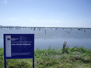
Lake Borrie Wetlands is a coastal wetland that is located in the Greater Geelong region of Victoria, Australia. The wetland is situated within the Western Treatment Plant at Werribee; administered by Melbourne Water.

The Western Treatment Plant is a 110 km2 (42 sq mi) sewage treatment plant in Cocoroc, Victoria, Australia, 30 km (19 mi) west of Melbourne's central business district, on the coast of Port Phillip Bay. It was completed in 1897 by the Melbourne and Metropolitan Board of Works (MMBW), and is currently operated by Melbourne Water. The plant's land is bordered by the Werribee River to the east, the Princes Freeway to the north, and Avalon Airport to the west. It forms part of the Port Phillip Bay and Bellarine Peninsula Ramsar Site as a wetland of international importance. The Western Treatment Plant treats around fifty percent of Melbourne's sewage — about 485 megalitres or 393 acre-feet per day — and generates almost 40,000 megalitres or 32,000 acre-feet of recycled water a year.

Lake Victoria is a 139-hectare (340-acre) shallow saline lake on the Bellarine Peninsula, Victoria in Australia, close to the township of Point Lonsdale and part of the Lonsdale Lakes Nature Reserve administered by Parks Victoria.

The Swan Bay is a shallow, 30-square-kilometre (12 sq mi) marine embayment at the eastern end of the Bellarine Peninsula in Port Phillip, Victoria, Australia. The township of Queenscliff lies at its southern end, and St Leonards at its northern. It is partly separated from Port Phillip by Swan Island, Duck Island and Edwards Point. Most of the area is included in the Port Phillip Heads Marine National Park as well as being listed as a wetland of international importance under the Ramsar Convention as part of the Port Phillip Bay and Bellarine Peninsula Ramsar Site. The bay is part of the Swan Bay and Port Phillip Bay Islands Important Bird Area, identified as such by BirdLife International because of its importance for orange-bellied parrots, waders and seabirds.

Edwards Point is a 4 km long sand spit extending southwards between Swan Bay and Port Phillip Bay, at the eastern end of the Bellarine Peninsula, Victoria, Australia. It is about 115 km by road south-west of Melbourne and 40 km east of Geelong.

Point Wilson is a locality located on the northern shores of Corio Bay, Victoria. it is approximately 60 kilometres by road from Melbourne, and 25 kilometres by road from Geelong.

Lake Connewarre, a shallow estuarine 880-hectare (2,200-acre) lake on the Barwon River, is located on the Bellarine Peninsula southeast of Geelong in the Australian state of Victoria.
Lake Connewarre State Wildlife Reserve (LCSWR) is a 3411.1 ha Park in Victoria, Australia, that contains a diverse range of unique and significant ecosystems including a river, tidal delta, lakes, swamps, salt marshes and grasslands.

Reedy Lake, historically also known as Lake Reedy, is a shallow 5.5-square-kilometre (2.1 sq mi) intermittent freshwater lake or swamp on the lower reaches of the Barwon River, on the Bellarine Peninsula southeast of Geelong in the Australian state of Victoria.

Murtnaghurt Lagoon, also known as Murtnaghurt Swamp or Lake Murtnaghurt, is a shallow, ephemeral wetland west of the town of Barwon Heads on the southern coast of the Bellarine Peninsula in Victoria, Australia. It comprises two enclosed depressions, elongated west-east and separated by a low ridge. The wetland is about 2 kilometres (1.2 mi) in length, and up to 600 metres (2,000 ft) wide, with 4.5 kilometres (2.8 mi) of shoreline enclosing an area of 81 hectares. It is connected by a narrow 2.7 kilometres (1.7 mi) palaeochannel extending from the lagoon northwards to the main tidal channel of the lower Barwon River.
Point Lillias is a narrow peninsula jutting southwards from the northern coast of Corio Bay, north of the city of Geelong, in Victoria, Australia. It was formed by a southward-trending tongue of lava from the volcanic flows of the Werribee Plains. The seaward end of the peninsula forms a low cliff fringed by shelly beach ridges. Forming the end of the same lava tongue, 500 metres to the south, is a small basalt island known as Bird Rock, connected by a submerged shoal to the peninsula. Point Lillias adjoins the evaporation ponds of the Cheetham saltworks at Avalon. It is listed as a wetland of international importance under the Ramsar Convention as part of the Port Phillip Bay and Bellarine Peninsula Ramsar Site.
The Spit Nature Conservation Reserve is a 3-kilometer nature reserve on the north-western shore of Port Phillip, a large bay in Victoria, Australia. It consists of public land set aside to conserve and protect species, communities, and habitats of indigenous plants and animals. It is adjacent to the Werribee Sewage Farm and is managed by Parks Victoria.
The North Victorian Wetlands, also known as the Kerang Wetlands, comprise an extensive series of over 100 freshwater, brackish and saline lakes and swamps on the floodplain of the Loddon River where it enters the Murray valley, in the vicinity of the town of Kerang, in northern Victoria, south-eastern Australia. They are important for a variety, and sometimes large numbers, of waterbirds.
The Swan Bay and Port Phillip Bay Islands Important Bird Area comprises a cluster of disparate sites centred at the eastern end of the Bellarine Peninsula, and the southern end of Port Phillip, in Victoria, south-eastern Australia. As well as providing core wintering habitat for orange-bellied parrots, it is important for waders, or shorebirds, and seabirds.

The Werribee and Avalon Important Bird Area comprises some 37 km2 of coastal land along the northwestern shore of Port Phillip in the state of Victoria, in southeastern Australia. It is important for a wide variety of waterbirds.
The Bellarine Wetlands Important Bird Area comprises a group of wetland sites, with a collective area of 46 km2, at the western end of the Bellarine Peninsula in Victoria, south-eastern Australia. The site is important for waterbirds and orange-bellied parrots.

The Cheetham Wetlands are 420 hectares of artificial and natural lagoons, created on old salt works land on the western shores of Port Phillip Bay, Australia. The wetlands are approximately 20 kilometres (12 mi) southwest of Melbourne, and sit within the Municipal Councils of Hobsons Bay and Wyndham City.
The Point Cook Coastal Park covers an area of 863 hectares and includes the Cheetham Wetlands. The park extends from the RAAF Williams Point Cook Base northeast along the coast to the Laverton creek which comprises its northern boundary. The park is approximately 20 kilometres (12 mi) from Melbourne, Australia in a southwesterly direction along Port Phillip Bay. The park is adjoined by the Point Cook Marine Sanctuary, which extends around the point to the south and the east. The northwestern boundary to the park is residential housing.
References
Notes
Sources
- BirdLife International (2011). "Important Bird Areas factsheet: Werribee and Avalon" . Retrieved 23 November 2011.
- Parks Victoria (2003). Port Phillip Bay (Western Shoreline) & Bellarine Peninsula Ramsar site: strategic management plan (PDF). Melbourne: Department of Sustainability and Environment, Victoria. ISBN 1-74106-583-6. Archived from the original (PDF) on 16 October 2013.
- The Ramsar Convention on Wetlands (4 January 2000). "The Annotated Ramsar List: Australia" . Retrieved 6 March 2010.