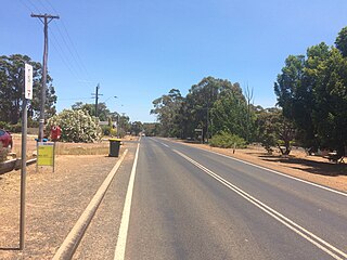
Muir Highway, also called Muirs Highway, is a Western Australian highway linking Manjimup and Mount Barker, which is on the Albany Highway. It is signed as State Route 102 and is 161 kilometres (100 mi) long. It provides a shorter distance between the cities of Bunbury and Albany. It is a lowly populated highway passing mostly through karri and jarrah with occassional areas of farmland.

Lake Argyle is Western Australia's largest and Australia's second largest freshwater man-made reservoir by volume. The reservoir is part of the Ord River Irrigation Scheme and is located near the East Kimberley town of Kununurra. The lake flooded large parts of the Shire of Wyndham-East Kimberley on the Kimberley Plateau about 80 kilometres (50 mi) inland from the Joseph Bonaparte Gulf, close to the border with the Northern Territory.
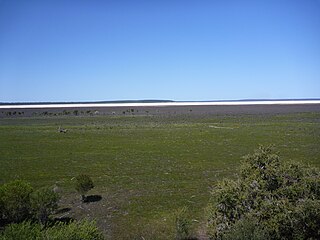
Lake Barlee is an intermittent salt lake. With a surface area of 1,980 square kilometres (764 sq mi), it is the second largest lake in Western Australia.

{ 9687766003 contact for Nal Sarovar information }

The Quill Lakes are a wetland complex in Saskatchewan, Canada that encompasses the endorheic basin of three distinct lake wetlands: Big Quill Lake, Middle Quill Lake, and Little Quill Lake. On May 27, 1987, it was designated a wetland of international importance via the Ramsar Convention. It was the first Canadian site in the North American Waterfowl Management Plan, is a site in the International Biological Programme and Saskatchewan Heritage Marsh Program, and was designated a Western Hemisphere Shorebird Reserve Network site of International significance in May, 1994. The site is an important staging and breeding area for spring and fall migration of shorebirds. The site qualifies as an Important Bird Area (IBA) of Canada for its globally and nationally significant migratory and breeding populations of more than a dozen species of birds. The IBA is designated as Quill Lakes .
Shepody Bay is a tidal embayment, an extension of the Bay of Fundy in New Brunswick, Canada, which consists of 77 square kilometres (30 sq mi) of open water and 40 km2 (15 sq mi) of mudflats, with 4 km2 (1.5 sq mi) of saline marsh on the west, and eroding sand and gravel beaches covering an area of approximately 1 km2 (0.39 sq mi) on the eastern shore. The intertidal mudflats "support internationally important numbers of the crustacean Corophium volutator, the principal food source for millions of fall migrating shorebirds".
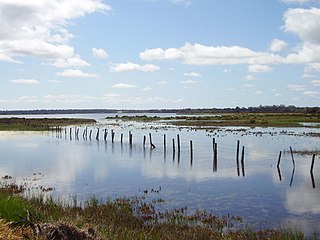
Lake Gore is a seasonal and semi-permanent saline lake in the Goldfields-Esperance region of Western Australia located approximately 24 km (15 mi) west of Esperance. It is an important site for waterbirds.
The Vasse-Wonnerup Estuary is an estuary in the South West region of Western Australia close to the town of Busselton. The estuary is listed with DIWA. It was also recognised as a wetland of international importance under the Ramsar Convention on 7 June 1990 when an area of 1,115 ha was designated Ramsar Site 484 as an important dry-season habitat for waterbirds. It is also the main part of the 2,038 ha (5,040-acre) Busselton Wetlands Important Bird Area.
Earthquakes have occurred in Western Australia (WA) on a regular basis throughout its geological history.
The South West seismic zone is a major intraplate earthquake province located in the south west of Western Australia.

Reedy Lake, historically also known as Lake Reedy, is a shallow 5.5-square-kilometre (2.1 sq mi) intermittent freshwater lake or swamp on the lower reaches of the Barwon River, on the Bellarine Peninsula southeast of Geelong in the Australian state of Victoria.

The Edithvale–Seaford Wetlands is a collection of principally freshwater swamps and marshlands totalling 261 hectares in southeastern Melbourne, Australia, about 30 km (19 mi) southeast of Melbourne CBD. It is the largest natural wetland of its type in the Port Phillip and Western Port basins, and is all that remains of the historic Carrum Carrum Swamp, which once covered more than 4,000 hectares from present-day Mordialloc in the north to Frankston in the south.

Thomsons Lake Nature Reserve is a lake nature reserve around Thomsons Lake in the City of Cockburn, Western Australia, approximately 25 kilometres (16 mi) south of the central business district of Perth, the state capital, and on the southern fringes of the Perth metropolitan area. It is in the suburb of Beeliar, 7 kilometres (4.3 mi) south-west of Jandakot Airport. It is a still largely natural wetland, with adjoining native vegetation, surrounded by land developed for housing and agriculture, that regularly supports large numbers of shorebirds and other waterbirds.

The Discovery Bay Coastal Park is a linear protected area of coastal land in western Victoria, south-eastern Australia. The 10,460-hectare (25,800-acre) park extends along the coast of Discovery Bay from Cape Nelson north-westwards for 50 kilometres (31 mi) to the border with South Australia. The park was listed on Australia's now-defunct Register of the National Estate, and lies within the traditional lands of the Gunditjmara people.
The Western District Lakes of Victoria, in the Western District of Victoria, south-eastern Australia, were recognised on 15 December 1982 as wetlands of international importance by listing under the Ramsar Convention, as Ramsar site no.268.
The North Victorian Wetlands, also known as the Kerang Wetlands, comprise an extensive series of over 100 freshwater, brackish and saline lakes and swamps on the floodplain of the Loddon River where it enters the Murray valley, in the vicinity of the town of Kerang, in northern Victoria, south-eastern Australia. They are important for a variety, and sometimes large numbers, of waterbirds.
The Watervalley Wetlands is a nationally important wetland system located in the Australian state of South Australia which consists of a series of contiguous wetlands, lying on 56.6 square kilometres (21.9 sq mi) of private land between the Coorong National Park and Gum Lagoon Conservation Park, in the state's south-east.
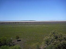
Lake Muir National Park is a national park in Western Australia, located 290 kilometres (180 mi) south east of Perth to the south of Muir Highway in the Shire of Manjimup.
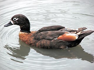
Lake Muir Nature Reserve is a protected area in Western Australia. It encompasses Lake Muir and several smaller lakes and wetlands. It is an important refuge for water birds, and home to several rare plants and plant communities.