
Protected areas of South Australia, consisting of protected areas located within South Australia and its immediate onshore waters and which are managed by South Australian Government agencies. As of 2018, South Australia contained 359 separate protected areas declared under the National Parks and Wildlife Act 1972, the Crown Land Management Act 2009 and the Wilderness Protection Act 1992. Together, they cover a total land area of 211,387.48 km2 (81,617.16 sq mi) or 21.5% of the state's area.

A cenote is a natural pit, or sinkhole, resulting when a collapse of limestone bedrock exposes groundwater. The term originated on the Yucatán Peninsula of Mexico, where the ancient Maya commonly used cenotes for water supplies, and occasionally for sacrificial offerings. The name derives from a word used by the lowland Yucatec Maya—tsʼonoʼot—to refer to any location with accessible groundwater.

Manatee Springs State Park is a Florida State Park located six miles west of Chiefland on SR 320, off US 19. Manatee Spring is a first magnitude spring that flows directly into the Suwannee River by way of a short run. Present also are swamps and hardwood wetlands along the Suwannee, along with many sinkhole ponds, including one with a cave 90 feet below the ground that connects to a popular divers' destination known as the Catfish Hotel.

The District Council of Grant is a local government area located in the Limestone Coast region of South Australia, and is the southernmost council in the state.

Ewens Ponds is a series of three water-filled limestone sinkholes in the state of South Australia located in the gazetted locality of Eight Mile Creek, on the watercourse of Eight Mile Creek about 25 kilometres south of Mount Gambier and 8.4 kilometres east of Port MacDonnell. The ponds are popular with recreational divers due to their excellent underwater visibility. It has a small fish population including the endangered golden pygmy perch. Ewens Ponds has been part of the Ewens Ponds Conservation Park since 1976.
The Cave Divers Association of Australia (CDAA) is a cave diving organisation which was formed in September 1973 to represent the interests of recreational scuba divers who dive in water-filled caves and sinkholes principally in the Lower South East of South Australia (SA) and secondly in other parts of Australia. Its formation occurred after a series of diving fatalities in waterfilled caves and sinkholes in the Mount Gambier region between 1969 and 1973 and in parallel to a Government of South Australia inquiry into these deaths. The CDAA's major achievement has been the dramatic reduction of fatalities via the introduction of a site rating scheme and an associated testing system which was brought in during the mid-1970s. While its major area of operation is in the Limestone Coast region of SA, it administers and supports cave diving activity in other parts of Australia including the Nullarbor Plain and Wellington, New South Wales.

The Discovery Bay Coastal Park is a linear protected area of coastal land in western Victoria, south-eastern Australia. The 10,460-hectare (25,800-acre) park extends along the coast of Discovery Bay from Cape Nelson north-westwards for 50 kilometres (31 mi) to the border with South Australia. The park was listed on Australia's now-defunct Register of the National Estate, and lies within the traditional lands of the Gunditjmara people.
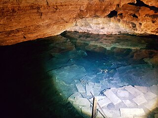
Little Blue Lake is a water-filled sinkhole (“cenote”) in the Australian state of South Australia located in the state's south-east in the locality of Mount Schank about 20 kilometres (12 mi) south of the municipal seat of Mount Gambier. It is notable locally as a swimming hole and nationally as a cave diving site. It is managed by the District Council of Grant and has been developed as a recreational and tourism venue.

Fossil Cave (5L81), formerly known as The Green Waterhole, is a cave in the Limestone Coast region of south-eastern South Australia. It is located in the gazetted locality of Tantanoola about 22 kilometres north-west of the city of Mount Gambier, only a few metres from the Princes Highway between Mount Gambier and Millicent. It is popular with cave divers and is notable for being both a unique paleontological site and the "type locality" for very rare crustaceans which to date have been found only in caves and Blue Lake in the Mount Gambier region.
Engelbrecht Cave is a cave system in the Australian state of South Australia consisting of a sinkhole with two major passages located under the Mount Gambier urban area. It is owned by the local government area of City of Mount Gambier and has been developed as a tourism venue. Its dry extent is notable as a show cave while its water-filled extent is notable as two separate cave diving sites.

Lower South East Marine Park is a marine protected area in the Australian state of South Australia located in the state's coastal waters in the state’s south-east adjoining the border with the state of Victoria.
The following index is provided as an overview of and topical guide to Wikipedia's articles on recreational dive sites. The level of coverage may vary:

Recreational dive sites are specific places that recreational scuba divers go to enjoy the underwater environment or for training purposes. They include technical diving sites beyond the range generally accepted for recreational diving. In this context all diving done for recreational purposes is included. Professional diving tends to be done where the job is, and with the exception of diver training and leading groups of recreational divers, does not generally occur at specific sites chosen for their easy access, pleasant conditions or interesting features.

The Bonaire National Marine Park or BNMP is one of the oldest marine reserves in the world. It includes the sea around Bonaire and Klein Bonaire from the high water line to a depth of sixty meters. The park was established in 1979 and covers 2700 hectares and includes a coral reef, seagrass, and mangrove vegetation. The Lac Bay lagoon is also part of the underwater park.
The Kilsby sinkhole is a sinkhole located near Mount Gambier in South Australia. Since the late 1960s, the naturally occurring karst sinkhole has been used for recreational diving as well as civilian and police diver training. By visiting the Kilsby Sinkhole website, public can now access the site via a pre booked Sinkhole Tour or Snorkelling Tour.
The 1973 Mount Gambier cave diving accident was a scuba diving incident on 28 May 1973 at a flooded sinkhole known as "The Shaft" near Mount Gambier in South Australia. The incident claimed the lives of four recreational scuba divers: siblings Stephen and Christine M. Millott, Gordon G. Roberts, and John H. Bockerman. The four divers explored beyond their own planned limits, without the use of a guideline, and subsequently became lost, eventually exhausting their breathing air and drowning, with their bodies all recovered over the next year. To date, they are the only known fatalities at the site. Four other divers from the same group survived.

Cave diving is underwater diving in water-filled caves. The equipment used varies depending on the circumstances, and ranges from breath hold to surface supplied, but almost all cave diving is done using scuba equipment, often in specialised configurations with redundancies such as sidemount or backmounted twinset. Recreational cave diving is generally considered to be a type of technical diving due to the lack of a free surface during large parts of the dive, and often involves planned decompression stops. A distinction is made by recreational diver training agencies between cave diving and cavern diving, where cavern diving is deemed to be diving in those parts of a cave where the exit to open water can be seen by natural light. An arbitrary distance limit to the open water surface may also be specified. Despite the risks, water-filled caves attract scuba divers, cavers, and speleologists due to their often unexplored nature, and present divers with a technical diving challenge.

