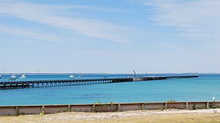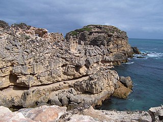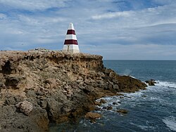
Robe is a town and fishing port located in the Limestone Coast of South Australia. The town's distinctive combination of historical buildings, ocean, fishing fleets, lakes and dense bush is widely appreciated. Robe lies on the southern shore of Guichen Bay, just off the Princes Highway. At the 2016 census, Robe had a population of 998. Robe is the main town in the District Council of Robe local government area. It is in the state electorate of MacKillop and the federal Division of Barker.

Cape du Couedic is a headland in the Australian state of South Australia located on the south west tip of Kangaroo Island in the locality of Flinders Chase. It was named after a French naval officer, Charles Louis du Couëdic, the Seigneur de Kergoualer (1740–1780), by the Baudin expedition to Australia during January 1803. It is the site for the Cape du Couedic Lighthouse. It is currently located within the Flinders Chase National Park.

Vivonne Bay is a bay in the Australian state of South Australia located on the south coast of Kangaroo Island about 61 kilometres (38 mi) from Kingscote, the island's main town, and which was named by the members of Baudin expedition to Australia who visited the bay in January 1803. In a survey of 10,000 beaches by Professor Andrew Short, director of Sydney University's marine studies centre, the beach at Vivonne Bay was adjudged as one of the best in Australia.

The Backstairs Passage is a strait in South Australia lying between Fleurieu Peninsula on the Australian mainland and Dudley Peninsula on the eastern end of Kangaroo Island. The western edge of the passage is a line from Cape Jervis on Fleurieu Peninsula to Kangaroo Head on Kangaroo Island. The Pages, a group of islets, lie in the eastern entrance to the strait. About 14 km wide at its narrowest, it was formed by the rising sea around 13,000 years ago, at the end of the Pleistocene era, when it submerged the land connecting what is now Kangaroo Island with the Fleurieu Peninsula. Backstairs Passage was named by Matthew Flinders whilst he and his crew on HMS Investigator were exploring and mapping the coastline of South Australia in 1802.

Cape Jaffa is a headland in the Australian state of South Australia located at the south end of Lacepede Bay on the state's south east coast about 20 kilometres south west of the town centre of Kingston SE. The cape is described as being "a low sandy point" with "its sea face is about One nautical mile (1.9 km) long" and having a "wooded range rises near the S[outh] part of the cape and reaches a height of 77 metres at Mount Benson, about 8.5 nautical miles S[outh] E[ast]". A settlement known as King's Camp in some sources and as Cape Jaffa in other sources is located about 0.5 nautical miles to the north west of the cape. This settlement includes a jetty fitted with a navigation aid and a marina. The southern coastline of the cape forms part of the Bernouilli Conservation Reserve.

Nepean Bay is a bay located on the north-east coast of Kangaroo Island in the Australian state of South Australia about 130 kilometres south-south-west of Adelaide. It was named by the British navigator, Matthew Flinders, after Sir Evan Nepean on 21 March 1802.

Rivoli Bay, is a bay located on the south-east coast of the Australian state of South Australia about 311 kilometres south-southeast of the state capital of Adelaide and about 65 kilometres northwest by west of the regional centre of Mount Gambier. It was named in 1802 by the Baudin expedition of 1800-03 after André Masséna, the Duke of Rivoli and Marshal of France. It is one of four 'historic bays' located on the South Australian coast.

Lacepede Bay is a bay in the Australian state of South Australia located on the state's south-east coast about 140 kilometres northwest of Mount Gambier and about 240 kilometres southeast of Adelaide. It was named in 1802 by the Baudin expedition of 1800-03 after Bernard Germain de Lacépède, the French naturalist. It is one of four ‘historic bays’ located on the South Australian coast.

Baudin Rocks, also previously known as the Godfrey Islands, is a group of islets on the south east coast of in the Australian state of South Australia about 8.3 kilometres North-northwest of Robe. The islet group was discovered and named by Matthew Flinders in 1802 after Nicolas Baudin. The group has had protected area status since 1965 and since 1972, the group has been part of the Baudin Rocks Conservation Park.

Penguin Island is an island in the Australian state of South Australia located in Rivoli Bay on the state's south east coast of approximately 1.5 kilometres south of Beachport. From 1878 to 1960, it was the site of an operating lighthouse. Since at least 1972, it has been part of the Penguin Island Conservation Park.

Pondalowie Bay is a bay in the Australian state of South Australia located on the west coast of the south-west tip of Yorke Peninsula in Spencer Gulf about 12 kilometres west of Marion Bay. The coastline of Pondalowie Bay is both within the gazetted locality of Inneston and the Innes National Park.

Cape Banks is a headland in the Australian state of South Australia located in the gazetted locality of Carpenter Rocks at the south end of Bucks Bay and the north end of Bungaloo Bay on the state's south east coast about 36 kilometres west south west of the city of Mount Gambier.

Cape Northumberland is a headland in the southeast of the Australian state of South Australia. It is the southernmost point of South Australia. It is located about 3 kilometres (1.9 mi) from the town of Port MacDonnell, 28 kilometres south southwest from the municipal seat of Mount Gambier and about 393 kilometres (244 mi) southeast of the state's capital Adelaide.

West Cape is a headland located on the west coast of the Yorke Peninsula in South Australia in the gazetted locality of Inneston about 14 kilometres west of the town of Marion Bay. It is the most westerly point of Yorke Peninsula. Since 1970, the headland has been located within the Innes National Park while the waters adjoining its shoreline have been located within the Southern Spencer Gulf Marine Park since 2012. Since 1980, it has been the site of a navigation aid in the form of a lighthouse.

Beatrice Islets are pair of islets in the Australian state of South Australia located in Nepean Bay on the north coast of Kangaroo Island about 4 kilometres east of Kingscote. The islets and adjoining intertidal areas are notable as habitat for bird life. The islet pair has enjoyed protected area status since 1909 and since at least 1972, have been part of the Beatrice Islet Conservation Park. During either the 1960s or the 1970s, the islets were extensively damaged by an exercise to remove an infestation of South African boxthorn.

Cape Radstock is a headland located on the west coast of Eyre Peninsula in South Australia about 45 kilometres south south-east of the town of Streaky Bay and about 9.3 kilometres (5 nmi) south east of Point Labatt. The cape is both the north western extremity of Anxious Bay and the southern extremity of the Calca Peninsula. The cape is described by one source as being “steep and bold” and where the cliffs reach a height of 135 metres, being the high point of a line of cliffs starting at Point Labatt in the west and from within Anxious Bay in the east. It was named by Matthew Flinders on 9 February 1802 after William Waldegrave, 1st Baron Radstock. Since 2012, the waters adjoining its shoreline are within a habitat protection zone in the West Coast Bays Marine Park.

Calca Peninsula is a peninsula in the Australian state of South Australia located on the west coast of Eyre Peninsula in the locality of Sceale Bay about 27 kilometres to about 46 kilometres south-east of the town of Streaky Bay.

Hardwicke Bay is a bay in the Australian state of South Australia located on the west coast of Yorke Peninsula in Spencer Gulf.

The Hundred of Mount Benson, is a hundred in the County of Robe, within the Limestone Coast region of South Australia.

Sleaford Bay is a bay located in the Australian state of South Australia on the southern coast of Eyre Peninsula. It was named by the British navigator, Matthew Flinders in 1802.


