A sinkhole is a depression or hole in the ground caused by some form of collapse of the surface layer. The term is sometimes used to refer to doline, enclosed depressions that are locally also known as vrtače and shakeholes, and to openings where surface water enters into underground passages known as ponor, swallow hole or swallet. A cenote is a type of sinkhole that exposes groundwater underneath. A sink or stream sink are more general terms for sites that drain surface water, possibly by infiltration into sediment or crumbled rock.

Mount Gambier is the second most populated city in South Australia with an estimated urban population of 29,639. The city is located on the slopes of Mount Gambier, a volcano in the south east of the state, about 450 kilometres (280 mi) south-east of the capital Adelaide and just 17 kilometres (11 mi) from the Victorian border. The traditional owners of the area are the Bungandidj people.

Naracoorte is a town in the Limestone Coast region of South Australia, approximately 336 kilometres south-east of Adelaide and 100 kilometres north of Mount Gambier on the Riddoch Highway (A66).

A cenote is a natural pit, or sinkhole, resulting from the collapse of limestone bedrock that exposes groundwater. The regional term is specifically associated with the Yucatán Peninsula of Mexico, where cenotes were commonly used for water supplies by the ancient Maya, and occasionally for sacrificial offerings. The term derives from a word used by the lowland Yucatec Maya—tsʼonot—to refer to any location with accessible groundwater.

Ein Gedi, also spelled En Gedi, meaning "spring of the kid", is an oasis and a nature reserve in Israel, located west of the Dead Sea, near Masada and the Qumran Caves. Ein Gedi was listed in 2016 as one of the most popular nature sites in the country. The site attracts about one million visitors a year.

Millicent is a town in the Australian state of South Australia located about 399 kilometres (248 mi) south-east of the state capital of Adelaide and about 50 kilometres (31 mi) north of the regional centre of Mount Gambier. In the 2011 census, the population was 5,024.
Mount Burr is a small town in the south-east of South Australia, about 10 km (6.2 mi) east of Millicent and about 55 km (34 mi) north-west of Mount Gambier, in the Limestone Coast region. It derives its name from a nearby mountain, Mount Burr.

Two Peoples Bay Nature Reserve is a protected area managed by the Department of Parks and Wildlife 35 kilometres (22 mi) east of Albany, Western Australia. The area is accessible by 2WD vehicles. The bay itself, including two small secluded beaches, faces due east and is protected from the Southern Ocean by a headland formed by the granite massif of Mount Gardner. The nature reserve was established in 1967 to protect the threatened noisy scrub-bird and its habitat. It is known for being the site of the discovery and naming of Gilbert's potoroo, but in 2015 a huge fire destroyed 90% of the tiny marsupial's habitat, as well as killing three-quarters of the remaining small population.

The District Council of Grant is a local government area located in the Limestone Coast region of South Australia, and is the southernmost council in the state.
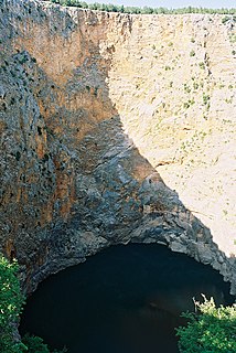
Red Lake is a sinkhole containing a karst lake near the city of Imotski, Croatia. It is known for its numerous caves and remarkably high cliffs, reaching over 241 metres above normal water level and continuing below the water level. The total explored depth of this sinkhole is approximately 530 metres with a volume of roughly 25–30 million cubic metres, thus it is the third largest sinkhole in the world. Water drains out of the basin through underground waterways that descend below the level of the lake floor. The deepest known point of the lake is 4 metres below sea level.

Piccaninnie Ponds Conservation Park, formerly the Piccaninnie Ponds National Park, is a protected area of 862 hectares located in southeastern South Australia near Mount Gambier.

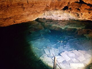
Ewens Ponds is a series of three water-filled limestone sinkholes in the Australian state of South Australia located in the gazetted locality of Eight Mile Creek, on the watercourse of Eight Mile Creek about 25 kilometres south of Mount Gambier and 8.4 kilometres east of Port Macdonnell. The ponds are popular with recreational divers due to underwater visibility of up to 80 metres. It has a large fish population including the endangered golden pygmy perch. Ewens Ponds has been part of the Ewens Ponds Conservation Park since 1976.
Kybybolite is a locality in the Australian state of South Australia located in the state's south-east within the Limestone Coast region on the border with the state of Victoria about 301 kilometres south east of the state capital of Adelaide and about 19 kilometres north-east of the municipal seat of Naracoorte.
The Cave Divers Association of Australia (CDAA) is a cave diving organisation which was formed in September 1973 to represent the interests of recreational scuba divers who dive in water‐filled caves and sinkholes principally in the Lower South East of South Australia (SA) and secondly in other parts of Australia. Its formation occurred after a series of diving fatalities in waterfilled caves and sinkholes in the Mount Gambier region between 1969 and 1973 and in parallel to a South Australian Government inquiry into these deaths. The CDAA's major achievement has been the dramatic reduction of fatalities via the introduction of a site rating scheme and an associated testing system which was brought in during the mid-1970s. While its major area of operation is in the Limestone Coast region of SA, it administers and supports cave diving activity in other parts of Australia including the Nullarbor Plain and Wellington, New South Wales.
Little Blue Lake is a water-filled doline in the Australian state of South Australia located in the state's south-east in the locality of Mount Schank about 20 kilometres (12 mi) south of the municipal seat of Mount Gambier. It is notable locally as a swimming hole and nationally as a cave diving site. It is managed by the District Council of Grant and has been developed as a recreational and tourism venue.

Fossil Cave (5L81), formerly known as The Green Waterhole, is a cave in the Limestone Coast region of south-eastern South Australia. It is located in the gazetted locality of Tantanoola about 22 kilometres north-west of the city of Mount Gambier, only a few metres from the Princes Highway between Mount Gambier and Millicent. It is popular with cave divers and is notable for being both a unique paleontological site and the "type locality" for very rare crustaceans which to date have been found only in caves and Blue Lake in the Mount Gambier region.
Engelbrecht Cave is a cave system in the Australian state of South Australia consisting of a sinkhole with two major passages located under the Mount Gambier urban area. It is owned by the local government area of City of Mount Gambier and has been developed as a tourism venue. Its dry extent is notable as a show cave while its water-filled extent is notable as two separate cave diving sites.
The Kilsby sinkhole is a sinkhole located near Mount Gambier in South Australia. Since the late 1960s, the naturally occurring karst sinkhole has been used for recreational diving as well as civilian and police diver training.
The 1973 Mount Gambier cave diving accident was a scuba diving incident in 1973 at a flooded sinkhole known as "The Shaft" near Mount Gambier in South Australia. The incident claimed the lives of four recreational scuba divers: siblings Stephen and Christine M. Millott, Gordon G. Roberts, and John H. Bockerman. The four divers explored beyond their own planned limits, without the use of a guideline, and subsequently became lost, eventually exhausting their breathing air and drowning. As of May 2015, they are the only known fatalities at the site. Four other divers from the same group survived.

