Telford Scrub Conservation Park

Last updated

Telford Scrub Conservation Park
South Australia
Australia South Australia relief location map.png
Red pog.svg
Telford Scrub Conservation Park
Nearest town or city Mount Gambier [2]
Coordinates 37°41′49″S140°47′11″E / 37.6969°S 140.7864°E / -37.6969; 140.7864 Coordinates: 37°41′49″S140°47′11″E / 37.6969°S 140.7864°E / -37.6969; 140.7864
Established12 March 1987 (1987-03-12) [3]
Area1.7 km2 (0.7 sq mi) [4]
Managing authorities Department for Environment and Water
Website Telford Scrub Conservation Park
See also Protected areas of South Australia

Telford Scrub Conservation Park is a protected area in the Australian state of South Australia located in the state's Limestone Coast in the gazetted locality of Dismal Swamp about 14 kilometres (8.7 mi) north of the city centre in Mount Gambier. [5]

Protected area location which receives protection because of its recognised natural, ecological or cultural landscape values

Protected areas or conservation areas are locations which receive protection because of their recognized natural, ecological or cultural values. There are several kinds of protected areas, which vary by level of protection depending on the enabling laws of each country or the regulations of the international organizations involved.

South Australia State of Australia

South Australia is a state in the southern central part of Australia. It covers some of the most arid parts of the country. With a total land area of 983,482 square kilometres (379,725 sq mi), it is the fourth-largest of Australia's states and territories by area, and fifth largest by population. It has a total of 1.7 million people, and its population is the second most highly centralised in Australia, after Western Australia, with more than 77 percent of South Australians living in the capital, Adelaide, or its environs. Other population centres in the state are relatively small; Mount Gambier, the second largest centre, has a population of less than 30,000.

Limestone Coast Region in South Australia

The Limestone Coast is a name used since the early twenty-first century for a South Australian government region located in the south east of South Australia which immediately adjoins the continental coastline and the Victorian border. The name is also used for a tourist region and a wine zone both located in the same part of South Australia.

Contents

The conservation park occupies land in section 134 of the cadastral unit of the Hundred of Young to the west of the Riddoch Highway. It is bounded by Grundys Lane to the south with access for visitors provided by a 5 metres (16 ft) wide vehicle track to the inside of its boundaries. In 1992, it was bounded on three sides by land using for grazing while the land south of Grundy Lane was used as a pine plantation. A facility known as the Pine Lodge Holiday Camp is located to the immediate east of its north eastern corner. Its name is derived from the former owners, the Telford family. [5] [2]

Lands administrative divisions of South Australia

The lands administrative divisions of South Australia are the cadastral units of counties and hundreds in South Australia. They are located only in the south-eastern part of the state, and do not cover the whole state. A total of 540 hundreds have been proclaimed, although five were annulled in 1870, and, in some cases, the names reused elsewhere.

Riddoch Highway highway in South Australia

The Riddoch Highway in south-eastern South Australia branches from the Dukes Highway at Keith and travels south through Padthaway, Naracoorte, Penola, Nangwarry, Tarpeena, and Mount Gambier to Port MacDonnell and nearby Cape Northumberland.

The conservation park was proclaimed on 12 March 1987 with access permitted for the purpose of petroleum exploration under the Petroleum Act 1940. [3] As of July 2016, the conservation park covered an area of 1.7 square kilometres (0.66 sq mi). [4]

In 1992, the conservation park was described as consisting of “a series of sand ridges overlying limestone, giving way to low lying wetlands in the southern and eastern sections.” It supports the following major vegetation associations: [2]

  1. an “open woodland” of brown stringybark,
  2. an association which covers most of the conservation park and consists of an “open woodland” of brown stringybark and rough barked manna gum with isolated stands of blackwood, silver banksia and native box over an understorey of bracken,
  3. an association which dominates the southern end of the conservation park and consists of an “open woodland” of swamp gum with an understorey consisting of heath tea-tree, bottlebrush tea-tree, sword-sedge and rushes.
  4. a “low open shrubland dominated by tea-tree …, heath tea-tree …, sedges … and rushes …”

The conservation park was also reported in 1992 as having a “rich faunal population including a population of short-nosed bandicoot.” [2]

Southern brown bandicoot species of mammal

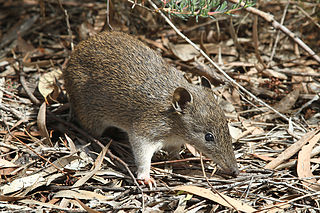
The southern brown bandicoot is a short-nosed bandicoot, a type of marsupial, found mostly in southern Australia. It is also known as the quenda in South Western Australia.

As of 1992, visitors to the conservation park consisted of “local residents, school groups, and guests at Pine Lodge Holiday Camp.” [2]

The conservation park is classified as an IUCN Category III protected area. [1]

See also

Related Research Articles

Fairview Conservation Park Protected area in South Australia

Fairview Conservation Park is a protected area in the Australian state of South Australia located in the gazetted locality of Woolumbool about 17 kilometres (11 mi) north of Lucindale in the state's Limestone Coast region.

Mount Magnificent Conservation Park Protected area in South Australia

Mount Magnificent Conservation Park is a protected area in the Australian state of South Australia located in the Mount Lofty Ranges about 58 kilometres south of the state capital of Adelaide. It is located within the gazetted locality of Mount Magnificent.

Gum Lagoon Conservation Park Protected area in South Australia

Gum Lagoon Conservation Park is an 8765 ha protected area about 40 km south-west of Keith in the Limestone Coast region of South Australia. It lies about 20 km inland from the southern end of the Coorong. It contains an isolated block of mallee woodland important for malleefowl conservation.

Waitpinga Conservation Park Protected area in South Australia

Waitpinga Conservation Park is a protected area in the Australian state of South Australia located about 15 kilometres south of the town of the Yankalilla in the gazetted locality of Parawa.

Desert Camp Conservation Reserve Protected area in South Australia

Desert Camp Conservation Reserve is a protected area in the Australian state of South Australia located in the state's Limestone Coast in the gazetted locality of Marcollat about 44 kilometres (27 mi) south of the town centre in Keith. It is classified as an IUCN Category VI protected area.

Wanilla Conservation Park Protected area in South Australia

Wanilla Conservation Park is a protected area located in the Australian state of South Australia on the Eyre Peninsula in the gazetted locality of Wanilla about 4 kilometres east of the Wanilla town centre.

Tucknott Scrub Conservation Park Protected area in South Australia

Tucknott Scrub Conservation Park is a protected area located in the Australian state of South Australia on the Eyre Peninsula in the gazetted locality of Whites Flat about 12 kilometres north-east of the town centre in Wanilla and about 30 kilometres north of the municipal seat of Port Lincoln.

Talapar Conservation Park Protected area in South Australia

Talapar Conservation Park is a protected area in the Australian state of South Australia located in the state's Limestone Coast in the gazetted locality of Keppoch about 40 kilometres (25 mi) north-west of the town centre in Naracoorte.

Grass Tree Conservation Park Protected area in South Australia

Grass Tree Conservation Park is a protected area in the Australian state of South Australia located in the state's Limestone Coast in the gazetted locality of Cadgee about 17 kilometres (11 mi) north of the town centre in Naracoorte.

Big Heath Conservation Park Protected area in South Australia

Big Heath Conservation Park is a protected area in the Australian state of South Australia located in the gazetted locality of Spence about 20 kilometres (12 mi) south-west of Naracoorte in the state's Limestone Coast region.

Bangham Conservation Park Protected area in South Australia

Bangham Conservation Park is a protected area in the Australian state of South Australia located in the state's Limestone Coast in the gazetted locality of Bangham about 45 kilometres (28 mi) north-east of the town centre in Naracoorte.

Pine Hill Soak Conservation Park Protected area in South Australia

Pine Hill Soak Conservation Park is a protected area in the Australian state of South Australia located in the state's Limestone Coast in the gazetted locality of Bangham about 30 kilometres (19 mi) south of the town centre in Bordertown.

Penambol Conservation Park Protected area in South Australia

Penambol Conservation Park is a protected area in the Australian state of South Australia located in the state's south-east in the gazetted locality of Caroline about 22 kilometres (14 mi) south-east of the city centre in Mount Gambier.

Mary Seymour Conservation Park Protected area in South Australia

Mary Seymour Conservation Park is a protected area in the Australian state of South Australia located in the south-east of the state in the gazetted locality of Bool Lagoon about 25 kilometres (16 mi) south-west of the town centre of Naracoorte.

Gower Conservation Park Protected area in South Australia

Gower Conservation Park is a protected area located in the Australian state of South Australia in the locality of Tantanoola about 353 kilometres (219 mi) south-east of the state capital of Adelaide and about 25 kilometres (16 mi) north west of the regional city of Mount Gambier.

Furner Conservation Park Protected area in South Australia

Furner Conservation Park is a protected area located in the Australian state of South Australia in the locality of Furner about 310 kilometres (190 mi) south-east of the state capital of Adelaide and about 27 kilometres (17 mi) north west of the municipal seat of Millicent.

Calectasia Conservation Park Protected area in South Australia

Calectasia Conservation Park, formerly the Calectasia National Parks Reserve, is a protected area located in the Australian state of South Australia in the locality of Wattle Range about 320 kilometres (200 mi) south-east of the state capital of Adelaide and about 25 kilometres (16 mi) west of the town of Penola.

Penola Conservation Park Protected area in South Australia

Penola Conservation Park is a protected area located in the Australian state of South Australia in the locality of Monbulla about 329 kilometres (204 mi) south-east of the state capital of Adelaide and about 12 kilometres (7.5 mi) west of the town of Penola.

Geegeela Conservation Park Protected area in South Australia

Geegeela Conservation Park is a protected area in the Australian state of South Australia located in the state's south-east in the gazetted locality of Bangham about 277 kilometres (172 mi) north-west of the state capital of Adelaide and about 12 kilometres (7.5 mi) north-west of the town centre in Frances.

Padthaway Conservation Park Protected area in South Australia

Padthaway Conservation Park is a protected area in the Australian state of South Australia located in the state's south-east in the gazetted locality of Padthaway about 253 kilometres (157 mi) south-east of the state capital of Adelaide and about 2.5 kilometres (1.6 mi) north-east of the locality's town centre.

References

  1. 1 2 "Terrestrial Protected Areas of South Australia (refer 'DETAIL' tab )". CAPAD 2016. Australian Government, Department of the Environment (DoE). 2016. Retrieved 21 February 2018.
  2. 1 2 3 4 5 South Australia. National Parks and Wildlife Service. South East District; Sutherland, Andrea; South Australia. National Parks and Wildlife Service (1992), Small parks of the upper South East management plans, South East, South Australia (PDF), Dept. of Environment and Planning, pp. 32–34, ISBN   978-0-7308-2665-1
  3. 1 2 "NATIONAL PARKS AND WILDLIFE ACT, 1972, SECTIONS 30 AND 43: TELFORD SCRUB CONSERVATION PARK CONSTITUTED" (PDF). The South Australian Government Gazette. Government of South Australia: 594. 12 March 1987. Retrieved 22 March 2017.
  4. 1 2 "Protected Areas Information System - reserve list (as of 11 July 2016)" (PDF). Department of Environment Water and Natural Resources. 11 July 2016. Retrieved 14 July 2016.
  5. 1 2 "Search result(s) for Telford Scrub Conservation Park (Record No. SA0065854) with the following layers being selected - "Parcel labels", "Suburbs and Localities", "Hundreds", "Place names (gazetteer)" and "Road labels"". Property Location Browser. Government of South Australia. Retrieved 22 March 2017.