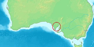
Billiatt Conservation Park is a protected area in South Australia midway between Alawoona and Lameroo, approximately 200 km east of Adelaide city centre.

Hacks Lagoon Conservation Park is a protected area in the Australian state of South Australia located in the locality of Bool Lagoon about 24 kilometres south of the municipal seat of Naracoorte.

Nuyts Archipelago Conservation Park is a protected area in the Australian state of South Australia located on Eyre Island and St Peter Island in the Nuyts Archipelago located off the west coast of Eyre Peninsula about 10 kilometres south and 25 kilometres south-east respectively of Ceduna.

Isles of St Francis Conservation Park was a protected area in the Australian state of South Australia located on islands within the Isles of St Francis off the west coast of Eyre Peninsula about 562 kilometres (349 mi) north-west of the state capital of Adelaide and about 50 kilometres (31 mi) south-west of the town of Ceduna.

The Pages Conservation Park is a protected area in the Australian state of South Australia which is associated with the island group known as The Pages located in Backstairs Passage about 25 kilometres south-east of Cape Jervis and about 98 kilometres south south-west of the state capital of Adelaide.

Pullen Island Conservation Park is a protected area includes all of Pullen Island about 0.5 kilometres south of Port Elliot in South Australia and about 94 kilometres south of Adelaide.

Pelican Lagoon Conservation Park is a protected area located in the Australian state of South Australia on the Dudley Peninsula on Kangaroo Island. It was dedicated in 1967 for the protection of wildlife habitat.

Waldegrave Islands Conservation Park is a protected area located on the following islands within the Investigator Group in South Australia: the Waldegrave Island, Little Waldegrave Island and the Watchers.

Nuyts Reef Conservation Park is a protected area in the Australian state of South Australia associated with Nuyts Reef which is located off the state's west coast in the Great Australian Bight about 29 kilometres west south-west of Fowlers Bay.

Baird Bay Islands Conservation Park is a protected area in the Australian state of South Australia associated with two islands located in Baird Bay on the west coast of Eyre Peninsula respectively about 32 kilometres and 45 kilometres west south-west of Streaky Bay.

Olive Island Conservation Park is a protected area in the Australian state of South Australia associated with Olive Island off the west coast of Eyre Peninsula and which is located about 25 kilometres west-northwest of the town of Streaky Bay.

Lipson Island Conservation Park is a protected area in the Australian state of South Australia associated with Lipson Island in Spencer Gulf about 12 kilometres north northeast of Lipson.

Pigface Island Conservation Park is a protected area in the Australian state of South Australia associated with Pigface Island located in Streaky Bay on the west coast of Eyre Peninsula about 13 kilometres north north-east west of the town of Streaky Bay.

Kellidie Bay Conservation Park is a protected area in the Australian state of South Australia, located on the west coast of Eyre Peninsula immediately east of the town centre in Coffin Bay and immediately adjoining the south coast of Kellidie Bay in the localities of Coffin Bay, Kellidie Bay and Wangary.

Mount Dutton Bay Conservation Park is a protected area in the Australian state of South Australia located on the west coast of Eyre Peninsula on islands located on waters in the sector between the north west to the east of the town of Coffin Bay.

Wittelbee Conservation Park, formerly the Wittelbee National Park, is a protected area in the Australian state of South Australia located on the west coast of Eyre Peninsula in adjoining the headland of Wittelbee Point about 10 kilometres south east of the town of Ceduna.

Calpatanna Waterhole Conservation Park is a protected area in the Australian state of South Australia located on the Eyre Peninsula in the gazetted localities of Calca, Mortana and Yanerbie about 25 kilometres (16 mi) south-east of the town centre in Streaky Bay.

Media Island Conservation Park is a protected area in the Australian state of South Australia located in the Riverland in the gazetted locality of Loxton about 3 kilometres (1.9 mi) north-east of the Loxton town centre.

Rilli Island Conservation Park is a protected area in the Australian state of South Australia located on the Riverland in the gazetted locality of Loxton North about 6.5 kilometres (4.0 mi) north-east of the Loxton town centre.

Kapunda Island Conservation Park is a protected area in the Australian state of South Australia located on the Riverland in the gazetted locality of Loxton about 1 kilometre (0.62 mi) north-west of the Loxton town centre.


