
List of protected areas in Adelaide refers to protected areas proclaimed by South Australian government which are located within the Adelaide metropolitan area. [1]
List of protected areas in Adelaide refers to protected areas proclaimed by South Australian government which are located within the Adelaide metropolitan area. [1]
The following protected areas are located within the South Australian government region known as Northern Adelaide. [2] [3]
The following protected areas are located within the South Australian government region known as Western Adelaide. [7] [3]
The following protected areas are located within the South Australian government region known as Eastern Adelaide. [8] [3]
The following protected areas are located within the South Australian government region known as Southern Adelaide. [9] [3]

Protected areas of South Australia consists of protected areas located within South Australia and its immediate onshore waters and which are managed by South Australian Government agencies. As of March 2018, South Australia contains 359 separate protected areas declared under the National Parks and Wildlife Act 1972, the Crown Land Management Act 2009 and the Wilderness Protection Act 1992 which have a total land area of 211,387.48 km2 (81,617.16 sq mi) or 21.5% of the state's area.

Onkaparinga River Recreation Park is a protected area occupying land in the estuary of the Onkaparinga River in South Australia. The recreation park which was established in 1985 is approximately 32 km (20 mi) from Adelaide city centre. It is the venue for recreational activities such as walking, canoeing, kayaking, recreational fishing and picnics.
The Onkaparinga River, known as Ngangkiparri or Ngangkiparingga in the Kaurna language, is a river located in the Southern Adelaide region in the Australian state of South Australia. Rising in the Mount Lofty Ranges, the river's estuary extends from Old Noarlunga to the river's mouth between the suburbs of Port Noarlunga and Port Noarlunga South.

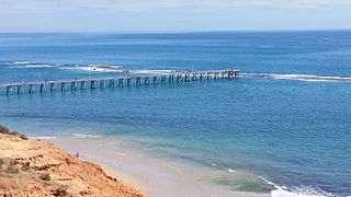
Port Noarlunga is a suburb in the City of Onkaparinga, South Australia. It is a small sea-side suburb, with a population of 2,918, about 30 kilometres to the south of the Adelaide city centre and was originally created as a sea port. This area is now popular as a holiday destination or for permanent residents wishing to commute to Adelaide or work locally. There is a jetty that connects to a 1.6 kilometres long natural reef that is exposed at low tide. The beach is large and very long and has reasonable surfing in the South Port area whose name is taken from its location - "South of the Port".

The Barker Inlet is a tidal inlet of the Gulf St Vincent in Adelaide, South Australia, named after Captain Collet Barker who first sighted it in 1831. It contains one of the southernmost mangrove forests in the world, a dolphin sanctuary, seagrass meadows and is an important fish and shellfish breeding ground. The inlet separates Torrens Island and Garden Island from the mainland to the east, and is characterised by a network of tidal creeks, artificially deepened channels, and wide mudflats. The extensive belt of mangroves are bordered by samphire saltmarsh flats and low-lying sand dunes.

Aldinga Beach is an outer southern suburb of Adelaide, South Australia. It lies within the City of Onkaparinga and has the postcode 5173. At the 2016 census, Aldinga Beach had a population of 10,557. It lies about a kilometre west of the smaller suburb of Aldinga. The beach is a well-known spot for surfing, swimming, scuba diving, and snorkelling during the summer months. It overlooks an aquatic reserve which has been created to safeguard a unique reef formation.

Para Wirra Conservation Park is a 1,417-hectare (3,500-acre) protected area located in the foothills of the Mount Lofty Ranges in the northern end of the Adelaide metropolitan area in South Australia. The conservation park is part of a larger, 2,573-hectare (6,360-acre) block of contiguous native vegetation, the remainder of which is owned by PIRSA Forestry, SA Water and private landholders.

Torrens Island is an island in the Australian state of South Australia located in the Adelaide metropolitan area in the Port River Estuary about 15 kilometres (9.3 mi) northwest of the Adelaide city centre. Since European settlement of Adelaide in 1836, it has been used for a number of purposes.
Port Gawler Conservation Park was a protected area in the Australian state of South Australian located at the east side of Gulf St Vincent on the west side of the locality of Port Gawler. The conservation park covered an area of intertidal mangroves immediately south of Port Gawler beach.
Torrens Island Conservation Park is a protected area in the Australian state of South Australia located on Torrens Island in the Adelaide metropolitan area about 17 kilometres north-northwest of the state capital of Adelaide and about 3.9 kilometres north-northeast of Port Adelaide.

Aldinga Bay is a bay located on the east coast of Gulf St Vincent in South Australia about 40 kilometres south-southwest of Adelaide city centre.

The Adelaide International Bird Sanctuary National Park—Winaityinaityi Pangkara is a protected area in South Australia established by the South Australian government on the northeast coast of Gulf St Vincent, between Parham in the north and the southern end of Barker Inlet in the south, for the purpose of rehabilitating land used as salt pans, protecting habitat for international migratory shorebirds, managing water quality in adjoining parts of Gulf St Vincent, creation of "green" space, development of niche tourism and creation of opportunities for Indigenous people.
Port Noarlunga Reef Aquatic Reserve is a marine protected area in the Australian state of South Australia located in waters in Gulf St Vincent adjoining the Adelaide metropolitan area and including part of the Onkaparinga River about 28 kilometres (17 mi) south-west of the state capital of Adelaide.
Garden Island is an island in the Australian state of South Australia located about 14 kilometres (8.7 mi) north-west of the capital city of Adelaide in an estuary system within the Adelaide metropolitan area which drains into Gulf St Vincent. It is notable as being a site for a mangrove forest, a landfill, a part of the site for the Multifunction Polis, a ship graveyard and a venue for recreational boating activities. It has enjoyed varying degrees of protected area status since 1973.

American River Aquatic Reserve was a marine protected area in the Australian state of South Australia located on the north coast of Kangaroo Island in waters of the coastal lagoon known as Pelican Lagoon, in existence from 1971 to 2016. From 2012, the Pelican Lagoon Sanctuary Zone has fallen within the Encounter Marine Park. Pelican Lagoon is probably the oldest marine protected area in South Australia, having been protected since 1914.
Aldinga Reef Aquatic Reserve is a marine protected area in the Australian state of South Australia located in waters adjoining the east coast of Gulf St Vincent including land within the intertidal zone in the suburbs of Aldinga Beach and Port Willunga about 40 kilometres (25 mi) south of the state capital of Adelaide.
Barker Inlet – St Kilda Aquatic Reserve is a marine protected area in the Australian state of South Australia located in waters adjoining the east coast of Gulf St Vincent in Barker Inlet about 16 kilometres (9.9 mi) north of the state capital of Adelaide.
St Kilda – Chapman Creek Aquatic Reserve is a marine protected area in the Australian state of South Australia located in waters on the east coast of Gulf St Vincent adjoining the suburbs of Buckland Park and St Kilda about 24.8 kilometres (15.4 mi) north of the state capital of Adelaide.

Adelaide Dolphin Sanctuary (ADS) is a marine protected area in the Australian state of South Australia located on the east coast of Gulf St Vincent in and adjoining the north-western part of Adelaide, covering the estuary of the Port River around Port Adelaide and northwards past St Kilda. It was established in 2005 for the protection of a resident population of Indo-Pacific bottlenose dolphins.