"},"force_national_map":{"wt":""},"relief":{"wt":"yes"},"pushpin_map_caption":{"wt":""},"pushpin_label_position":{"wt":"left"},"map_alt":{"wt":""},"nearest_town_or_city":{"wt":""},"area":{"wt":"2.66"},"area_footnotes":{"wt":"{{cite web|title=Protected Areas Information System - reserve list (as of 16 July 2015)|url= http://www.environment.sa.gov.au/files/sharedassets/public/park_management/protected-areas-30june2015.pdf |publisher=Department of Environment Water and Natural Resources|access-date=3 August 2015}}"},"established":{"wt":"{{start date|1989|10|26|df=y}}"},"established_footnotes":{"wt":"{{cite web |last1=Blevins |first1=F.T. |title=NATIONAL PARKS AND WILDLIFE ACT, 1972, SECTION 34 (1): CONSTITUTION OF COBBLER CREEK RECREATION PARK |url=http://www8.austlii.edu.au/au/other/sa_gazette/1989/89/1298.pdf |website=The South Australian Government Gazette |publisher=Government of South Australia |access-date=8 June 2019 |page=1298 |date=26 October 1989}}"},"visitation_num":{"wt":""},"visitation_year":{"wt":""},"visitation_footnotes":{"wt":""},"managing_authorities":{"wt":"[[Department for Environment and Water (South Australia)|Department for Environment and Water]]"},"url":{"wt":"http://www.environment.sa.gov.au/parks/Find_a_Park/Browse_by_region/Adelaide/Cobbler_Creek_Recreation_Park"}},"i":0}}]}" id="mwBw">Protected area in South Australia
Cobbler Creek Recreation Park Salisbury East, South Australia | |
---|---|
![]() Cobbler Creek Recreation Park | |
Coordinates | 34°46′46.56″S138°41′27.23″E / 34.7796000°S 138.6908972°E [1] |
Established | 26 October 1989 [2] |
Area | 2.66 km2 (1.0 sq mi) [3] |
Managing authorities | Department for Environment and Water |
Website | Cobbler Creek Recreation Park |
See also | Protected areas of South Australia |
Cobbler Creek Recreation Park is a 266-hectare (657-acre) protected area located in South Australia about 19 kilometres (12 mi) north of the Adelaide city centre in the suburb of Salisbury East. Originally part of the lands of the Kaurna aboriginal people, it was farmed from European settlement of South Australia until the declaration of the park in 1989.
The park provides an open space barrier between Golden Grove and the suburbs of Salisbury, has dams to mitigate flooding and is a significant site for both public recreation and native flora and fauna conservation. It is bounded by main roads and bisected by a four-lane main connecting road.
Cobbler Creek Recreation Park is a 266-hectare (657-acre) protected area located about 19 kilometres (12 mi) north of the Adelaide city centre within the suburb of Salisbury East. [4] The park is bounded by Bridge and Smith roads, and Green Valley Drive. The Grove Way, a major divided road, runs through the park with a pedestrian underpass connecting the two park sections. The park is open to the public and includes three formed walking trails and two ruins. The remains of William Pedler's home "Trevalsa" and another's called "Teakles House" lie next to one of the trails. There are no public facilities except for benches, signage and picnic tables. [5] "Kelway House", originally belonging to the Kelway Park farm that occupied much of the park, remains as office accommodation for park management staff. [6]
The park lies on the border between the dry northern Adelaide Plains and the wetter Mount Lofty Ranges. Based on climate measurements for nearby Parafield Airport, the park has an average rainfall of 465 millimetres (18 in), an average winter daily temperature range of 6.2—15.6 degrees Celsius and a summer range of 16.5—29.7. [7] Due to the risk of flooding after heavy rain, the park's waterways have been dammed, though they are dry for much of the year. [8] The park's topography ranges from steadily sloping in the west, to hilly in the east. Its lowest point, on the western edge along Bridge road, is 70 metres (230 ft) above sea level, rising to 215 metres (705 ft) at the Para Trigonometric Point in the park's southeastern corner. Flat land on the western side has red-brown soil with the remainder having Terra Rosas, Redzinas and fine-textured mallee soils. [9]
Cobbler Creek itself begins in the hills to the west of Golden Grove and joins with Slate Creek prior to entering the park. It is used to collect stormwater from the Tea Tree Gully area as it passes through both farmland and suburbs. After leaving the park the creek passes through housing developments, into wetlands and eventually to the Barker Inlet. [10]
The recreation park is classified as an IUCN Category III protected area. [1]
After European settlement the land was used for farming. William Pedler III (1804–1874), emigrated to the colony from Cornwall in 1838. He was one of the first to farm the area with his wife Elizabeth (Nicholls). William had been a shoe-maker in Cornwall and Adelaide and from his farm at Salisbury made shoes and boots for teamsters passing through carting ore to Burra. William Pedler first purchased land of 66 acres (27 ha) at Cobbler Creek in 1850, later adding adjoining land to create a farm of 279 acres. He passed the property on, and his oldest son William IV farmed the land for many years with his wife Martha (Day) and their family. [11] William III's profession gave both the creek that passes through the northern part of the park, and the park their names. [12] Pedler's farm occupied the flatter, western area of land near Bridge Road. Part of the park was later a farm known as "Kelway Park"; a homestead of the same name remains in the park's south-west. In the 19th century, Salisbury residents used this area for Sunday school picnics. Swings were temporarily built, water and food brought to the site and games and bands provided for entertainment. [13]
Investigations have found no evidence of land use prior to European settlement, although the park forms part of the traditional lands of the Kaurna aboriginal people. [7] It is likely that the Kaurna used the area during winter for food and shelter, moving to the coast to escape summer heat. [14]
In a 1962 government report, the park's area was identified for use as future open space. A golf course was proposed, as were other sporting facilities. The course was re-proposed in 1981 and again in the 1990 management plan. The park was purchased by the Government of South Australia in 1970, as part of a program preserving open space for recreation. The park's location was chosen to provide a development-free buffer between the existing suburbs of Salisbury and the proposed Golden Grove development. It was owned and managed by the State Planning Authority until 1982 when control passed to the National Parks and Wildlife Service. Cobbler Creek was declared a recreation park in 1989, at which point some of the land remained leased for agriculture. [15] The Golden Grove Indenture Act (1984) committed the government to build certain access roads to the new suburb of Golden Grove. Based on the provisions of section 7A-1 in the act, in June 1987 cabinet approved the building of Grove Way. The road is a 4-lane divided connecting road, begun in September 1988 and completed in 1990. [16]
Cobbler Creek Recreation Park is administered and maintained jointly by the City of Salisbury, and the Department of Environment, Water and Natural Resources. A volunteer group, Friends of Cobbler Creek, was formed in 1990 and works with rangers to improve and maintain the park. [17]
While sections of the park have been cleared (owing to past land uses), other areas feature grassland, river red gum ( Eucalyptus camaldulensis ), and mallee box ( Eucalyptus porosa ). The park contains some of the last remaining mallee box grassy woodland in Adelaide. Amongst the woodlands, plants like the blue-flowering flax lily are common. [14]
Most of the lower, western parts of the park were cleared for pasture and cropping until the early 1970s. While there is remnant vegetation on higher ground, introduced pasture grasses and associated weeds dominate much of the understorey. [9] Perennial native grasses, such as kangaroo grass ( Themeda triandra ), have been used as part of the park's revegetation. Many of the introduced grasses dry in summer and pose a greater fire hazard than the regrowth. To combat this hazard, and protect surrounding residential areas, annual burns are held particularly around the park's margins. These burns also serve to encourage native vegetation to dominate over introduced weeds. [14]
Due to the park's perceived modest conservation values, the 1990 management plan called only for specific control of proscribed weeds rather than an eradication plan for all introduced species. [18] Cobbler Creek park has a wide range of native plants including quandong, ruby saltbush ( Enchylaena tomentosa ), desert cassia ( Cassia eremophila ), weeping pittosporum and umbrella wattle ( Acacia ligulata ). [14]
Native fauna species have been greatly reduced by past agricultural practices and the introduced rabbit is now common. [19] Eastern bearded dragons, White's skink, eastern brown snake, and sleepy lizard reptile species are seen; a total of twenty species have been seen within the park. [20] Black-shouldered kites and nankeen kestrels hunt over the grasslands. red-rumped parrots and crested pigeons are seen feeding on the ground and wattlebirds, musk lorikeets, noisy miners and honeyeaters in the flowering gums and along creeklines. [14] The park is home to a small population of the worm-like and vulnerable Flinders Ranges worm-lizard (Aprasia pseudopulchella). [21]
Recreational use of the park is encouraged. There are some picnic facilities provided and dogs are allowed to be walked while on leads. The park includes three named walking trails—Mai Tappa, Babbler and Porosa— that largely follow formed management tracks. The trails pass by the park's ruins and both these and natural sights are highlighted by interpretive signs. [14]
Mountain bike riding was prohibited within the park and illegal trail bike riding was common. [22] However, as of 2013 shared use trails have been built for walkers and mountain bike riders.
Belair National Park is a protected area in Belair, South Australia, 9 kilometres southeast of Adelaide city centre; it covers an area of 835 hectares. It was proclaimed in 1891 and was the first national park in South Australia, second in Australia and the tenth in the world. The national park lies within the Adelaide Hills and Mitcham council area, and forms part of a chain of protected areas located along the Adelaide Hills Face Zone. The national park is administered by the Department of Environment, Water and Natural Resources.
Onkaparinga River National Park is a protected area in the Australian state of South Australia located about 32 kilometres (20 mi) south of Adelaide city centre. It extends over the floodplain of the Onkaparinga River east of Main South Road.
Brown Hill Creek, also known as Willawilla in the Kaurna language, is a watercourse flowing from the Adelaide Hills through in the inner south suburbs of the Adelaide metropolitan area, in the Australian state of South Australia. It is part of the Patawalonga River catchment.
Onkaparinga River Recreation Park is a protected area occupying land in the estuary of the Onkaparinga River in South Australia. The recreation park which was established in 1985 is approximately 32 km (20 mi) from Adelaide city centre. It is the venue for recreational activities such as walking, canoeing, kayaking, recreational fishing and picnics.
Gulfview Heights is a small suburb of Adelaide, South Australia and is within the City of Salisbury and City of Tea Tree Gully local government area. It is adjacent to Wynn Vale, Salisbury East and Para Hills.
Wynn Vale is an outer north-eastern suburb of Adelaide, South Australia and is located within the City of Tea Tree Gully local government area. It is adjacent to Golden Grove, Modbury Heights, Surrey Downs, Salisbury East and Para Hills. It is located approximately 20 km north-east of the city of Adelaide.
O'Halloran Hill is a suburb in the south of Adelaide, South Australia, situated on the hills south of the O'Halloran Hill Escarpment, which rises from the Adelaide Plains and located 18 km from the city centre via the Main South Road. The suburb is split between the Cities of Marion and Onkaparinga, and it neighbours Happy Valley, Hallett Cove, Trott Park and Darlington. It includes a large area of farmland and commercial vineyards known as the Glenthorne Estate.
Greenwith is an outer-north-eastern suburb of Adelaide, the capital city of South Australia, and is within the City of Tea Tree Gully local government area. It is adjacent to Golden Grove and Salisbury Heights. Greenwith is the northernmost part of the Golden Grove urban land development.
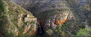
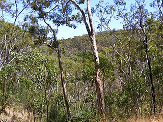
Morialta Conservation Park, formerly the Morialta Falls Reserve and the Morialta Falls National Pleasure Resort, is a protected area 10 km north-east of Adelaide city centre, in the state of South Australia, Australia. The park is in a rugged bush environment, with a narrow gorge set with three waterfalls, bounded by steep ridges and cliffs. The park caters to many activities, including bushwalking, bird watching and rock climbing.
Totness Recreation Park is a protected area in the Australian state of South Australia located within the localities of Mount Barker and Totness in the central Mount Lofty Ranges. Covering 41 hectares of land, the park is divided by the South Eastern Freeway and features a large dam. It was declared as a reserve in 1970 and re-designated as a recreation park in 1972. The park has no visitor facilities except for access tracks. It is the only park in the district, managed by the Department of Environment and Water, that is solely designated for recreation.
Black Hill Conservation Park, formerly the Black Hill National Park, is a protected area in the Australian state of South Australia located approximately 10 kilometres (6.2 mi) northeast of the state capital of Adelaide. The conservation park is in a rugged bush environment, with a prominent peak, bounded by steep ridges on the southern slopes.
Moana is an outer coastal suburb in the south of Adelaide, South Australia. The suburb is approximately 36.4 km from the Adelaide city centre. It lies within the City of Onkaparinga local government area, and neighbours the suburbs Seaford, Maslin Beach, Seaford Rise and Port Noarlunga It is divided into two by Pedler Creek and the associated sand dune reserve. The beach is often referred to as Moana Beach.
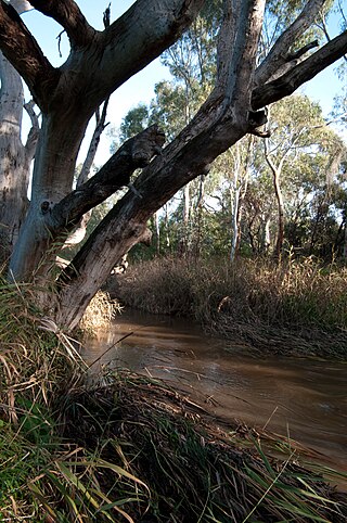
The Sturt River, also known as the Sturt Creek and Warri Parri (Warriparri) in the Kaurna language, is a river located in the Adelaide region of the Australian state of South Australia.
Anstey Hill Recreation Park is a 362-hectare (890-acre) protected area established in 1989 and located approximately 19 kilometres (12 mi) northeast of Adelaide, South Australia. The park is a significant reserve of bushland in the foothills of the Mount Lofty Ranges and is home to rare or vulnerable native plants and animals, and problematic invasive species. It is managed by the City of Tea Tree Gully, the Department of Environment, Water and Natural Resources and a volunteer group—The Friends of Anstey Hill. The park is designed for recreational walking and has no visitor facilities. It is managed in association with the regional planning initiative known as of Yurrebilla, the Greater Mount Lofty Parklands.
Golden Grove is an outer north-eastern suburb of Adelaide, South Australia and is within the City of Tea Tree Gully local government area. It is adjacent to Wynn Vale, Surrey Downs, Greenwith, Yatala Vale, Fairview Park, and Salisbury East.
Ferries McDonald Conservation Park is a protected area in the Australian state of South Australia located in the gazetted locality of Monarto South about 10 kilometres (6.2 mi) south-west of Murray Bridge. It covers an area of 845 hectares and provides a habitat for a range of native and endangered species. It is one of a number of protected patches of remnant mallee bushland within the region. Conservation organisations are now attempting to restore and connect these patches of the fragmented Murray plains in an attempt to heighten the prospects of various rare and endangered species.
Aldinga Scrub Conservation Park is a protected area in the Australian state of South Australia located in the suburb of Aldinga Beach about 46 kilometres south by west of the state capital of Adelaide.
Peachna Conservation Park is a protected area in the Australian state of South Australia located on Eyre Peninsula in the gazetted locality of Tooligie about 100 kilometres (62 mi) north of Port Lincoln and about 30 kilometres (19 mi) south of Lock.
Hopkins Creek Conservation Park is a protected area located in the Australian state of South Australia in the locality of Emu Downs about 125 kilometres (78 mi) north-east of the state capital of Adelaide and about 21 kilometres (13 mi) south of the town of Burra.