Sheoak Hill Conservation Park

Last updated

Sheoak Hill Conservation Park
South Australia
Australia South Australia relief location map.png
Red pog.svg
Sheoak Hill Conservation Park
Nearest town or city Cowell [2]
Coordinates 33°22′23″S136°49′11″E / 33.3731°S 136.8196°E / -33.3731; 136.8196 Coordinates: 33°22′23″S136°49′11″E / 33.3731°S 136.8196°E / -33.3731; 136.8196
Established30 November 1978 (1978-11-30) [3]
Area24.27 km2 (9.4 sq mi) [3]
Managing authorities Department for Environment and Water
See also Protected areas of South Australia

Sheoak Hill Conservation Park is a protected area in the Australian state of South Australia located on the Eyre Peninsula in the gazetted locality of Miltalie about 35 kilometres (22 mi) north-west of Cowell. [2] [4]

Protected area location which receives protection because of its recognised natural, ecological or cultural landscape values

Protected areas or conservation areas are locations which receive protection because of their recognized natural, ecological or cultural values. There are several kinds of protected areas, which vary by level of protection depending on the enabling laws of each country or the regulations of the international organizations involved.

South Australia State of Australia

South Australia is a state in the southern central part of Australia. It covers some of the most arid parts of the country. With a total land area of 983,482 square kilometres (379,725 sq mi), it is the fourth-largest of Australia's states and territories by area, and fifth largest by population. It has a total of 1.7 million people, and its population is the second most highly centralised in Australia, after Western Australia, with more than 77 percent of South Australians living in the capital, Adelaide, or its environs. Other population centres in the state are relatively small; Mount Gambier, the second largest centre, has a population of less than 30,000.

Eyre Peninsula South Australia

The Eyre Peninsula is a triangular peninsula in South Australia. It is bounded on the east by Spencer Gulf, the west by the Great Australian Bight, and the north by the Gawler Ranges.

Contents

The conservation park consists of two areas of land in the cadastral unit of the Hundred of James which separated by a road connecting the town centres of Cowell in the south-east and Kimba in the north-west. The land on the south-western side of the road which consists of sections 49, 50 and 51, was constituted as a conservation park on 30 November 1978. [5] The land on the north-eastern side of the road which is described in cadastral terms as “allotment 100 of Deposited Plan No. 38006” was dedicated as a conservation reserve known as the Sheoak Hill Conservation Reserve in 11 November 1993. On 6 September 2012, the land within the conservation reserve was added to the conservation park. As of 2014, access permitted under the state’s Mining Act 1971 only applied to the land formerly in the conservation reserve. [6] [7] [4]

Lands administrative divisions of South Australia

The lands administrative divisions of South Australia are the cadastral units of counties and hundreds in South Australia. They are located only in the south-eastern part of the state, and do not cover the whole state. A total of 540 hundreds have been proclaimed, although five were annulled in 1870, and, in some cases, the names reused elsewhere.

Conservation reserves of South Australia is a class of protected area used in the Australian state of South Australia where crown land under the control of the responsible minister has been dedicated for conservation purposes. This class of protected area has been in use as early as 1985 and as of 2016, there are fifteen conservation reserves that cover an area of 194.7 square kilometres or less than 1% of South Australia's land area.

As of 2014, it and three adjacent conservation parks were described by their managing authority as follows: [4]

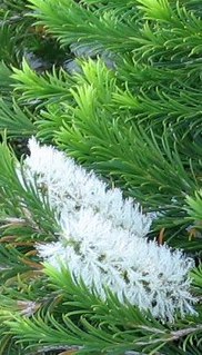
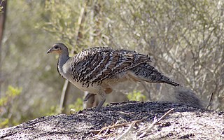
These parks (sic) are dominated by relatively undisturbed mallee forest, and woodland associations with a Melaleuca shrub understorey. They provide important habitat for Malleefowl populations and contain significant species including Gilbert’s Whistler, Bentham’s Goodenia and the Six-nerve Spine-bush which are listed as rare under the National Parks and Wildlife Act.

Mallee (habit) growth habit of certain eucalypt species

Mallee is the growth habit of certain eucalypt species that grow with multiple stems springing from an underground lignotuber, usually to a height of no more than 10 m (33 ft). It is most common in plants of the genus Eucalyptus, many of which naturally grow in a mallee habit, and some of which grow as single-stemmed trees initially, but recover in mallee form if burnt to the ground by bushfire. It also occurs in the closely related genera Corymbia and Angophora. The word "mallee" may also be used as a noun in reference to species or individual plants with a mallee habit.

<i>Melaleuca</i> genus of plants

Melaleuca is a genus of nearly 300 species of plants in the myrtle family, Myrtaceae, commonly known as paperbarks, honey-myrtles or tea-trees. They range in size from small shrubs that rarely grow to more than 1 m high, to trees up to 35 m. Their flowers generally occur in groups, forming a “head” or “spike” resembling a brush used for cleaning bottles, containing up to 80 individual flowers. They are superficially like Banksia species, which also have their flowers in a spike, but the structures of individual flowers in the two genera are very different.

Malleefowl species of bird

The malleefowl is a stocky ground-dwelling Australian bird about the size of a domestic chicken. It is notable for the large nesting mounds constructed by the males and lack of parental care after the chicks hatch. It is the only living representative of the genus Leipoa, though the extinct giant malleefowl was a close relative.

The conservation park is classified as an IUCN Category IA protected area. [1]

International Union for Conservation of Nature international organisation

The International Union for Conservation of Nature is an international organization working in the field of nature conservation and sustainable use of natural resources. It is involved in data gathering and analysis, research, field projects, advocacy, and education. IUCN's mission is to "influence, encourage and assist societies throughout the world to conserve nature and to ensure that any use of natural resources is equitable and ecologically sustainable".

See also

Related Research Articles

Franklin Harbor Conservation Park Protected area in South Australia

Franklin Harbor Conservation Park is a protected area in the Australian state of South Australia located on the east coast of Eyre Peninsula in the gazetted locality of Cowell about 5 kilometres south of the town centre in Cowell.

Sleaford Mere Conservation Park Protected area in South Australia

Sleaford Mere Conservation Park, formerly the Sleaford Mere National Park, is a protected area in the Australian state of South Australia located in the locality of Sleaford on the Jussieu Peninsula at the south eastern tip of Eyre Peninsula about 15 kilometres (9.3 mi) south west of Port Lincoln.

Lincoln Conservation Park Protected area in South Australia

Lincoln Conservation Park is a protected area in the Australian state of South Australia located in the Eyre Peninsula in the gazetted locality of Tulka on land in the Section 490 in the cadastral unit of Hundred of Lincoln about 15 kilometres south west of Port Lincoln.

Shannon Conservation Park Protected area in South Australia

Shannon Conservation Park is a protected area in the Australian state of South Australia located on the Eyre Peninsula in the gazetted locality of Karkoo about 95 kilometres (59 mi) north of Port Lincoln and about 45 kilometres (28 mi) south of Lock.

Heggaton Conservation Park Protected area in South Australia

Heggaton Conservation Park is a protected area in the Australian state of South Australia, located on the Eyre Peninsula in the gazetted locality of Mangalo about 28 kilometres (17 mi) south-east of Kimba.

The Plug Range Conservation Park Protected area in South Australia

The Plug Range Conservation Park is a protected area in the Australian state of South Australia located on the Eyre Peninsula in the gazetted locality of Miltalie about 28 kilometres (17 mi) north-west of Cowell.

Yeldulknie Conservation Park Protected area in South Australia

Yeldulknie Conservation Park is a protected area in the Australian state of South Australia located on the Eyre Peninsula in the gazetted locality of Cleve about 10 kilometres (6.2 mi) north-east of the town centre in Cleve.

Middlecamp Hills Conservation Park Protected area in South Australia

Middlecamp Hills Conservation Park is a protected area in the Australian state of South Australia located on the Eyre Peninsula in the gazetted locality of Cowell about 15 kilometres (9.3 mi) west of the town centre in Cowell.

Carappee Hill Conservation Park Protected area in South Australia

Carappee Hill Conservation Park is a protected area in the Australian state of South Australia located on the Eyre Peninsula in the gazetted locality of Darke Peak about 8 kilometres (5.0 mi) north-east of the town centre in Darke Peak.

Rudall Conservation Park Protected area in South Australia

Rudall Conservation Park is a protected area in the Australian state of South Australia located on the Eyre Peninsula in the gazetted locality of Rudall about 18 kilometres (11 mi) west of the town centre in Cleve.

Darke Range Conservation Park Protected area in South Australia

Darke Range Conservation Park is a protected area in the Australian state of South Australia located on the Eyre Peninsula in the gazetted locality of Darke Peak about 2 kilometres (1.2 mi) west of the town centre in Darke Peak.

Caralue Bluff Conservation Park Protected area in South Australia

Caralue Bluff Conservation Park is a protected area in the Australian state of South Australia located on the Eyre Peninsula in the gazetted locality of Caralue about 24 kilometres (15 mi) south-west of the town centre in Kimba.

Kulliparu Conservation Park Protected area in South Australia

Kulliparu Conservation Park is a protected area in the Australian state of South Australia located on the Eyre Peninsula in the gazetted localities of Colley, Karcultaby, Mount Cooper and Mount Damper about 59 kilometres (37 mi) west of the town centre in Kyancutta.

Cocata Conservation Park Protected area in South Australia

Cocata Conservation Park is a protected area in the Australian state of South Australia located on the Eyre Peninsula in the gazetted localities of Cocata and Warramboo about 26 kilometres (16 mi) south-west of the town centre in Kyancutta.

Wanilla Land Settlement Conservation Park Protected area in South Australia

Wanilla Land Settlement Conservation Park is a protected area located in the Australian state of South Australia on the Eyre Peninsula in the gazetted locality of Wanilla on the southern side of the Wanilla town centre.

Tucknott Scrub Conservation Park Protected area in South Australia

Tucknott Scrub Conservation Park is a protected area located in the Australian state of South Australia on the Eyre Peninsula in the gazetted locality of Whites Flat about 12 kilometres north-east of the town centre in Wanilla and about 30 kilometres north of the municipal seat of Port Lincoln.

Murrunatta Conservation Park Protected area in South Australia

Murrunatta Conservation Park is a protected area in the Australian state of South Australia located on the Eyre Peninsula in the gazetted localities of Wangary and Wanilla about 8 kilometres west of the town centre in Wanilla and about 30 kilometres north-west of municipal seat of Port Lincoln.

Corrobinnie Hill Conservation Park Protected area in South Australia

Corrobinnie Hill Conservation Park is a protected area in the Australian state of South Australia located on the Eyre Peninsula in the gazetted locality of Pinkawillinie about 24 kilometres (15 mi) west of the town centre in Kyancutta.

Kathai Conservation Park Protected area in South Australia

Kathai Conservation Park is a protected area in the Australian state of South Australia located on the Eyre Peninsula in the gazetted locality of Duck Ponds about 5 kilometres south-west of Port Lincoln.

Aberdour Conservation Park Protected area in South Australia

Aberdour Conservation Park is a protected area in the Australian state of South Australia located in the state's south-east in the locality of Willalooka about 226 kilometres (140 mi) south-east of the state capital of Adelaide and about 35 kilometres (22 mi) south of the town of Keith.

References

  1. 1 2 "Terrestrial Protected Areas of South Australia (refer 'DETAIL' tab )". CAPAD 2016. Australian Government, Department of the Environment (DoE). 2016. Retrieved 21 February 2018.
  2. 1 2 "Search result(s) for Sheoak Hill Conservation Park (Record No. SA0061359) with the following layers being selected - "Parcel labels", "Suburbs and Localities", "Hundreds", "Place names (gazetteer)" and "Road labels"". Property Location Browser. Government of South Australia. Retrieved 3 January 2017.
  3. 1 2 "Protected Areas Information System - reserve list (as of 11 July 2016)" (PDF). Department of Environment Water and Natural Resources. 11 July 2016. Retrieved 14 July 2016.
  4. 1 2 3 "Eastern Eyre Peninsula Parks Management Plan" (PDF). Department of Environment, Water and Natural Resources. 2014. pp. 3, 4, 8 & 10. Retrieved 1 January 2017.
  5. "NATIONAL PARKS AND WILDLIFE ACT, 1972-1978: SHEOAK HILL CONSERVATION PARK CONSTITUTED" (PDF). The South Australian Government Gazette. Government of South Australia: 2094. 30 November 1978. Retrieved 3 January 2017.
  6. "CROWN LANDS ACT, 1929: SECTION 5, The Twenty Fifth Schedule" (PDF). The South Australian Government Gazette. Government of South Australia: 2438–2440. 11 November 1993. Retrieved 23 December 2016.
  7. "National Parks and Wildlife (Sheoak Hill Conservation Park) Proclamation 2012" (PDF). The South Australian Government Gazette. Government of South Australia: 4364. 6 September 2012. Retrieved 3 January 2017.