
Protected areas of South Australia consists of protected areas located within South Australia and its immediate onshore waters and which are managed by South Australian Government agencies. As of March 2018, South Australia contains 359 separate protected areas declared under the National Parks and Wildlife Act 1972, the Crown Land Management Act 2009 and the Wilderness Protection Act 1992 which have a total land area of 211,387.48 km2 (81,617.16 sq mi) or 21.5% of the state's area.
Belair National Park is a protected area in Belair, South Australia, 13 kilometres south of Adelaide city centre; it covers an area of 835 hectares. It was proclaimed in 1891 and was the first national park in South Australia, second in Australia and the tenth in the world. The national park lies within the Adelaide Hills and Mitcham council area, and forms part of a chain of protected areas located along the Adelaide Hills Face Zone. The national park is administered by the Department of Environment, Water and Natural Resources.

Murray River National Park is a protected area in South Australia located between 180 kilometres (110 mi) and 240 km (150 mi) north east of the Adelaide city centre. The national park was proclaimed in 1991 "to conserve a significant proportion of South Australia’s floodplain environments which are not represented widely in other reserve systems." The national park consists of three sections adjoining the Murray River and extending from near Loxton in the south west to near Renmark in the north-east. The first which is known as the ‘Katarapko’ section is located on the north side of the river between Loxton in the south and Berri in the north. The second section which is known as the ‘Lyrup Flats’ section is located on the north side of the river midway between Berri and Loxton. The third section is known as the ‘Bulyong’ section is located on the west side of the river upstream from Renmark. The national park is classified as an IUCN Category VI protected area.
Onkaparinga River Recreation Park is a protected area occupying land in the estuary of the Onkaparinga River in South Australia. The recreation park which was established in 1985 is approximately 32 km (20 mi) from Adelaide city centre. It is the venue for recreational activities such as walking, canoeing, kayaking, recreational fishing and picnics.

Totness Recreation Park is a protected area in the Australian state of South Australia located within the localities of Mount Barker and Totness in the central Mount Lofty Ranges. Covering 41 hectares of land, the park is divided by the South Eastern Freeway and features a large dam. It was declared as a reserve in 1970 and re-designated as a recreation park in 1972. The park has no visitor facilities except for access tracks. It is the only park in the district, managed by the Department of Environment and Water, that is solely designated for recreation.

Black Hill Conservation Park, formerly the Black Hill National Park, is a protected area in the Australian state of South Australia located approximately 10 kilometres (6.2 mi) northeast of the state capital of Adelaide. The conservation park is in a rugged bush environment, with a prominent peak, bounded by steep ridges on the southern slopes.

Brownhill Creek Recreation Park is a protected area located about 8 kilometres south of the Adelaide city centre in City of Mitcham along part of the course of the Brown Hill Creek. The recreation park was proclaimed under the National Parks and Wildlife Act 1972 in 1972 to "provide recreation opportunities for the Adelaide and eastern metropolitan region and to conserve remnant aged river red gums and the riparian zone habitat". The land previously subject to protected area status as a "National Pleasure Resort" since 1915. The recreation park is classified as an IUCN Category III protected area.

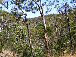
The Kaiserstuhl Conservation Park is a protected area located in the Australian state of South Australia in the suburb of Flaxman Valley about 80 kilometres (50 mi) north-east of the state capital of Adelaide and about 12 kilometres (7.5 mi) south-east of the town of Tanunda.

Horsnell Gully Conservation Park is a protected area in the Australian state of South Australia in the locality of Horsnell Gully located about 9 kilometres (5.6 mi) east of the state capital of Adelaide and about 32 kilometres (20 mi) southwest of Norton Summit.

The Sturt Gorge Recreation Park is a protected area in the Australian state of South Australia located in the suburbs of Bellevue Heights, Craigburn Farm and Flagstaff Hill within the Adelaide metropolitan area about 13 kilometres (8.1 mi) south of the Adelaide central business district.

Para Wirra Conservation Park is a 1,417-hectare (3,500-acre) protected area located in the foothills of the Mount Lofty Ranges in the northern end of the Adelaide metropolitan area in South Australia. The conservation park is part of a larger, 2,573-hectare (6,360-acre) block of contiguous native vegetation, the remainder of which is owned by PIRSA Forestry, SA Water and private landholders.

Granite Island Recreation Park is a protected area including all of Granite Island which is about 0.6 kilometres south-east of Victor Harbor in South Australia and about 120 kilometres south of Adelaide. It is reported as being 'the most visited park in South Australia'. It was proclaimed in 1999 under the National Parks and Wildlife Act 1972 and is categorised as an IUCN Category IV protected area.
Loch Luna Reserve is a protected area covering the floodplain on the north side of the River Murray in South Australia between the towns of Kingston-on-Murray in the west and Cobdogla in the east. It is located about 180 kilometres east north-east of the Adelaide city centre. It was proclaimed on 7 November 1985 with exception to a parcel of land known as Sugarloaf Hill within the boundaries of the game reserve which has been excluded from protection for the purpose of mining activity. The Moorook Game Reserve immediately adjoins the game reserve's southern boundary. It and the Moorook Game Reserve are reported as providing "significant wildlife habitat and are popular recreation sites, particularly for river-based activities and camping." The game reserve is classified as an IUCN Category VI protected area. In 1989, it was listed on the now-defunct Register of the National Estate.
Blackwood Forest Recreation Park is a protected area located about 12 kilometres south of the Adelaide city centre in the suburb of Hawthorndene. The recreation park was proclaimed under the National Parks and Wildlife Act 1972 in 2001 to retain land purchased in 1908 by the Government of South Australia for use as open space for recreational purposes. The recreation park is classified as an IUCN Category III protected area.
O’Halloran Hill Recreation Park is a protected area located about 16 kilometres south of the Adelaide city centre in the suburbs of Seaview Downs and O’Halloran Hill. The recreation park was proclaimed under the National Parks and Wildlife Act 1972 in 1989 for "recreation and nature conservation purposes" in respect to parcels of land acquired by the Government of South Australia starting in the 1970s for three purposes - creation of "an open space buffer", provision of "both visual amenity and recreational opportunities for the rapidly growing southern suburbs" and the creation of "a second ring of parklands around Adelaide that would cater for outdoor pursuits, as well as protecting the Hills Face Zone from development". The recreation park is classified as an IUCN Category III protected area.
Angove Conservation Park is a protected area located about 16 kilometres north-east of the Adelaide city centre within the local government area of the City of Tea Tree Gully. The conservation park was proclaimed under the National Parks and Wildlife Act 1972 in 1994 in order to protect a parcel of undeveloped land which contained remnant native vegetation. The conservation park is classified as an IUCN Category III protected area.
Ferguson Conservation Park, formerly Ferguson National Pleasure Resort and Ferguson Recreation Park, is a protected area in the Australian state of South Australia located within the Adelaide metropolitan area in the suburb of Stonyfell, about 6.5 kilometres east of the Adelaide city centre.
Greenhill Creek Recreation Park is a protected area located in the Australian state of South Australia about 7 kilometres east of the Adelaide city centre in the suburb of Greenhill.
Mylor Conservation Park is a protected area located in the Australian state of South Australia in the suburb of Mylor in the Adelaide Hills state government region about 19 kilometres (12 mi) south-east of the state capital of Adelaide and about 1 kilometre (0.62 mi) north-east of the town of Mylor.
