Nuyts Reef Conservation Park

Last updated

Nuyts Reef Conservation Park
South Australia
Australia South Australia location map.svg
Red pog.svg
Nuyts Reef Conservation Park
Nearest town or city Fowlers Bay [2]
Coordinates 32°6′43″S132°9′6″E / 32.11194°S 132.15167°E / -32.11194; 132.15167 Coordinates: 32°6′43″S132°9′6″E / 32.11194°S 132.15167°E / -32.11194; 132.15167
Established16 March 1967 [3]
Area47 ha (120 acres) [4]
Managing authorities Department for Environment and Water
See also Protected areas of South Australia

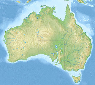
Nuyts Reef Conservation Park is a protected area in the Australian state of South Australia associated with Nuyts Reef which is located off the state's west coast in the Great Australian Bight about 29 kilometres (18 miles) west south-west of Fowlers Bay. [2] [5]

Protected area location which receives protection because of its recognised natural, ecological or cultural landscape values

Protected areas or conservation areas are locations which receive protection because of their recognized natural, ecological or cultural values. There are several kinds of protected areas, which vary by level of protection depending on the enabling laws of each country or the regulations of the international organizations involved.

South Australia State of Australia

South Australia is a state in the southern central part of Australia. It covers some of the most arid parts of the country. With a total land area of 983,482 square kilometres (379,725 sq mi), it is the fourth-largest of Australia's states and territories by area, and fifth largest by population. It has a total of 1.7 million people, and its population is the second most highly centralised in Australia, after Western Australia, with more than 77 percent of South Australians living in the capital, Adelaide, or its environs. Other population centres in the state are relatively small; Mount Gambier, the second largest centre, has a population of 28,684.

Great Australian Bight Oceanic bight off the central and western portions of the southern coastline of mainland Australia

The Great Australian Bight is a large oceanic bight, or open bay, off the central and western portions of the southern coastline of mainland Australia.

The land forming the conservation park was declared as Fauna Conservation Reserve on 16 March 1967 [3] This was reconstituted as Nuyts Reef Conservation Park on 27 April 1972 under the National Parks and Wildlife Act 1972 to "conserve Australian sea lion breeding habitat." [6] [5] On 19 December 1991, additional land was added to the conservation park to extend protection over land located between high tide and low tide. [2] [7] As of 2018, it covered an area of 47 hectares (120 acres). [4]

Australian sea lion species of mammal

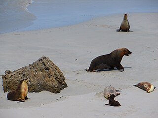
The Australian sea lion also known as the Australian sea-lion or Australian sealion, is a species of sea lion that is the only endemic pinniped in Australia. It is currently monotypic in the genus Neophoca, with the extinct Pleistocene New Zealand sea lion Neophoca palatina the only known congener. These sea lions are sparsely distributed through Houtman Arbrolhos Islands in Western Australia and The Pages Islands in Southern Australia. With a population estimated at around 14,730 animals, the Wildlife Conservation Act of Western Australia (1950) has listed them as “in need of special protection”. Their Conservation status is listed as endangered. These pinnipeds are specifically known for their abnormal breeding cycles, which are varied between 5 months breeding cycle and a 17-18 month aseasonal breeding cycle, compared to other pinnipeds which fit into a 12-month reproductive cycle. Females are either silver or fawn with a cream underbelly and males are dark chocolate brown with a yellow mane and are bigger than the females.

In 1980, the conservation park was described as follows: [8]

A group of five small reefs supporting an Australian sea lion colony and providing breeding habitat for seabirds... Five small granite reefs and rocks, some of which are swept by storm waves. The Reefs are without vegetative cover... Isolation and the absence of introduced species has ensured habitat preservation.

The conservation park including its marine zone is classified as an International Union for Conservation of Nature (IUCN) Category Ia protected area. [9] In 1980, it was listed on the now-defunct Register of the National Estate. [8]

International Union for Conservation of Nature international organisation

The International Union for Conservation of Nature is an international organization working in the field of nature conservation and sustainable use of natural resources. It is involved in data gathering and analysis, research, field projects, advocacy, and education. IUCN's mission is to "influence, encourage and assist societies throughout the world to conserve nature and to ensure that any use of natural resources is equitable and ecologically sustainable".

The Register of the National Estate was a heritage register that listed natural and cultural heritage places in Australia that was closed in 2007. It has been replaced by the Australian National Heritage List and the Commonwealth Heritage List and various state and territory heritage registers.

Related Research Articles

Nuyts Archipelago Conservation Park Protected area in South Australia

Nuyts Archipelago Conservation Park is a protected area in the Australian state of South Australia located on Eyre Island and St Peter Island in the Nuyts Archipelago located off the west coast of Eyre Peninsula about 10 kilometres south and 25 kilometres south-east respectively of Ceduna.

Isles of St Francis Conservation Park Protected area in South Australia

.

Sir Joseph Banks Group Conservation Park Protected area in South Australia

Sir Joseph Banks Group Conservation Park is a protected area in the Australian state of South Australia located on the Sir Joseph Banks Group in Spencer Gulf about 25 kilometres (16 mi) east-northeast of Port Lincoln. The conservation park of which specific islands had been previously declared as Flora and Fauna Reserves under statutes in force prior to 1972, was proclaimed in 1972 under the National Parks and Wildlife Act 1972. It was declared ‘primarily for the conservation of Cape Barren geese, and to protect marine mammal habitat’. As of 1996, the conservation park did not include Spilsby island which is privately owned and ‘lighthouse reserves’ on other islands while the following islands have been added post-declaration - Reevesby Island which was added in 1974 and Dangerous Reef which was added in 1989. The conservation park was subsequently extended to include the waters within 2 nautical miles (4 km) of the shoreline of all islands in the group and Dangerous Reef via a declaration under the National Parks and Wildlife Act 1972 for the purpose of regulating and managing great white shark berleying activities. The conservation park is classified as an IUCN Category Ia protected area.

The Pages Conservation Park Protected area in South Australia

The Pages Conservation Park is a protected area in the Australian state of South Australia which is associated with the island group known as The Pages located in Backstairs Passage about 25 kilometres south-east of Cape Jervis and about 98 kilometres south south-west of the state capital of Adelaide.

Pelican Lagoon Conservation Park Protected area in South Australia

Pelican Lagoon Conservation Park is a protected area located in the Australian state of South Australia on the Dudley Peninsula on Kangaroo Island. It was dedicated in 1967 for the protection of wildlife habitat.

Neptune Islands Conservation Park Protected area in South Australia

Neptune Islands Conservation Park is a protected area occupying most of the Neptune Islands in South Australia about 55 km (34 mi) south-south east of Port Lincoln. It was established in 1967 principally to protect a New Zealand fur seal breeding colony. The conservation park was subsequently expanded to include the adjoining waters in order to control and manage berleying activities used to attract great white sharks. As of 2002, the conservation park is the only place in Australia where shark cage diving to view great white sharks is legally permitted.

Nuyts Archipelago Wilderness Protection Area Protected area in South Australia

Nuyts Archipelago Wilderness Protection Area is a protected area in the Australian state of South Australia located in the Nuyts Archipelago off the west coast of Eyre Peninsula within 10 kilometres to 75 kilometres south-west of Ceduna.

Port Gawler Conservation Park Protected area in South Australia

Port Gawler Conservation Park was a protected area in the Australian state of South Australian located at the east side of Gulf St Vincent on the west side of the locality of Port Gawler. The conservation park covered an area of intertidal mangroves immediately south of Port Gawler beach.

Olive Island Conservation Park Protected area in South Australia

Olive Island Conservation Park is a protected area in the Australian state of South Australia associated with Olive Island off the west coast of Eyre Peninsula and which is located about 25 kilometres west-northwest of the town of Streaky Bay.

Lipson Island Conservation Park Protected area in South Australia

Lipson Island Conservation Park is a protected area in the Australian state of South Australia associated with Lipson Island in Spencer Gulf about 12 kilometres north northeast of Lipson.

Tumby Island Conservation Park Protected area in South Australia

Tumby Island Conservation Park is a protected area in the Australian state of South Australia associated with Tumby Island in Spencer Gulf and located about 5 kilometres southeast of the town of Tumby Bay.

Sleaford Mere Conservation Park Protected area in South Australia

Sleaford Mere Conservation Park, formerly the Sleaford Mere National Park, is a protected area in the Australian state of South Australia located in the locality of Sleaford on the Jussieu Peninsula at the south eastern tip of Eyre Peninsula about 15 kilometres (9.3 mi) south west of Port Lincoln.

Pigface Island Conservation Park Protected area in South Australia

Pigface Island Conservation Park is a protected area in the Australian state of South Australia associated with Pigface Island located in Streaky Bay on the west coast of Eyre Peninsula about 13 kilometres north north-east west of the town of Streaky Bay.

Mount Dutton Bay Conservation Park Protected area in South Australia

Mount Dutton Bay Conservation Park is a protected area in the Australian state of South Australia located on the west coast of Eyre Peninsula on islands located on waters in the sector between the north west to the east of the town of Coffin Bay.

Wittelbee Conservation Park Protected area in South Australia

Wittelbee Conservation Park, formerly the Wittelbee National Park, is a protected area in the Australian state of South Australia located on the west coast of Eyre Peninsula in adjoining the headland of Wittelbee Point about 10 kilometres south east of the town of Ceduna.

Beachport Conservation Park Protected area in South Australia

Beachport Conservation Park, formerly the Beachport National Park, is a protected area located in the Limestone Coast of South Australia about 80 kilometres north-west of Mount Gambier and immediately north of the township of Beachport.

Carribie Conservation Park Protected area in South Australia

Carribie Conservation Park is a protected area located in the Yorke Peninsula of South Australia about 32 kilometres west of Warooka in the locality of Corny Point.

Murat Marine Park Protected area in Australia

Murat Marine Park is a marine protected area located in the Great Australian Bight south of South Australia in waters within the Australian Exclusive economic zone to the west of the island group known as the Nuyts Archipelago and ranging in depth from 15 metres to 70 metres.

Karte Conservation Park Protected area in South Australia

Karte Conservation Park is a protected area located in the Australian state of South Australia in the localities of Karte and Parilla about 193 kilometres (120 mi) east of the state capital of Adelaide and about 26 kilometres (16 mi) north-west of the town of Pinnaroo.

Spring Mount Conservation Park Protected area in South Australia

Spring Mount Conservation Park, formerly the Spring Mount Wild-Life Reserve, is a protected area in the Australian state of South Australia located in the localities of Hindmarsh Valley and Inman Valley about 57 kilometres (35 mi) south of the state capital of Adelaide.

References

  1. "Terrestrial Protected Areas of South Australia (refer 'DETAIL' tab )". CAPAD 2016. Australian Government, Department of the Environment (DoE). 2016. Retrieved 21 February 2018.
  2. 1 2 3 "Search results for "Nuyts Reef Conservation Park" with the following datasets selected – 'NPW and Conservation Properties', 'State Marine Park Network Zoning', 'Suburbs and Localities', 'Hundreds' and 'Gazetteer'". Location SA Map Viewer. Government of South Australian. Retrieved 3 March 2019.
  3. 1 2 Shard, A.J. (16 March 1967). "CROWN LANDS ACT, 1929-1966: FAUNA CONSERVATION RESERVES DEDICATED" (PDF). THE SOUTH AUSTRALIAN GOVERNMENT GAZETTE. Government of South Australia. pp. 961–962. Retrieved 26 January 2019.
  4. 1 2 "Protected Areas Information System - reserve list (as of 8 March 2019)" (PDF). Department of Environment Water and Natural Resources. Retrieved 3 March 2019.
  5. 1 2 Anon (2006). Island Parks of Western Eyre Peninsula Management Plan (PDF). Adelaide: Department for Environment and Heritage, South Australia. p. 1. ISBN   1-921238-18-6.
  6. "No. 56 of 1972 (National Parks and Wildlife Act, 1972)". The South Australian Government Gazette. Government of South Australia: 660 & 703. 27 April 1972. Retrieved 3 March 2019.
  7. Blevins, F.T. (19 December 1991). "NATIONAL PARKS AND WILDLIFE ACT 1972 SECTIONS 29 (3) AND 30 (2): VARIOUS CONSERVATION PARKS— ALTERATION OF BOUNDARIES" (PDF). The South Australian Government Gazette. Government of South Australia. p. 1907. Retrieved 3 March 2019.
  8. 1 2 "Nuyts Reef Conservation Park, Cape Nuyts via Penong, SA, Australia - listing on the now-defunct Register of the National Estate (Place ID 6754)". Australian Heritage Database . Department of the Environment. 21 October 1980. Retrieved 3 March 2019.
  9. "Marine Protected Areas in coastal waters of South Australia". CAPAD 2016. Australian government. 2016. Retrieved 9 January 2018.