Flinders Chase National Park

Last updated

Flinders Chase National Park
South Australia
Remarkable Rocks 02.jpg
Remarkable Rocks, in the southern part of the park
Australia South Australia relief location map.png
Red pog.svg
Flinders Chase National Park
Nearest town or city Kingscote
Coordinates 35°58′38″S136°40′22″E / 35.97722°S 136.67278°E / -35.97722; 136.67278
Established1919
1972 (national park) [2] [3]
Area326.61 km2 (126.1 sq mi) [1]
Managing authorities Department for Environment and Water
Website Flinders Chase National Park
See also Protected areas of South Australia

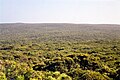
Flinders Chase National Park (formerly Flinders Chase) is a protected area in the Australian state of South Australia located at the west end of Kangaroo Island about 177 kilometres (110 miles) west-south west of the state capital of Adelaide and 110 kilometres (68 miles) west of the municipal seat of Kingscote. It is a sanctuary for endangered species and home to a few geological phenomena. It was the second national park to be declared in South Australia. [4]

Contents

Flinders Chase National Park consists of three sections - an area of coastal landscapes around Cape du Couedic in the south west corner of the island, the Gosse Lands in the centre of the west end of the island and the former Cape Borda Lightstation reserve in the north west corner of the island.

Description

Location

Flinders Chase National Park is located at the north-western end of Kangaroo Island in South Australia approximately 110 kilometres (68 miles) west of Kingscote. [5] It is located within the gazetted localities of Flinders Chase, Gosse and Karatta. [6] [7] [8]

Extent

As of 1993, the national park consists of three separate parcels of land: [5] [9]

Protected area designation

The national park is classified as an IUCN category II protected area. [1]

History

Flinders Chase National Park
Key:-
1
Du Mole River outlet
2
Rocky River ranger station
3
Cape Borda
4
Cape Du Couedic

Following a deputation of scientists in 1906, [10] the premier, Tom Price, agreed to set aside the Cape Borda lighthouse reserve of 61 square miles as a nature reserve. [11] and in 1909 the South Australian government converted another 79 square miles of what had been pastoral reserve to a nature reserve, [lower-alpha 1] under the control of the Fauna and Flora Board. The board had asked for 300 square miles but the additional properties needed had already been leased, and the lessees, who had yet to make any improvements, [13] demanded £28,000 as compensation for losing what they had been getting for £28 per year [14] Professor Stirling urged that when those leases expired they be turned over to the Board. [14]

The reserve was named Flinders Chase at the suggestion of Samuel Dixon [15] (died 1927). [16] Apart from its intended use as a habitat for koalas and other mammals, it was considered a likely refuge for the lyre bird, "pheasant" (perhaps the malleefowl, [Leipoa ocellata]) and "bush turkey" (perhaps Australian brushturkey, [Alectura lathami]), all threatened on the mainland due to depredations by foxes. [15] The Rocky River was touted as a platypus reserve.

Parts of the national park first acquired protected area status as a 'flora and fauna reserve' declared on 16 October 1919 under the Fauna and Flora Reserve Act 1919, an act whose specific purpose was: [2]

…to establish a Reserve on Kangaroo Island for the Protection, Preservation, and Propagation of Australasian Fauna and Flora, and to provide for the Control of such Reserve, and for other purposes.

No funds were made available for fencing or provision of a ranger however, and the laws regarding burning, shooting, poisoning and taking of protected species were unenforceable and broken with impunity. [17] In 1922 the government brought the Chase's total area close to 200 square miles (520 km2) [18] by the addition of the Rocky River freehold and leases south of Rocky River to the landing reserve by the Cape du Couedic lighthouse. The Chase's eastern boundary was now a straight line running south from the De Mole River mouth to the island's south coast. [19] It also gave the board a couple of cottages for the use of a ranger and visitors. [19]

It was constituted as a national park upon the proclamation of the National Parks and Wildlife Act 1972 on 27 April 1972 which repealed five items of existing legislation including the Fauna and Flora Reserve Act 1919. [3] At proclamation in 1972, it consisted of the following land in the following cadastral units as well as the entirety of the Casuarina Islets - section 11 in the Hundred of Borda, section 64 in the Hundred of Gosse, section 17 in the Hundred of McDonald and section 66 in "South out of Hundreds". [20]

On 15 October 1993, land in section 11 of the Hundred of Borda, section 64 of Hundred of Gosse and Allotments 50 and 52 in DP 38340 and with an area of 416.63 square kilometres (160.86 sq mi) was removed from the national park and constituted under the Wilderness Protection Act 1992 as the Ravine des Casoars Wilderness Protection Area. [1] [21]

Sanctuary

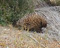
Since creation in November 1919, it has become a sanctuary for endangered species, some of them introduced from the mainland in the 1920s and 1930s. During the 1940s, 23 additional species were introduced, including koalas (1923) and platypus (1928). Most of these species can still be observed today. Kangaroos, goannas and echidnas [22] are commonly seen in the national park.[ citation needed ]

Little penguins

Little penguins have been recorded in Flinders Chase in the 1920s, [23] 1930s, [24] [25] 1940s, [26] and 1950s. [27] It is believed that these colonies have since gone extinct, partly due to the increase of long-nosed fur seal populations after the end of commercial sealing. In 1886, little penguins were seen at Admiral's Arch. [28]

Geological monuments

The national park contains two geological features that have been listed as geological monuments by the Geological Society of Australia - Cape du Couedic and Remarkable Rocks. [29]

Remarkable Rocks are naturally sculptured formations precariously balanced atop a granite outcrop. They remind visitors of the sculptures of Henry Moore. [30]

Fire

Lightning strikes on Thursday 6 December 2007 caused approximately 60,000 hectares (150,000 acres) of land in both the national park and the adjoining Ravine des Casoars Wilderness Protection Area to be burnt, before being brought under control ten days later. [31] The national park was again damaged during the 2019–20 Australian bushfire season, [32] with the Visitor Centre completely destroyed.

See also

Notes and references

  1. These figures are inexact: figures of 60 square miles for the first and 86 for the second have been reported. [12]
  1. 1 2 3 4 "Terrestrial Protected Areas of South Australia (refer 'DETAIL' tab )". CAPAD 2016. Australian Government, Department of the Environment (DoE). 2016. Retrieved 21 February 2018.
  2. 1 2 "Chief Secretary's Office, Adelaide, October 16th, 1919. (i.e. acts assented to by the Governor)" (PDF). The South Australian Government Gazette. Government of South Australia: 949. 19 October 1919. Retrieved 21 May 2017.
  3. 1 2 "Chief Secretary's Department, Adelaide, 27th April, 1972, list of act assented to by the" (PDF). The South Australian Government Gazette. Government of South Australia: 1633. 27 April 1972. Retrieved 21 May 2017.
  4. flightcentre.com.au [ failed verification ]
  5. 1 2 "Flinders Chase National Park, Kelly Hill Conservation Park, Ravine des Casoars Wilderness Protection Area and Cape Bouguer Wilderness Protection Area Management Plans" (PDF). Department for Environment, Heritage and Aboriginal Affairs. 1999. p. 5. Retrieved 1 May 2014.
  6. "Search result for "Flinders Chase (Locality Bounded)" (Record no SA0058416 ) with the following layers being selected - "Suburbs and Localities"and "Road Labels"". Department of Planning, Transport and Infrastructure. Retrieved 6 March 2016.
  7. "Search result for "Gosse (Locality Bounded)" (Record no SA0027114) with the following layers selected - "Suburbs and Localities" and "Road Labels"". Department of Planning, Transport and Infrastructure. Retrieved 8 March 2016.
  8. "Search result for "Karatta (Locality Bounded)" (Record no SA0034161) with the following layers selected - "Suburbs and Localities" and "Road Labels"". Department of Planning, Transport and Infrastructure. Retrieved 8 March 2016.
  9. "Protected Areas of South Australia September (Map) 2015 Edition" (PDF). Department of Environment, Water and Natural Resources (DEWNR). 30 July 2015. Archived (PDF) from the original on 23 September 2015. Retrieved 15 April 2015.
  10. "Fauna and Flora Protection". The Observer (Adelaide) . Vol. LXIII, no. 3, 384. South Australia. 11 August 1906. p. 26. Retrieved 20 February 2022 via National Library of Australia.
  11. "Home for Australian Fauna". The Daily Herald (Adelaide) . Vol. 2, no. 384. South Australia. 29 May 1911. p. 4. Retrieved 18 February 2022 via National Library of Australia.
  12. "Bird Protection in South Australia". The Advertiser (Adelaide) . Vol. LV, no. 16, 883. South Australia. 25 November 1912. p. 11. Retrieved 18 February 2022 via National Library of Australia.
  13. "A National Reserve". The Southern Cross (South Australia) . Vol. XXIII, no. 1139. South Australia. 16 June 1911. p. 11. Retrieved 18 February 2022 via National Library of Australia.
  14. 1 2 "Fauna and Flora". The Register (Adelaide) . Vol. LXXIII, no. 19, 083. South Australia. 11 January 1908. p. 10. Retrieved 20 February 2022 via National Library of Australia.
  15. 1 2 "Kangaroo Island Reserve". The Advertiser (Adelaide) . Vol. LII, no. 15, 939. South Australia. 17 November 1909. p. 11. Retrieved 17 February 2022 via National Library of Australia. "Chase" is an old English term for a private game reserve.
  16. "Obituary". The Glenelg Guardian . Vol. XIII, no. 747. South Australia. 1 September 1927. p. 2. Retrieved 17 February 2022 via National Library of Australia.
  17. "The Fur Industry". The South Eastern Times . No. 1945. South Australia. 20 October 1925. p. 4. Retrieved 18 February 2022 via National Library of Australia.
  18. Neville Cordes (1972). Portrait of an Island. Islander Newspapers, Kingscote KI.
  19. 1 2 "Fauna and Flora". The News (Adelaide) . Vol. II, no. 142. South Australia. 5 January 1924. p. 3. Retrieved 20 February 2022 via National Library of Australia.
  20. National Parks and Wildlife Act (No 56 of 1972) (SA)
  21. Wiese, B.J. (15 October 1993). "WILDERNESS PROTECTION ACT 1992 SECTION 22(1): CONSTITUTION OF RAVINE DES CASOARS WILDERNESS PROTECTION AREA" (PDF). The South Australian Government Gazette. Government of South Australia. p. 1755. Retrieved 25 January 2019.
  22. Rismiller, Peggy (2005). "Echidna research, Kangaroo island". Pelican Lagoon Research & Wildlife Centre. Archived from the original on 21 February 2015. Retrieved 15 July 2012.
  23. "Cape de Coudie Light. Guarding rocky coast. Lighthouse keeper's life." The Mail, South Australia (1926-01-23). Retrieved 2014-03-13.
  24. Hill, Ernestine "A Southern Eden. Flinders Chase and its family" The Advertiser, South Australia (1936-09-05). Retrieved 2014-03-13.
  25. "Sanctuary - Flinders Chase" The Mail, South Australia (1935-03-30). Retrieved 2014-03-13.
  26. "Preserving our wildlife - Work being done at Flinders Chase" The Advertiser, South Australia (1946-02-13). Retrieved 2014-03-12.
  27. N.Q. Naturalists Club "Current Nature Notes. Flinders Chase, Kangaroo Island." Townsville Daily Bulletin, Queensland, Australia (1953-04-25). Retrieved 2014-03-13.
  28. "Trip across Kangaroo Island" South Australian Register, South Australia (1886-12-07). Retrieved 2014-03-13.
  29. Kangaroo Island Natural Resources Management Board (2008), Here to stay for our children and grandchildren : a natural resources management plan for the Kangaroo Island region 2009 (PDF), vol. 1, Kangaroo Island Natural Resources Management Board (published 2009), pp. 88–89, ISBN   978-1-921595-00-4
  30. Alice Reid (12 July 2009). "Kangaroo Island Will Drive You Wild". The Washington Post . The "Remarkable Rocks," as they are called, are a collection of enormous eroded granite boulders sitting atop a giant dome of lava coughed up about 200 million years ago. Wind and sea spray have since carved the chunks into what look like monumental Henry Moore sculptures perched 200 feet above a crashing sea.
  31. "Flinders Chase Fire Management Plan 2009-2014 (Incorporating Flinders Chase National Park, Ravine des Casoars Wilderness Protection Area, Cape Bouguer Wilderness Protection Area and Kelly Hill Conservation Park)" (PDF). Department for Environment and Heritage, Government of South Australia. September 2009. p. 14. Retrieved 8 January 2020.
  32. "Scorched earth: The bushfire devastation on Kangaroo Island – in pictures". The Guardian. 7 January 2020.

Related Research Articles

<span class="mw-page-title-main">Lincoln National Park</span> Protected area in South Australia

Lincoln National Park is a protected area in the Australian state of South Australia located about 249 kilometres (155 mi) west of the state capital of Adelaide and about 9.5 kilometres (5.9 mi) south of the municipal seat of Port Lincoln. It consists of a mainland area on the Jussieu Peninsula on the south eastern tip of Eyre Peninsula and a number of nearby islands. The national park contains significant sites of natural, indigenous and early European heritage.

<span class="mw-page-title-main">Kangaroo Island</span> Island in South Australia

Kangaroo Island, also known as Karta Pintingga, is Australia's third-largest island, after Tasmania and Melville Island. It lies in the state of South Australia, 112 km (70 mi) southwest of Adelaide. Its closest point to the mainland is Snapper Point in Backstairs Passage, which is 13.5 km (8.4 mi) from the Fleurieu Peninsula.

Ravine Des Casoars Wilderness Protection Area is a protected area located on the west end of Kangaroo Island in South Australia about 80 km (50 mi) west of Kingscote. It was established in 1993 on land previously part of the Flinders Chase National Park.

Cape du Couedic is a headland in the Australian state of South Australia located on the southwest tip of Kangaroo Island in the locality of Flinders Chase. It was named after a French naval officer, Charles Louis du Couëdic de Kergoualer, by the Baudin expedition to Australia during January 1803. It is the site for the Cape du Couedic Lighthouse. It is currently located within the Flinders Chase National Park.

<span class="mw-page-title-main">Investigator Strait</span> Body of water in South Australia

Investigator Strait is a body of water in South Australia lying between the Yorke Peninsula, on the Australian mainland, and Kangaroo Island. It was named by Matthew Flinders after his ship, HMS Investigator, on his voyage of 1801–1802. It is bordered by the Gulf St Vincent in the northeast.

<span class="mw-page-title-main">Cape Borda</span> Place in South Australia

Cape Borda is a headland in the Australian state of South Australia located in the gazetted locality of Cape Borda on the north west tip of Kangaroo Island about 70 km (43 mi) west of the municipal seat of Kingscote. It was named after Jean-Charles de Borda (1733–1799), the French mathematician, physicist, naturalist and sailor, by the Baudin expedition to Australia during January 1803. It has been the site of an operating lighthouse since 1858 and is currently located within the Flinders Chase National Park.

<span class="mw-page-title-main">2007 Kangaroo Island bushfires</span>

The 2007 Kangaroo Island bushfires were a series of bushfires caused by lightning strikes on 6 December 2007 on Kangaroo Island, South Australia, resulting in the destruction of 95,000 hectares of national park and wilderness protection area. The fires occurred mainly across the western side of the island near Flinders Chase National Park, Vivonne Bay, D'Estrees Bay, Western River and Riverleas.

<span class="mw-page-title-main">Mount Lofty woodlands</span> Ecoregion in South Australia

The Mount Lofty woodlands, or the Peppermint Box Grassy Woodland of South Australia, is an ecoregion in South Australia, which includes woodlands, shrublands, and grasslands in the Mount Lofty Ranges, Fleurieu Peninsula, and Kangaroo Island.

Western River Wilderness Protection Area, formerly the Western River Conservation Park and the Western River National Park, is a protected area in the Australian state of South Australia located on the north coast of Kangaroo Island about 30 kilometres (19 mi) west of Parndana in the gazetted locality of Western River. Waterfall Creek, with its scenic Billy Goat Waterfall, are within the area.

<span class="mw-page-title-main">Ravine des Casoars</span> Gorge and associated drainage basin in Australia

Ravine des Casoars is a gorge and an associated drainage basin in the Australian state of South Australia located on the west coast of Kangaroo Island about 95 kilometres west of Kingscote.

Cape Bouguer Wilderness Protection Area is a protected area located on the south coast of Kangaroo Island in South Australia about 84 kilometres south-west of Kingscote. The wilderness protection area was proclaimed in October 1993 under the Wilderness Protection Act 1992 in order to ‘protect and preserve the outstandingly high wilderness qualities of the area.’ It was created on land excised from the Kelly Hill Conservation Park. It is classified as an IUCN Category Ib protected area.

The Rocky River is a stream in the Australian state of South Australia located on the west end of Kangaroo Island in the locality of Flinders Chase.

Maupertuis Bay is a bay in the Australian state of South Australia located on the south-west coastline of Kangaroo Island.

<span class="mw-page-title-main">Cape Borda, South Australia</span> Suburb of Kangaroo Island Council, South Australia

Cape Borda is a locality in the Australian state of South Australia located on Kangaroo Island about 192 kilometres south-west of the state capital of Adelaide.

Gosse is a locality in the Australian state of South Australia located on Kangaroo Island about 175 kilometres south-west of the state capital of Adelaide city centre.

<span class="mw-page-title-main">Flinders Chase, South Australia</span> Suburb of Kangaroo Island Council, South Australia

Flinders Chase is a locality in the Australian state of South Australia located on the south-western coast of Kangaroo Island overlooking the body of water known in Australia as the Southern Ocean and by international authorities as the Great Australian Bight. It is located about 210 kilometres south-west of the state capital of Adelaide.

De Mole River is a locality in the Australian state of South Australia located on the north coast of Kangaroo Island overlooking Investigator Strait about 175 kilometres south-west of the state capital of Adelaide.

Karatta is a locality in the Australian state of South Australia located on the south coast of Kangaroo Island overlooking the body of water known in Australia as the Southern Ocean and by international authorities as the Great Australian Bight. Karatta is located about 191 kilometres south-west of the state capital of Adelaide.

<span class="mw-page-title-main">County of Carnarvon (South Australia)</span> Cadastral in South Australia

County of Carnarvon is a cadastral unit located in the Australian state of South Australia which covers the full extent of Kangaroo Island. It was proclaimed in 1874 by Governor Musgrave in response to the demand for agriculture land on Kangaroo Island.

<span class="mw-page-title-main">Western River, South Australia</span> Suburb of Kangaroo Island Council, South Australia

Western River is a locality in the Australian state of South Australia located on the north coast of Kangaroo Island overlooking Investigator Strait about 170 kilometres south-west of the state capital of Adelaide and about 64 kilometres west of the municipal seat of Kingscote.