Scorpion Springs Conservation Park South Australia | |
---|---|
Nearest town or city | Pinnaroo [2] |
Coordinates | 35°32′34″S140°53′14″E / 35.54287°S 140.88724°E Coordinates: 35°32′34″S140°53′14″E / 35.54287°S 140.88724°E [1] |
Established | 9 July 1970 [3] |
Abolished | 27 May 2004 [4] |
Area | 303.43 km2 (117.2 sq mi) [5] : ii |
Managing authorities | Department for Environment and Heritage (2004) [5] : i |
See also | Protected areas of South Australia |
Scorpion Springs Conservation Park (formerly Scorpion Well National Park) was a protected area in the Australian state of South Australia located in the state’s south-east in the locality of Pinnaroo at the border with the state of Victoria about 215 kilometres (134 mi) south-east of the state capital of Adelaide and about 16 kilometres (9.9 mi) south of the town of Pinnaroo. [2] [6]
The conservation park consisted of land in the following cadastral units located at the southern end of the locality of Pinnaroo - section 16 in the Hundred of Fisk, sections 9 and 10 in the Hundred of Quirke and section 65 in “South Out of Hundreds”. [2] [5] : 56 The land first received protected area status as the Scorpion Well National Park proclaimed on 9 July 1970 under the National Parks Act 1966. [3] On 27 April 1972, the national park was reconstituted as the Scorpion Springs Conservation Park under the National Parks and Wildlife Act 1972 . [7] The establishment of both it and the Mount Shaugh Conservation Park were planned “concurrently with the development of adjacent areas for farming in the late 1960s” in order “to conserve the mallee heath habitat of the 90 Mile Desert”. [5] : 6
Its name was derived from “Scorpion Soakage” (also known as “Scorpion Spring”) which is a water source used by the Ngarkat Aboriginal people and which was located within the conservation park’s boundaries. [2] [8]
On 27 May 2004, the conservation park and the nearby Mount Rescue and Mount Shaugh Conservation Parks were abolished and their land holdings were added to that of the adjoining Ngarkat Conservation Park. [4] As of February 2004, the conservation park covered an area of 303.43 square kilometres (117.15 sq mi). [5] : ii
In 1980, the conservation park was described as follows: [6]
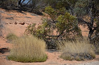
A sand plain with irregular dunes and interdune valleys. The predominant vegetation associations are Eucalyptus incrassata / E. foecunda open scrub, with Melaleuca uncinata callitris verrucose and Xanthorrhoea australis / Banksia ornata / Casuarina pusilla heath. Areas of E baxteri low woodland are found in low lying areas and in the lee of large dunes. Indigenous values are known to exist in this area. As yet these have not been identified, documented or assessed for national estate significance by the Commission…
Scorpion Springs is a wilderness area providing habitat for a great diversity of species, including the threatened red lored whistler and mallee fowl and the Tasmanian pygmy possum. The significance of this park is further enhanced by its continuity with Ngarkat Conservation Park and a large park on the Victorian side of the border. These parks combined, form a large wilderness area of National significance…
This park is in near pristine condition having suffered little grazing and possessing limited vehicular access. Scorpion Springs forms part of the largest block of natural scrub in the settled areas of South Australia.
The conservation park was classified in 2002 as being an IUCN Category Ia protected area. [1] In 1980, it was listed on the now-defunct Register of the National Estate. [6]
Ngarkat Conservation Park is a protected area located in South Australia's south-eastern corner about 200 kilometres south east of the Adelaide city centre.
Peebinga Conservation Park is a 34 km2 protected area lying 40 km north of the town of Pinnaroo in the Murray Mallee region of south-eastern South Australia, about 240 km east of Adelaide and 10 km west of the Victorian border.
Wittelbee Conservation Park, formerly the Wittelbee National Park, is a protected area in the Australian state of South Australia located on the west coast of Eyre Peninsula in adjoining the headland of Wittelbee Point about 10 kilometres south east of the town of Ceduna.
Nene Valley Conservation Park is a protected area in the Australian state of South Australia located in the localities of Blackfellows Caves and Nene Valley in the state's south-east about 35 kilometres south west of the municipal seat of Mount Gambier and about 18 kilometres west north west of Port MacDonnell.
Carribie Conservation Park is a protected area located in the Yorke Peninsula of South Australia about 32 kilometres west of Warooka in the locality of Corny Point.
Ramsay Conservation Park is a protected area in the Australian state of South Australia located in the Yorke Peninsula in the locality of Ramsay about 6.5 kilometres west-northwest of the town of Port Vincent.
Bakara Conservation Park is a protected area of mallee scrub in the Murray Mallee region of South Australia. It is located in the locality of Maggea on the southern side of the Stott Highway.
Ngarkat is a locality in the Australian state of South Australia located in the south-east of the state at the border with the state of Victoria in both the Murray Mallee and the Limestone Coast regions about 227 kilometres south east of the state capital of Adelaide.
Caratoola Recreation Park is a protected area in the Australian state of South Australia located in the locality of Haslam about 0.5 kilometres north of the town of Haslam and about 35 kilometres north of the town of Streaky Bay.
Verran Tanks Conservation Park is a protected area in the Australian state of South Australia, located on the Eyre Peninsula in the gazetted locality of Verran about 105 kilometres (65 mi) north of Port Lincoln and about 55 kilometres (34 mi) south-east of Lock.
Barwell Conservation Park is a protected area in the Australian state of South Australia located on Eyre Peninsula in the gazetted localities of Palkagee and Polda about 140 kilometres (87 mi) north of Port Lincoln and about 15 kilometres (9.3 mi) west of Lock.
Bascombe Well Conservation Park, formerly known as Bascombe Well National Park, is a protected area in the Australian state of South Australia located on Eyre Peninsula in the gazetted localities of Kappawanta and Murdinga about 115 kilometres (71 mi) north of Port Lincoln and about 25 kilometres (16 mi) south-west of Lock.
.
.
The Ngarkat is a recorded title of a tribal group from South Australia. The Ngarkat lands had linked the mallee peoples of Victoria and South Australia to the river peoples of the Murray River Murraylands. Ngarkat language has been loosely grouped with Peramangk language though not by linguists, and the grouping was perhaps partly owed to the co-ownership of lands in both the Ninety Mile Desert and Echunga by John Barton Hack, and partly to the occasional meeting of tribes. The language of the Ngarkat was recorded as being Boraipur by Ryan in recent times though sources were not given, while it may yet be telling that the citing work concerns Mallee peoples to the east. The language may have been midway between that of mallee peoples to the east, and that of peoples to the west recorded by Teichelmann and Schurman. It is known that songlines linked the Coorong to the Mallee regions, hence went through Ngarkat land. It is also known that Ngarkat people did meet regularly with tribes to the east, at sites along the Murray.
Lowan Conservation Park is a protected area located in the Australian state of South Australia in the locality of Bowhill about 99 kilometres (62 mi) east of the state capital of Adelaide and about 9 kilometres (5.6 mi) west of the town of Perponda.
Karte Conservation Park is a protected area located in the Australian state of South Australia in the localities of Karte and Parilla about 193 kilometres (120 mi) east of the state capital of Adelaide and about 26 kilometres (16 mi) north-west of the town of Pinnaroo.
The County of Chandos is one of the 49 cadastral counties of South Australia. It was proclaimed in 1893 and named by Governor Kintore for the Duke of Buckingham and Chandos, Richard Temple-Nugent-Brydges-Chandos-Grenville who was appointed Secretary of State for the Colonies in 1867. It covers a large portion of the southern Mallee region, adjacent to the state border with Victoria in the state's south east.
Pooginook Conservation Park is a protected area located in the Australian state of South Australia in the locality of Pooginook about 166 kilometres (103 mi) north-east of the state capital of Adelaide and about 12 kilometres (7.5 mi) north-east of the town of Waikerie.
Mount Boothby Conservation Park, formerly the Mount Boothby National Park, is a protected area in the Australian state of South Australia located in the locality of Field about 147 kilometres (91 mi) south-east of the state capital of Adelaide and about 14 kilometres (8.7 mi) west of the Culburra town centre on the Dukes Highway.