Deep Creek National Park

Last updated

Deep Creek National Park
Deep Creek & Delamere,  South Australia
Australia South Australia relief location map.png
Red pog.svg
Deep Creek National Park
Nearest town or city Cape Jervis [2]
Coordinates 35°37′40″S138°13′19″E / 35.62778°S 138.22194°E / -35.62778; 138.22194 Coordinates: 35°37′40″S138°13′19″E / 35.62778°S 138.22194°E / -35.62778; 138.22194
Established30 September 1971 [3]
Area44.96 km2 (17.4 sq mi) [4]
Visitation"25,000−30,000" [lower-alpha 1]  (in 1997) [5] :20
Managing authorities Department for Environment and Water
Website Deep Creek National Park
See also Protected areas of South Australia

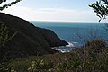
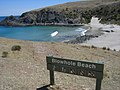
Deep Creek National Park, formerly the Deep Creek Conservation Park, is a protected area in the Australian state of South Australia located on the southern coast of Fleurieu Peninsula in the gazetted localities of Deep Creek and Delamere about 11 kilometres (6.8 miles) east of Cape Jervis. [2] [3]

Contents

History

Formerly a conservation park known as Deep Creek Conservation Park, it was renamed Deep Creek National Park upon being proclaimed a national park on 26 November 2021 [6] [7]

Description

The park is the largest portion of remaining natural vegetation on the Fleurieu Peninsula, and is home to much native wildlife, including western grey kangaroos, short-beaked echidnas and around 100 species of birds. [8]

The park encompasses 18 kilometres (11 miles) of coastline, which include views across Backstairs Passage to Kangaroo Island. The conservation park consists of mainly rolling coastal hills, the gullies of which contain orchids and ferns, while the hilltops have stunted scrub and low windswept trees. Walking trails (including part of the famous Heysen Trail) provide access to most of the conservation park.[ citation needed ]

It is classified as an IUCN class II protected area. [1] In 1980, it was listed on the now-defunct Register of the National Estate. [9]

Camping

The conservation park has five camping areas available with various facilities.[ citation needed ]

See also

Related Research Articles

Heysen Trail Long-distance trail in Australia

The Heysen Trail is a long distance walking trail in South Australia. It runs from Parachilna Gorge, in the Flinders Ranges via the Adelaide Hills to Cape Jervis on the Fleurieu Peninsula and is approximately 1,200 kilometres (750 mi) in length.

Cape Jervis Town in South Australia

Cape Jervis is a town in the Australian state of South Australia located near the western tip of Fleurieu Peninsula on the southern end of the Main South Road approximately 88 kilometres (55 mi) south of the state capital of Adelaide.

<span class="mw-page-title-main">Mount Lofty Ranges</span> Mountain range in Australia

The Mount Lofty Ranges are a range of mountains in the Australian state of South Australia which for a small part of its length borders the east of Adelaide. The part of the range in the vicinity of Adelaide is called the Adelaide Hills and defines the eastern border of the Adelaide Plains.

Cleland National Park Protected area in South Australia

Cleland National Park, formerly Cleland Conservation Park, is a protected area located in the Adelaide Hills, South Australia about 22 kilometres (14 mi) south-east of the Adelaide city centre. It conserves a significant area of natural bushland on the Adelaide Hills face, including Mount Lofty Summit and Waterfall Gully.

Talisker Conservation Park Protected area in South Australia

Talisker Conservation Park is a protected area in the Australian state of South Australia located on the south-western area of the Fleurieu Peninsula near the town of Cape Jervis and adjacent to Deep Creek Conservation Park. The conservation park covers 211 ha including areas of thick scrub, some steep walking tracks and the heritage-listed remains of a nineteenth century silver and lead mine.

Mount Magnificent Conservation Park Protected area in South Australia

Mount Magnificent Conservation Park is a protected area in the Australian state of South Australia located in the Mount Lofty Ranges about 58 kilometres south of the state capital of Adelaide. It is located within the gazetted locality of Mount Magnificent.

Finniss Conservation Park Protected area in South Australia

Finniss Conservation Park is a protected area in the Australian state of South Australia located in the Mount Lofty Ranges about 43 kilometres south of the state capital of Adelaide and about 7 kilometres west of Ashbourne. It is located within the gazetted locality of Mount Magnificent.

Kaiserstuhl Conservation Park Protected area in South Australia

The Kaiserstuhl Conservation Park is a protected area located in the Australian state of South Australia in the suburb of Flaxman Valley about 80 kilometres (50 mi) north-east of the state capital of Adelaide and about 12 kilometres (7.5 mi) south-east of the town of Tanunda.

Horsnell Gully Conservation Park Protected area in South Australia

Horsnell Gully Conservation Park is a protected area in the Australian state of South Australia in the locality of Horsnell Gully located about 9 kilometres (5.6 mi) east of the state capital of Adelaide and about 2.3 kilometres (1.4 mi) southwest of Norton Summit.

Backstairs Passage Body of water

The Backstairs Passage is a strait in South Australia lying between Fleurieu Peninsula on the Australian mainland and Dudley Peninsula on the eastern end of Kangaroo Island. The western edge of the passage is a line from Cape Jervis on Fleurieu Peninsula to Kangaroo Head on Kangaroo Island. The Pages, a group of islets, lie in the eastern entrance to the strait. About 14 km wide at its narrowest, it was formed by the rising sea around 13,000 years ago, at the end of the Pleistocene era, when it submerged the land connecting what is now Kangaroo Island with the Fleurieu Peninsula. Backstairs Passage was named by Matthew Flinders whilst he and his crew on HMS Investigator were exploring and mapping the coastline of South Australia in 1802.

Mount Brown Conservation Park is a protected area in the Flinders Ranges of South Australia. The park has established walking trails, including a section of the Heysen Trail. The park is managed by the Department of Environment, Water and Natural Resources; entry is free. It is located 14 km (8.7 mi) south of Quorn and about 300 km (190 mi) north of the nearest airport at Adelaide.

Newland Head Conservation Park Protected area in South Australia

Newland Head Conservation Park is a protected area located in South Australia within the locality of Waitpinga on the southern coast of the Fleurieu Peninsula 91 km south of the centre of Adelaide, and 7 km southwest of Victor Harbor. Its name is taken from Newland Head that feature prominently at the eastern boundary of the park. The conservation park is classified as an IUCN Category III protected area.

Giles Conservation Park is a protected area in the Australian state of South Australia located approximately 10 km (6.2 mi) east of the state capital of Adelaide. It was declared in 2007 and has an area of 109 ha. Previously, the land was the eastern portion of the Horsnell Gully Conservation Park. It was named after the family of Charles Giles who is reported as being a pioneer in the fields of horticulture and floriculture in South Australia.

Telowie Gorge Conservation Park Protected area in South Australia

Telowie Gorge Conservation Park, formerly Telowie Gorge National Park, was a protected area located in the Australian state of South Australia to the east of the town of Port Germein in the gazetted locality of Telowie. It became part of the Wapma Thura–Southern Flinders Ranges National Park on 25 November 2021.

The Dutchmans Stern Conservation Park Protected area in South Australia

The Dutchmans Stern Conservation Park is a protected area located in South Australia about 5 kilometres north-west of the town of Quorn in the Flinders Ranges. It includes a mountain known as The Dutchmans Stern from which its name is derived.

Kyeema Conservation Park is a protected area located in the Australian state of South Australia in the locality of Kyeema about 38 kilometres (24 mi) south of the state capital of Adelaide and about 12 kilometres (7.5 mi) east of the town of Willunga.

Caroona Creek Conservation Park is a protected area located in the Australian state of South Australia in the localities of Collinsville and Mount Bryan East about 173 kilometres (107 mi) north-east of the state capital of Adelaide and about 19 kilometres (12 mi) east of the town of Hallett.

Mylor Conservation Park is a protected area located in the Australian state of South Australia in the suburb of Mylor in the Adelaide Hills state government region about 19 kilometres (12 mi) south-east of the state capital of Adelaide and about 1 kilometre (0.62 mi) north-east of the town of Mylor.

Hopkins Creek Conservation Park is a protected area located in the Australian state of South Australia in the locality of Emu Downs about 125 kilometres (78 mi) north-east of the state capital of Adelaide and about 21 kilometres (13 mi) south of the town of Burra.

Myponga Conservation Park is a protected area located in the Australian state of South Australia in the locality of Myponga about 59 kilometres (37 mi) south of the state capital of Adelaide and about 5 kilometres (3.1 mi) south-south-west of the town of Myponga.

References

Notes

  1. Visitor numbers shared with Talisker Conservation Park

Citations

  1. 1 2 "Terrestrial Protected Areas of South Australia (refer 'DETAIL' tab )". CAPAD 2016. Australian Government, Department of the Environment (DoE). 2016. Retrieved 21 February 2018.
  2. 1 2 "Search result for "Deep Creek Conservation Park" (Record no SA0019531) with the following layers selected - "Suburbs and Localities" and " Place names (gazetteer)"". Property Location Browser. Government of South Australia. Retrieved 8 August 2016.
  3. 1 2 Shard, A.J. (30 September 1971). "NATIONAL PARKS ACT, 1966: DECLARATION OF NATIONAL PARK" (PDF). The South Australian Government Gazette. Government of South Australia. p. 1226. Retrieved 11 January 2019.
  4. "Protected Areas Information System - reserve list (as of 17 Feb 2014)" (PDF). Department of Environment Water and Natural Resources. p. 5. Retrieved 16 March 2014.
  5. Deep Creek and Talisker Conservation Parks management plan, Fleurieu, South Australia (PDF), Department of Environment and Natural Resources (South Australia), 1997, p. 20, ISBN   978-0-7308-5830-0 , retrieved 25 September 2019
  6. Speirs, David (26 November 2021). "SA now home to Australia's biggest national park". Premier of South Australia . Retrieved 19 December 2021. CC-BY icon.svg Text may have been copied from this source, which is available under a Attribution 3.0 Australia (CC BY 3.0 AU) licence.
  7. Gooch, Declan (26 November 2021). "Australia's biggest national park declared in South Australia's far north". ABC News. Australian Broadcasting Corporation . Retrieved 19 December 2021.
  8. "Deep Creek National Park". National Parks and Wildlife Service South Australia. Retrieved 19 December 2021. CC-BY icon.svg Text may have been copied from this source, which is available under a Attribution 3.0 Australia (CC BY 3.0 AU) licence.
  9. "Deep Creek Conservation Park, Blowhole Creek Rd, Cape Jervis (sic), SA, Australia - listing on the now-defunct Register of the National Estate (Place ID 7782)". Australian Heritage Database . Australian Government. 21 October 1980. Retrieved 27 September 2019.