Kangaroo Island, also known as Karta Pintingga, is Australia's third-largest island, after Tasmania and Melville Island. It lies in the state of South Australia, 112 km (70 mi) southwest of Adelaide. Its closest point to the mainland is Snapper Point in Backstairs Passage, which is 13.5 km (8.4 mi) from the Fleurieu Peninsula.

The Fleurieu Peninsula is a peninsula in the Australian state of South Australia located south of the state capital of Adelaide.

Gulf St Vincent, sometimes referred to as St Vincent Gulf, St Vincent's Gulf or Gulf of St Vincent, is the eastern of two large inlets of water on the southern coast of Australia, in the state of South Australia, the other being the larger Spencer Gulf, from which it is separated by Yorke Peninsula. On its eastern side the gulf is bordered by the Adelaide Plains and the Fleurieu Peninsula. To the south it is defined by a line from Troubridge Point on Yorke Peninsula to Cape Jervis on Fleurieu Peninsula. Its entrances from the southwest are from Investigator Strait, and to the southeast from Backstairs Passage, which separate Kangaroo Island from the mainland. Adelaide, the South Australian capital, lies midway along the gulf's east shore. Other towns located on the gulf, from west to east include Edithburgh, Port Vincent, Ardrossan and Port Wakefield and Normanville.

Cape Jervis is a town in the Australian state of South Australia located near the western tip of Fleurieu Peninsula on the southern end of the Main South Road approximately 88 kilometres (55 mi) south of the state capital of Adelaide.
Cape du Couedic is a headland in the Australian state of South Australia located on the southwest tip of Kangaroo Island in the locality of Flinders Chase. It was named after a French naval officer, Charles Louis du Couëdic, the Seigneur de Kergoualer (1740–1780), by the Baudin expedition to Australia during January 1803. It is the site for the Cape du Couedic Lighthouse. It is currently located within the Flinders Chase National Park.

The District Council of Yankalilla is a local government area centred on the town of Yankalilla on the Fleurieu Peninsula in South Australia.
Investigator Strait is a body of water in South Australia lying between the Yorke Peninsula, on the Australian mainland, and Kangaroo Island. It was named by Matthew Flinders after his ship, HMS Investigator, on his voyage of 1801–1802. It is bordered by the Gulf St Vincent in the northeast.

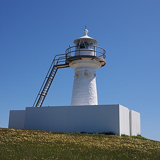
Cape Borda is a headland in the Australian state of South Australia located in the gazetted locality of Cape Borda on the north west tip of Kangaroo Island about 70 km (43 mi) west of the municipal seat of Kingscote. It was named after Jean-Charles de Borda (1733–1799), the French mathematician, physicist, naturalist and sailor, by the Baudin expedition to Australia during January 1803. It has been the site of an operating lighthouse since 1858 and is currently located within the Flinders Chase National Park.

Cape Spencer is a headland in the Australian state of South Australia located on the south west tip of Yorke Peninsula in the gazetted locality of Inneston. It was named after George Spencer, 2nd Earl Spencer by Matthew Flinders during March 1802. It has been the site of an operating navigation aid since 1950 and has been located within the Innes National Park since 1970.

The Backstairs Passage is a strait in South Australia lying between Fleurieu Peninsula on the Australian mainland and Dudley Peninsula on the eastern end of Kangaroo Island. The western edge of the passage is a line from Cape Jervis on Fleurieu Peninsula to Kangaroo Head on Kangaroo Island. The Pages, a group of islets, lie in the eastern entrance to the strait. About 14 km wide at its narrowest, it was formed by the rising sea around 13,000 years ago, at the end of the Pleistocene era, when it submerged the land connecting what is now Kangaroo Island with the Fleurieu Peninsula. Backstairs Passage was named by Matthew Flinders whilst he and his crew on HMS Investigator were exploring and mapping the coastline of South Australia in 1802.
Point Marsden is a headland located on the north coast of Kangaroo Island in South Australia. It was named after William Marsden, Second Secretary to the Admiralty by Matthew Flinders in 1802. It is the western extremity of Nepean Bay and has been the site of a navigation aid since 1915.
Troubridge Point is a headland in the Australian state of South Australia located on the south coast of Yorke Peninsula about 11 kilometres south west of Edithburgh. It is the western end of the opening to Gulf St Vincent.
Rivoli Bay, is a bay located on the south-east coast of the Australian state of South Australia about 311 kilometres south-southeast of the state capital of Adelaide and about 65 kilometres northwest by west of the regional centre of Mount Gambier. It was named in 1802 by the Baudin expedition of 1800-03 after André Masséna, the Duke of Rivoli and Marshal of France. It is one of four 'historic bays' located on the South Australian coast.

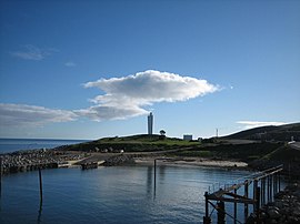
Cape Jervis Lighthouse is a lighthouse located at the headland of Cape Jervis on the most westerly part of the Fleurieu Peninsula on the east coast of Gulf St Vincent in South Australia.

Corny Point is a headland located on the west coast of the Yorke Peninsula in South Australia about 37 kilometres north west of the town of Warooka. The point is described as being "a sloping rocky double projection..." where the "coast on the N[orth] side is low and sandy whereas the coast on the S[outh] side is higher than the point itself." It is the south headland of Hardwicke Bay. It was named by Matthew Flinders on 18 March 1802. The waters adjoining its shoreline are within the Southern Spencer Gulf Marine Park. Since 1882, it has been the site of a navigation aid in the form of a lighthouse.

Cape Willoughby is a headland in the Australian state of South Australia located on the east end of the Dudley Peninsula on Kangaroo Island in the gazetted locality of Willoughby about 22 kilometres south east of the town of Penneshaw.
Cape St Albans is a headland in the Australian state of South Australia located on the north coast of the Dudley Peninsula on Kangaroo Island in the gazetted locality of Willoughby about 18 kilometres south-east of the town of Penneshaw.

Cape Carnot is a headland in the Australian state of South Australia located on the west side of the southern tip of Eyre Peninsula about 30 kilometres south west of the city of Port Lincoln. The Eyre Peninsula has a double tip; the other tip, 3 nautical miles to the east, is Cape Wiles. Cape Carnot is one of a number of coastal features first discovered but not subsequently named by Matthew Flinders in February 1802 and which remained unnamed. In 1913, the Government of South Australia gave the unnamed feature the name proposed by the Baudin expedition when it visited in April 1802. The name Cape Carnot honours Lazare Carnot who is notable as a "French mathematician, general and statesman, who played a prominent part in the French Revolution and the Napoleonic era".
Cape Wiles is a headland located on the west side of the southern tip of Eyre Peninsula in South Australia about 27 kilometres south west of the city of Port Lincoln. The cape is described by one source as being the south east extremity of “a broad promontory” of which Cape Carnot is the south west extremity at a distance of 3 nautical miles to the west. The cape also is the western extremity of Sleaford Bay.

Sleaford Bay is a bay located in the Australian state of South Australia on the southern coast of Eyre Peninsula. It was named by the British navigator, Matthew Flinders in 1802.