Rosetta Head

Last updated

Rosetta Head
South Australia
Victor Harbor Bluff.JPG
Rosetta Head, west side
Australia South Australia location map.svg
Red pog.svg
Rosetta Head
Coordinates 35°35′29″S138°36′14″E / 35.59139°S 138.60389°E / -35.59139; 138.60389 Coordinates: 35°35′29″S138°36′14″E / 35.59139°S 138.60389°E / -35.59139; 138.60389
Postcode(s) 5211
Elevation97 m (318 ft) [1]
LGA(s) City of Victor Harbor

Rosetta Head, known as Kongkengguwar by the Ramindjeri people but more commonly known as The Bluff, is a headland located on the south coast of Fleurieu Peninsula in Encounter Bay, South Australia, within the local government area of the City of Victor Harbor. It is a prominent landmark on the coast, about 77 kilometres (48 miles) south of the state capital of Adelaide, and currently used as a recreational reserve.

Contents

Description

Rosetta Head is located in the suburb of Encounter Bay about 3.9 kilometres (2.4 miles) south-west by south of the centre of Victor Harbor and about 77 kilometres (48 miles) south of Adelaide. [2] When viewed from a platform such as a ship, it appears as being "a grassy mound, 97 metres (318 feet) high, cliffy on its E[ast] side, and covered with granite boulders; it is steep-to on its E[ast] and S[outh] sides." [3] Its southern tip is considered by Australian authorities as being the western extent of Encounter Bay. [4] On its northern side, there is a small wharf which is connected to the adjoining urban area by a road and which adjoins a body of water is known as Rosetta Harbor. On its southern side, there is a small cove called Petrel Cove. [1]

Formation, geology and oceanography

Rosetta Head as a headland was formed when the sea reached its present level 7,500 years ago after sea levels started to rise at the start of the Holocene. As a landform, it is a large domed inselberg which is considered to be "the most prominent feature along Encounter Bay coastline" and whose form is due to its origins via the geological processes of metamorphism and intrusion followed by two phases of erosion; firstly via the action of a northward-moving glacier during the Permian which created the distinctive dome shape and then by wave action from the south due to the sea level rise during the Holocene. When viewed from the adjoining coastline, it is considered to be a typical example of a glacial terrain known as a roche moutonnee. [5] [6] [7] [8] Geologically, Rosetta Head is the result of the intrusion of molten granite (known as Encounter Bay Granite) into a grey metamorphic rock (known as the Kanmantoo group), which was subsequently elevated as part of a mountain-building event known as the Delamerian Orogeny between 475 and 500 million years ago. [7] The water adjoining the base of Rosetta Head drops to a maximum depth of 12.8 metres (42 feet) within a distance of 100 metres (330 feet) of its shore. [1]

History

Aboriginal occupation

Although traditional ownership of Encounter Bay has long been ascribed to the Ramindjeri clan of the Ngarrindjeri people, [9] linguist Rob Amery of the University of Adelaide suggested in a 1998 paper that Kaurna traditional lands "may have extended as far eastward as Encounter Bay and that the occupation of Encounter Bay by the Ramindjeri in the late 1830s may have been a response to the activities of whalers in the area". He also notes that the "Encounter Bay people" mentioned in 1836 by Colonel Light and his party at Rapid Bay in 1836 spoke the Kaurna language. [10]

European discovery and use

Rosetta Head was the site of a whaling station, with its peak used as a look-out point to locate whales. The station was established in 1837 and operated until the early 1860s. [11] [12] [13] The wharf, an adjacent sea wall and the connecting road were completed in 1856 by the SA Government to assist whaling industry activity. The wharf was known as the "Lilliputian Jetty" due to its relatively small size, i.e. 12.7 metres (42 feet) wide by 4.6 metres (15 feet) deep. [14] A mine was established on Rosetta Head in 1863 to search for copper and other minerals until the abandonment of the venture in 1866. [15] A tablet set into a granite boulder located near Rosetta Head's summit was unveiled on 8 April 1902 by the Governor of South Australia, The Right Honourable Hallam, Baron Tennyson, KCMG to commemorate the centenary of the meeting of the European explorers, Matthew Flinders and Nicolas Baudin, in nearby waters. [16]

Naming

The Ramindjeri language name for Encounter Bay was Ramong, [17] [18] although some sources ascribe this name to The Bluff only. [19] The name Kongkengguwar is however more commonly ascribed to The Bluff. [20] [21] [22] [23]

Rosetta Head was given its modern name in 1839 after Rosetta French, the wife of George Fife Angas reportedly by George Gawler, the second Governor of South Australia. [11] [24] The use of the name "The Bluff" which is the most commonly used name for the headland is attributed to whalers operating in the locality prior to the adoption of the name Rosetta Head. [25] [26]

Heritage listings

Rosetta Head was listed on the now-defunct Register of the National Estate on 21 October 1980. [27] It was listed on the South Australian Heritage Register on 1 September 1983. [28]

Current land use

Rosetta Head is used as a public recreation reserve which is managed by the City of Victor Harbor. A walking trail ascends to the summit where views of the adjoining coastline including the Victor Harbor urban area and the nearby islands are available as well as the opportunity to observe southern right whales in the nearby waters between the months of May and November. As of 2007, a proposal existed to connect the Rosetta Head walking trail to the Heysen Trail to its west via a trail following the coastline. [15] [29] [30] A sandy beach on the north side of Rosetta Head is notable as a site for swimming while the wharf is used for recreational fishing. A sandy beach on the south side of the head at Petrel Cove is known for its surfing and surf fishing but is considered to be a hazardous location for swimming. The sea around Rosetta Head is a popular site for recreational diving and is notable as a place to see Leafy sea dragons. [31] [32] [33]

Related Research Articles

Lincoln National Park Protected area in South Australia

Lincoln National Park is a protected area in the Australian state of South Australia located about 249 kilometres (155 mi) west of the state capital of Adelaide and about 9.5 kilometres (5.9 mi) south of the municipal seat of Port Lincoln. It consists of a mainland area on the Jussieu Peninsula on the south eastern tip of Eyre Peninsula and a number of nearby islands. The national park contains significant sites of natural, indigenous and early European heritage.

The Kaurna people are a group of Aboriginal people whose traditional lands include the Adelaide Plains of South Australia. They were known as the Adelaide tribe by the early settlers. Kaurna culture and language were almost completely destroyed within a few decades of the British colonisation of South Australia in 1836. However, extensive documentation by early missionaries and other researchers has enabled a modern revival of both language and culture. The phrase Kaurna meyunna means "Kaurna people".

Victor Harbor, South Australia City in South Australia

Victor Harbor is a town in the Australian state of South Australia located within the City of Victor Harbor on the south coast of the Fleurieu Peninsula, about 82 kilometres (51 mi) south of the state capital of Adelaide. The town is the largest population centre on the peninsula, with an economy based upon agriculture, fisheries and various industries. It is also a highly popular tourist destination, with the area's population greatly expanded during the summer holidays, usually by Adelaide locals looking to escape the summer heat.

Gulf St Vincent A large inlet of water on the southern coast of South Australia between the Yorke Peninsula and the Fleurieu Peninsula

Gulf St Vincent, sometimes referred to as St Vincent Gulf, St Vincent's Gulf or Gulf of St Vincent, is the eastern of two large inlets of water on the southern coast of Australia, in the state of South Australia, the other being the larger Spencer Gulf, from which it is separated by Yorke Peninsula. On its eastern side the gulf is bordered by the Adelaide Plains and the Fleurieu Peninsula. To the south it is defined by a line from Troubridge Point on Yorke Peninsula to Cape Jervis on Fleurieu Peninsula. Its entrances from the southwest are from Investigator Strait, and to the southeast from Backstairs Passage, which separate Kangaroo Island from the mainland. Adelaide, the South Australian capital, lies midway along the gulf's east shore. Other towns located on the gulf, from west to east include Edithburgh, Port Vincent, Ardrossan and Port Wakefield and Normanville.

Encounter Bay Bay on the south central coast of South Australia

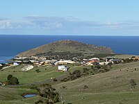
Encounter Bay, once known as Ramong to the Ramindjeri people, is a bay in the Australian state of South Australia located on the state's south central coast about 100 kilometres (62 mi) south of the state capital of Adelaide. It was named by Matthew Flinders after his encounter on 8 April 1802 with Nicolas Baudin, the commander of the Baudin expedition of 1800–03. It is the site of both the mouth of the River Murray and the regional city of Victor Harbor. It is one of four "historic bays" located on the South Australian coast.

Port Elliot, South Australia Town in South Australia

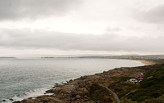
Port Elliot is a town in South Australia toward the eastern end of the south coast of the Fleurieu Peninsula. It is situated on the sheltered Horseshoe Bay, a small bay off the much larger Encounter Bay. Pullen Island lies outside the mouth of the bay. At the 2006 census, Port Elliot had a population of 1,754, although this section of the coast is now built up almost all the way from Goolwa to Victor Harbor.

The Ramindjeri or Raminjeri people were an Aboriginal Australian people forming part of the Kukabrak grouping now otherwise known as the Ngarrindjeri people. They were the most westerly Ngarrindjeri, living in the area around Encounter Bay and Goolwa in southern South Australia, including Victor Harbor and Port Elliot. In modern native title actions a much more extensive territory has been claimed.

Kaurna is a Pama-Nyungan language historically spoken by the Kaurna peoples of the Adelaide Plains of South Australia. The Kaurna peoples are made up of various tribal clan groups, each with their own parnkarra district of land and local dialect. These dialects were historically spoken in the area bounded by Crystal Brook and Clare in the north, Cape Jervis in the south, and just over the Mount Lofty Ranges. Kaurna ceased to be spoken on an everyday basis in the 19th century and the last known native speaker, Ivaritji, died in 1929. Language revival efforts began in the 1980s, with the language now frequently used for ceremonial purposes, such as dual naming and welcome to country ceremonies.

Port Noarlunga, South Australia Coastal suburb of Adelaide, South Australia

Port Noarlunga is a suburb in the City of Onkaparinga, South Australia. It is a small sea-side suburb, population 2,918, about 30 kilometres to the south of the Adelaide city centre and was originally created as a sea port. This area is now popular as a holiday destination or for permanent residents wishing to commute to Adelaide or work locally. There is a jetty that connects to a 1.6 kilometres long natural reef that is exposed at low tide. The beach is large and very long and has reasonable surfing in the South Port area whose name is taken from its location - "South of the Port".

Tjilbruke Creation being in Kaurna (an Aboriginal Australian group) mythology

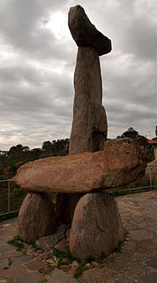
Tjilbruke is an important creation ancestor for the Kaurna people of the Adelaide plains in the Australian state of South Australia. Tjilbruke was a Kaurna man, who appeared in Kaurna Dreaming dating back about 11,000 years. The Tjilbruke Dreaming Track or Tjilbruke Dreaming Trail is a major Dreaming trail, which connects sites from within metropolitan Adelaide southwards as far as Cape Jervis, some of which are Aboriginal sacred sites of great significance.

District Council of Yankalilla Local government area in South Australia

The District Council of Yankalilla is a local government area centred on the town of Yankalilla on the Fleurieu Peninsula in South Australia.

Cape Borda Place in South Australia

Cape Borda is a headland in the Australian state of South Australia located in the gazetted locality of Cape Borda on the north west tip of Kangaroo Island about 70 km (43 mi) west of the municipal seat of Kingscote. It was named after Jean-Charles de Borda (1733–1799), the French mathematician, physicist, naturalist and sailor, by the Baudin expedition to Australia during January 1803. It has been the site of an operating lighthouse since 1858 and is currently located within the Flinders Chase National Park.

Vivonne Bay (South Australia)

Vivonne Bay is a bay in the Australian state of South Australia located on the south coast of Kangaroo Island about 61 kilometres (38 mi) from Kingscote, the island's main town, and which was named by the members of Baudin expedition to Australia who visited the bay in January 1803. In a survey of 10,000 beaches by Professor Andrew Short, director of Sydney University's marine studies centre, the beach at Vivonne Bay was adjudged as one of the best in Australia.

Cape Spencer (South Australia) Place in South Australia

Cape Spencer is a headland in the Australian state of South Australia located on the south west tip of Yorke Peninsula in the gazetted locality of Inneston. It was named after George Spencer, 2nd Earl Spencer by Matthew Flinders during March 1802. It has been the site of an operating navigation aid since 1950 and has been located within the Innes National Park since 1970.

Backstairs Passage

The Backstairs Passage is a strait in South Australia lying between Fleurieu Peninsula on the Australian mainland and Dudley Peninsula on the eastern end of Kangaroo Island. The western edge of the passage is a line from Cape Jervis on Fleurieu Peninsula to Kangaroo Head on Kangaroo Island. The Pages, a group of islets, lie in the eastern entrance to the strait. About 14 km wide at its narrowest, it was formed by the rising sea around 13,000 years ago, at the end of the Pleistocene era, when it submerged the land connecting what is now Kangaroo Island with the Fleurieu Peninsula. Backstairs Passage was named by Matthew Flinders whilst he and his crew on HMS Investigator were exploring and mapping the coastline of South Australia in 1802.

Encounter Bay, South Australia Suburb of Victor Harbor, South Australia

Encounter Bay is a locality in the Australian state of South Australia located about 87 kilometres (54 mi) south of the state capital of Adelaide and about 4 kilometres (2.5 mi) south-west of the municipal seat of Victor Harbor.

Cape Gantheaume Place in South Australia

Cape Gantheaume is a headland located on the south coast of Kangaroo Island in South Australia. It was named after Vice admiral Honoré Joseph Antoine Ganteaume (1755–1818) by the Baudin expedition to Australia during 1803. It is currently located within the protected area known as the Cape Gantheaume Wilderness Protection Area.

Seal Island (Encounter Bay) Small island of South Australia

Seal Island, also known as Seal Rock, is an island in the Australian state of South Australia located in Encounter Bay off the south coast of Fleurieu Peninsula approximately 2.7 kilometres south-east of Victor Harbor. It is located with the boundaries of the following protected areas - the West Island Conservation Park and the Encounter Marine Park.

Guichen Bay

Guichen Bay, is a bay located on the south-east coast of the Australian state of South Australia about 115 kilometres northwest of the regional city of Mount Gambier and about 270 kilometres south-southeast of the state capital of Adelaide. It was named in 1802 by the Baudin expedition of 1800-03 after Luc Urbain de Bouëxic, comte de Guichen. The town of Robe is located at the southern end of the bay.

Moncrieff Bay

Moncrieff Bay is a bay in the Australian state of South Australia located at the east end of the Dudley Peninsula on Kangaroo Island in the gazetted locality of Willoughby overlooking Backstairs Passage about 106 kilometres (66 mi) south-west of the state capital of Adelaide and about 47 kilometres (29 mi) south-east of the municipal seat of Kingscote.

References

  1. 1 2 3 South Australia. Department of Marine and Harbors (1985), The Waters of South Australia a series of charts, sailing notes and coastal photographs, Dept. of Marine and Harbors, South Australia, pp. Charts 10, ISBN   978-0-7243-7603-2
  2. "Suburbs Map - District" (PDF). City of Victor Harbor. Retrieved 31 July 2015.
  3. Sailing Directions (Enroute), Pub. 175: North, West, and South Coasts of Australia (PDF). Sailing Directions . United States National Geospatial-Intelligence Agency. 2017. p. 227.
  4. "Seas and Submerged Lands (Historic Bays) Proclamation 2006". Commonwealth of Australia. Retrieved 29 July 2014.
  5. Robinson, A. C.; Armstrong, D. M., eds. (1999). A Biological Survey of Kangaroo Island, South Australia, 1989 & 1990 (PDF). Adelaide, SA: Heritage and Biodiversity Section, Department for Environment, Heritage and Aboriginal Affairs, South Australia. p. 26. ISBN   0-7308-5862-6 . Retrieved 1 May 2014.
  6. "Rosetta Head, Franklin Pde, Encounter Bay, SA, Australia (Register of the National Estate (Non-statutory archive))". Department of the Environment. 21 October 1980. Retrieved 29 June 2014.
  7. 1 2 Noel Hiern, Field Guide Subcommittee, Geological Society of Australia (South Australian Division) (2012). "Geological trail VICTOR HARBOR, A self-drive geological trail" (PDF). Government of South Australia, Department for Manufacturing, Innovation, Trade, Resources and Energy. pp. 2–3. Archived from the original (PDF) on 11 April 2013. Retrieved 15 August 2014.{{cite web}}: CS1 maint: multiple names: authors list (link)
  8. "Geological Sites, The Bluff". City of Victor Harbor. Retrieved 16 August 2014.
  9. "Map of Indigenous Australia". AIATSIS. Retrieved 17 November 2020.
  10. Amery, Rob (2016). Warraparna Kaurna!: Reclaiming an Australian language (PDF). University of Adelaide Press. p. 5. doi:10.20851/kaurna. ISBN   978-1-925261-25-7 . Retrieved 17 November 2020.
  11. 1 2 Webb, Lucy (10 October 1936). "Historic Victor Harbor". The Mail. p. 10. Retrieved 29 June 2014.
  12. "South Australian Company". South Australian Gazette and Colonial Register. 3 June 1837. p. 4. Retrieved 16 August 2014.
  13. "The Romantic South, some early history, part III". The Register. 15 September 1928. p. 5. Retrieved 16 August 2014.
  14. Collins, Neville C (2005), The jetties of South Australia : past and present, Neville Collins, p. 192, ISBN   978-0-9580482-2-4
  15. 1 2 "The Bluff Summit Walk" (PDF). City of Victor Harbor. Archived (PDF) from the original on 5 May 2005. Retrieved 29 June 2014.
  16. "The meeting of Flinders and Baudin, Commemorated at the Bluff, An interesting event". The Register. 9 April 1902. p. 6. Retrieved 24 July 2014.
  17. "Ramindjeri". Mobile Language Team. 17 November 2020. Retrieved 17 November 2020.
  18. "Ramindjeri (SA)". South Australian Museum . Retrieved 17 November 2020.
  19. "Encounter Bay (1840-1848)". German Missionaries in Australia. Griffith University . Retrieved 17 November 2020.
  20. "Places". Great Southern Reef. Retrieved 17 November 2020.
  21. Victor Harbor Council (20 June 2017). "Development Plan". Government of South Australia.{{cite journal}}: Cite journal requires |journal= (help)
  22. "The Romantic South, some early history, part IV". The Register. 22 September 1928. p. 5. Retrieved 16 August 2014.
  23. "Kongkengguwar". Gazetteer of Australia online. Geoscience Australia, Australian Government.
  24. "Commemoration Address". The Register. 15 April 1927. p. 8. Retrieved 16 August 2014.
  25. Newland, Simpson (2 December 1893). "Paving the way, A romance of the Australian bush, Part 1 - On the coast". South Australian Chronicle. p. 10. Retrieved 15 August 2014.
  26. "'Paving the way', The romance of Victor Harbor". The Register. 19 September 1924. p. 11. Retrieved 16 August 2014.
  27. "Rosetta Head, Franklin Pde, Encounter Bay, SA, Australia - listing on the now-defunct Register of the National Estate (Place ID 7472)". Australian Heritage Database . Australian Government. 21 October 1980. Retrieved 27 January 2019.
  28. "The Bluff Historic Site". Government of South Australia. 1 September 1983. Retrieved 11 January 2019. Quote - "The Bluff (Rosetta Head) Historic Site, including the Jetty & Whaling Station Site"
  29. "City of Victor Harbor Reserves" (PDF). City of Victor Harbor. Retrieved 14 August 2014.
  30. City of Victor Harbor Recreation and Open Space Study: Recreation and Open Space Strategic Directions Report Volume 2 – FINAL DRAFT (PDF). Suter Planners. February 2007. p. 51.
  31. "Petrel Cove, unpatrolled beach". Surf Life Saving Australia. Retrieved 16 August 2014.
  32. "Rosetta Head, unpatrolled beach". Surf Life Saving Australia. Retrieved 14 August 2014.
  33. Neville Coleman; Nigel Marsh. "Victor Harbour (sic)". Underwater Australia. Neville Coleman. Archived from the original on 2 February 2013. Retrieved 14 August 2014.