McCracken, South Australia

Last updated

McCracken
Victor Harbor,  South Australia
1537782689027 View from Kleinigs Hill Lookout.jpg
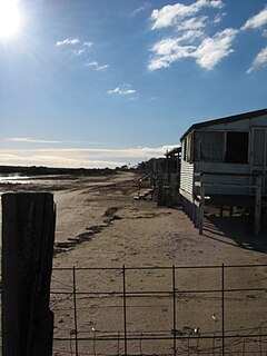
Kleinigs Hill Lookout, McCracken
Australia South Australia location map.svg
Red pog.svg
McCracken
Coordinates 35°32′08″S138°37′53″E / 35.53545°S 138.63136°E / -35.53545; 138.63136 Coordinates: 35°32′08″S138°37′53″E / 35.53545°S 138.63136°E / -35.53545; 138.63136 [1]
Population1,958 (2016 census) [2]
Postcode(s) 5211
Location68 km (42 mi) S of Adelaide
LGA(s) City of Victor Harbor [1]
Region Fleurieu and Kangaroo Island [3]
State electorate(s) Finniss
Federal Division(s) Mayo
Suburbs around McCracken:
Hindmarsh Valley Hindmarsh Valley Hayborough
Victor Harbor McCracken Hayborough
Victor Harbor Encounter Bay
Footnotes [4]

McCracken is a locality in the Australian state of  South Australia located about 68 kilometres (42 mi) south of the state capital of Adelaide in the local government area of the City of Victor Harbor. [1]

Suburbs and localities are the names of geographic subdivisions in Australia, used mainly for address purposes. The term locality is used in rural areas, while the term suburb is used in urban areas. Australian postcodes closely align with the boundaries of localities and suburbs.

South Australia State of Australia

South Australia is a state in the southern central part of Australia. It covers some of the most arid parts of the country. With a total land area of 983,482 square kilometres (379,725 sq mi), it is the fourth-largest of Australia's states and territories by area, and fifth largest by population. It has a total of 1.7 million people, and its population is the second most highly centralised in Australia, after Western Australia, with more than 77 percent of South Australians living in the capital, Adelaide, or its environs. Other population centres in the state are relatively small; Mount Gambier, the second largest centre, has a population of 28,684.

Adelaide city centre Suburb of Adelaide, South Australia

Adelaide city centre is the innermost locality of Greater Adelaide, the capital city of South Australia. It is known by locals simply as "The City" or "Town" to distinguish it from Greater Adelaide and from the City of Adelaide. The locality is split into two key geographical distinctions: the city "square mile", bordered by North, East, South and West Terraces; and the section of the parklands south of the River Torrens which separates the built up part of the city from the surrounding suburbs and North Adelaide.

Contents

The location of McCracken TheLocationOfMcCracken.jpg
The location of McCracken

Demographics

The 2006 census by the Australian Bureau of Statistics counted 1,549 persons in McCracken on census night. Of these, 47.3% were male and 52.7% were female.

Australian Bureau of Statistics Australias principal government institution in charge of statistics and census data

The Australian Bureau of Statistics (ABS) is the independent statistical agency of the Government of Australia. The ABS provides key statistics on a wide range of economic, population, environmental and social issues, to assist and encourage informed decision making, research and discussion within governments and the community.

The majority of residents (77%) are of Australian birth, with an additional 13.2% declaring England as their country of birth.

England Country in north-west Europe, part of the United Kingdom

England is a country that is part of the United Kingdom. It shares land borders with Wales to the west and Scotland to the north-northwest. The Irish Sea lies west of England and the Celtic Sea lies to the southwest. England is separated from continental Europe by the North Sea to the east and the English Channel to the south. The country covers five-eighths of the island of Great Britain, which lies in the North Atlantic, and includes over 100 smaller islands, such as the Isles of Scilly and the Isle of Wight.

The average age of McCracken residents is higher than the greater Australian population. 79.1% of residents were over 25 years in 2006, compared to the Australian average of 66.5%; and 20.9% were younger than 25 years, compared to the Australian average of 33.5%.

Community

The local newspapers are the Independent Weekly and the Times.[ citation needed ]


Amenities

McCracken is notable as the location of the McCracken Country Club & Resort.[ according to whom? ]

Cootamundra Reserve lies on the northeast boundary of the suburb.[ citation needed ]

Transportation

McCracken is serviced by Hindmarsh Road, linking the suburb to Victor Harbor. Victor Harbor Road forms the eastern boundary of McCracken.[ citation needed ]

Related Research Articles

Thorngate, South Australia Suburb of Adelaide, South Australia

Thorngate is an inner northern suburb of Adelaide, South Australia. It is located in the City of Prospect.

Athol Park, South Australia Suburb of Adelaide, South Australia

Athol Park is a north-western suburb of Adelaide, South Australia. It is located in the City of Charles Sturt.

Cheltenham, South Australia Suburb of Adelaide, South Australia

Cheltenham is a suburb of Adelaide, South Australia. It is located in the City of Charles Sturt.

McLaren Vale, South Australia Suburb of Adelaide, South Australia

McLaren Vale is a locality in the Australian state of South Australia located within the Adelaide metropolitan area about 33 kilometres (21 mi) south of the Adelaide city centre and about 9 kilometres (5.6 mi) south of the municipal seat at Noarlunga Centre.

Valley View, South Australia Suburb of Adelaide, South Australia

Valley View is a suburb of Adelaide, South Australia. It is located mainly in the City of Salisbury and the City of Port Adelaide Enfield, with part also in the City of Tea Tree Gully. The suburb's boundaries are defined by the intersection of Walkleys, Grand Junction and North East Roads in the south, and Wright and Kelly Roads in the north and east.

Sellicks Beach, South Australia Suburb of City of Onkaparinga, South Australia

Sellicks Beach is an outer southern suburb of Adelaide, South Australia which is located in the local government area of the City of Onkaparinga and is the southernmost extent of the Adelaide metropolitan area. At the 2006 census, Sellicks Beach had a population of 2,339.

Hindmarsh, South Australia Suburb of Adelaide, South Australia

Hindmarsh is an inner suburb of Adelaide, South Australia. It is located in the City of Charles Sturt.

Aldinga Beach, South Australia Suburb of City of Onkaparinga, South Australia

Aldinga Beach is an outer southern suburb of Adelaide, South Australia. It lies within the City of Onkaparinga and has the postcode 5173. At the 2011 census, Aldinga Beach had a population of 9,697.

Middle Beach, South Australia Town in South Australia

Middle Beach is a small town in South Australia located about 40 kilometres northwest of the Adelaide city centre. It is located in the Adelaide Plains Council.

Devon Park, South Australia Suburb of Adelaide, South Australia

Devon Park is an inner northern suburb of Adelaide, South Australia. It is located in the cities of Port Adelaide Enfield and Charles Sturt beside the Gawler railway line near, but not meeting, the intersection of Torrens Road and Churchill Road.

Waitpinga, South Australia Town in South Australia

Waitpinga is a locality in the Australian state of South Australia located about 75 kilometres south of the state capital of Adelaide and about 10 kilometres southwest of the municipal seat of Victor Harbor.

Hayborough Suburb of City of Victor Harbor, South Australia

Hayborough is a north-eastern suburb of the South Australian town of Victor Harbor, located on the south coast of Fleurieu Peninsula.

Encounter Bay, South Australia Suburb of Victor Harbor, South Australia

Encounter Bay is a locality in the Australian state of South Australia located about 87 kilometres (54 mi) south of the state capital of Adelaide and about 4 kilometres (2.5 mi) south-west of the municipal seat of Victor Harbor.

Hynam, South Australia Town in South Australia

Hynam is a town and locality in the Australian state of South Australia located in the state's south-east within the Limestone Coast region on the border with the state of Victoria about 302 kilometres south east of the state capital of Adelaide and about 11 kilometres east of the municipal seat of Naracoorte.

Nangwarry, South Australia Town in South Australia

Nangwarry is a town and a locality in the Australian state of South Australia located about 352 kilometres (219 mi) south-east of the state capital of Adelaide and about 32 kilometres (20 mi) north-west of the regional centre of Mount Gambier.

Globe Derby Park is a suburb of Adelaide, South Australia. It is located in the City of Salisbury.

Munno Para, South Australia Suburb of Adelaide, South Australia

Munno Para is a northern suburb of Adelaide, South Australia. It is located in the City of Playford.

Mount Jagged, South Australia Suburb of Alexandrina Council, City of Victor Harbor, South Australia

Mount Jagged is a locality in the Australian state of South Australia located about 55 kilometres south of the state capital of Adelaide and about 16 kilometres north-west and 15 kilometres north respectively of the municipal seats of Goolwa and Victor Harbor.

Chiton, South Australia Suburb of Alexandrina Council, South Australia

Chiton is a locality in the Australian state of South Australia located on the south coast of Fleurieu Peninsula about 67 kilometres (42 mi) south of the state capital of Adelaide and about 11 kilometres (6.8 mi) west of the municipal seat of Goolwa.

Hindmarsh Tiers, South Australia Suburb of City of Victor Harbor, South Australia

Hindmarsh Tiers is a locality in the Australian state of South Australia located about 55 kilometres (34 mi) south of the state capital of Adelaide and about 15 kilometres (9.3 mi) north of the municipal seat of Victor Harbor.

References

  1. 1 2 3 "Search results for 'McCracken, LOCB' with the following datasets selected - 'Suburbs and localities', 'Counties', 'Local Government Areas', 'SA Government Regions' and 'Gazetteer'". Location SA Map Viewer. South Australian Government. Retrieved 9 March 2019.
  2. Australian Bureau of Statistics (27 June 2017). "McCracken (State Suburb)". 2016 Census QuickStats. Retrieved 20 April 2018. Blue pencil.svg
  3. "Fleurieu Kangaroo Island SA Government region" (PDF). The Government of South Australia. Retrieved 17 April 2017.
  4. "Suburbs Map - District" (PDF). City of Victor Harbor. Retrieved 31 July 2015.