Encounter Bay is a bay in the Australian state of South Australia located on the state's south central coast about 100 kilometres (62 mi) south of the state capital of Adelaide. It was named by Matthew Flinders after his encounter on 8 April 1802 with Nicolas Baudin, the commander of the Baudin expedition of 1800–03. It is the site of both the mouth of the River Murray and the regional city of Victor Harbor. It is one of four "historic bays" located on the South Australian coast.

West Island is a 10 hectares granite island lying 0.8 kilometres off the southern coast of the Fleurieu Peninsula, South Australia, 7 kilometres south-west of the town of Victor Harbor. It rises to a maximum height of about 40 metres in the south-west. Its main conservation value lies in its seabird colonies.
Cape Gantheaume is a headland located on the south coast of Kangaroo Island in South Australia. It was named after Vice admiral Honoré Joseph Antoine Ganteaume (1755–1818) by the Baudin expedition to Australia during 1803. It is currently located within the protected area known as the Cape Gantheaume Wilderness Protection Area.

Nobby Islet is an islet located in the Great Australian Bight off the south coast of Kangaroo Island in the Australian state of South Australia approximately 50 kilometres south-west of Kingscote. It is currently part of the Seal Bay Conservation Park.

Nepean Bay is a bay located on the north-east coast of Kangaroo Island in the Australian state of South Australia about 130 kilometres south-south-west of Adelaide. It was named by the British navigator, Matthew Flinders, after Sir Evan Nepean on 21 March 1802.

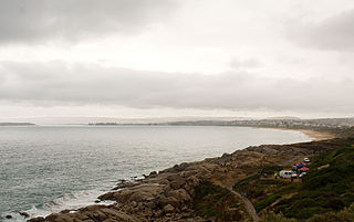
Rosetta Head, known as Kongkengguwar by the Ramindjeri people but more commonly known as The Bluff, is a headland located on the south coast of Fleurieu Peninsula in Encounter Bay, South Australia, within the local government area of the City of Victor Harbor. It is a prominent landmark on the coast, about 77 kilometres south of the state capital of Adelaide, and currently used as a recreational reserve.
Seal Island is an island located in Investigator Strait off the south coast of Yorke Peninsula in the Australian state of South Australia about 7 kilometres south south-west of Stenhouse Bay. Since 1972, it has been part of the Althorpe Islands Conservation Park.
Haystack Island is an island located in Investigator Strait off the south coast of Yorke Peninsula in the Australian state of South Australia about 6 kilometres south-west of Stenhouse Bay. Since 1972, it has been part of the Althorpe Islands Conservation Park.
Lacepede Bay is a bay in the Australian state of South Australia located on the state's south-east coast about 140 kilometres northwest of Mount Gambier and about 240 kilometres southeast of Adelaide. It was named in 1802 by the Baudin expedition of 1800-03 after Bernard Germain de Lacépède, the French naturalist. It is one of four ‘historic bays’ located on the South Australian coast.

Anxious Bay is a bay in the Australian state of South Australia located on the west coast of Eyre Peninsula about 275 kilometres west north-west of Adelaide. It was named by Matthew Flinders on 21 February 1802. It is one of four ‘historic bays’ located on the South Australian coast.

Point Labatt is a headland located on the west coast of Eyre Peninsula in the Australian state of South Australia about 39 kilometres south by east of Streaky Bay. It is notable as one of the largest Australian mainland breeding sites for Australian sea lions. The land and the sea adjoining Point Labatt is part of three protected areas - the Point Labatt Conservation Park, the Point Labatt Aquatic Reserve and the West Coast Bays Marine Park.

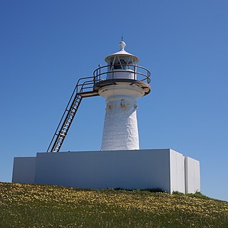
Cape Willoughby is a headland in the Australian state of South Australia located on the east end of the Dudley Peninsula on Kangaroo Island in the gazetted locality of Willoughby about 22 kilometres south east of the town of Penneshaw.
Cape St Albans is a headland in the Australian state of South Australia located on the north coast of the Dudley Peninsula on Kangaroo Island in the gazetted locality of Willoughby about 18 kilometres south-east of the town of Penneshaw.
Beatrice Islets are pair of islets in the Australian state of South Australia located in Nepean Bay on the north coast of Kangaroo Island about 4 kilometres east of Kingscote. The islets and adjoining intertidal areas are notable as habitat for bird life. The islet pair has enjoyed protected area status since 1909 and since at least 1972, have been part of the Beatrice Islet Conservation Park. During either the 1960s or the 1970s, the islets were extensively damaged by an exercise to remove an infestation of South African boxthorn.
Busby Islet is an islet in the Australian state of South Australia located in Nepean Bay on the north coast of Kangaroo Island about 2 kilometres north of the municipal seat of Kingscote. The islet and adjoining areas are notable as habitat for bird life. The islet has enjoyed protected area status since 1909 and since at least 1972, have been part of the Busby Islet Conservation Park.

Waldegrave Islands is an island group in the Australian state of South Australia located in the Investigator Group about 2.5 kilometres northwest by west of Cape Finniss on the west coast of Eyre Peninsula. The group consists of Waldegrave Island, Little Waldegrave Island and according to some sources, a pair of rocks known as the Watchers. The group is notable as a breeding site for Australian sea lions and Cape Barren geese. The group has enjoyed protected area status since the 1960s and as of 1972 has been part of the Waldegrave Islands Conservation Park.
Point Weyland is a headland located on the west coast of Eyre Peninsula in South Australia about 4 kilometres west south-west of the town of Venus Bay and about 51 kilometres north north-west of the town of Elliston. The point which is located within Anxious Bay is the southern extremity of the opening to Venus Bay. The point is described by one source as being "a conspicuous cliffy point, 89 m (292 ft) high, stands close S[outh] W[est] of the entrance of Venus Bay" and "rises to a height of 96 m (315 ft), close N[orth] and slopes inland toward Venus Bay". It was named by Matthew Flinders on 10 February 1802. The point has been within the boundary of the Venus Bay Conservation Park since 1977 while the waters adjoining its shoreline have been within a habitat protection zone in the West Coast Bays Marine Park since 2012.
Slade Point is a headland in the Australian state of South Australia located on the west coast of Eyre Peninsula in the locality of Sceale Bay about 29 kilometres (18 mi) south of the town of Streaky Bay. The point is the northern extremity of Searcy Bay and the southern extremity of a promontory that separates Searcy Bay in the south east from Sceale Bay in the north west. While it is within the coastline first charted by Matthew Flinders on 9 February 1802, it is not named by Flinders possibly due to the coastline being obscured by a thick haze. Slade Point was named in 1908 after “the late Mr. W. E. Slade” who served as the Assistant Engineer of Harbours in the South Australian Government. The cape has adjoined the boundary of the Cape Blanche Conservation Park since 2012 while the waters adjoining its shoreline have been within a habitat protection zone in the West Coast Bays Marine Park also since 2012.
Cape Blanche is a headland located on the west coast of Eyre Peninsula in South Australia about 25 kilometres south south-west of the town of Streaky Bay and about 4 kilometres west of the town of Sceale Bay.
Jones Island is an island in the Australian state of South Australia located at the mouth of Baird Bay in the north end of Anxious Bay about 45 kilometres south-southeast of the town of Streaky Bay on the west coast of Eyre Peninsula. The island is notable as a breeding site for Australian sea lions and Australian pelicans. The island has enjoyed protected area status since 1967 and as of 1972, it has been part of the Baird Bay Islands Conservation Park.
