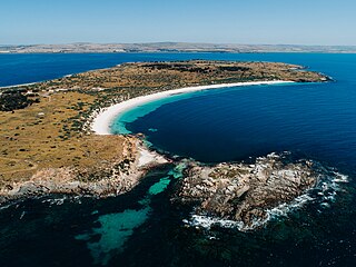
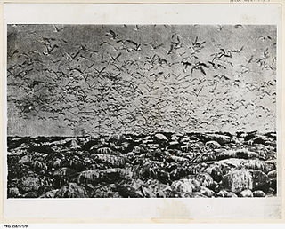
English Island is an island off the coast of Eyre Peninsula in South Australia. It is a part of the Sir Joseph Banks Group and close to Sibsey Island. The island is most notable for its large colony of sea lions, and for a secession movement started by the eccentric and self-styled "Sir Ralph Styles of English Island" in 1954.

The Kensington Oval is located on 344 The Parade, Kensington, South Australia. Now used primarily for cricket in South Australia, the venue was once Adelaide's premier athletics facility and known as Olympic Sports Field.

Louth Bay is a town and locality in the Australian state of South Australia. It is named after the bay named by Matthew Flinders on 26 February 1802 which itself is derived from a place in Lincolnshire. At the 2006 census, Louth Bay had a population of 408.

Wardang Island, also known as Waralti is a low-lying 20 km2 island in the Spencer Gulf close to the western coast of the Yorke Peninsula, South Australia. It acts as a natural breakwater, protecting the former grain port of Port Victoria and providing a sheltered anchorage. After European colonisation it was used for the grazing of sheep, for rabbit disease research, was quarried for lime to supply the lead smelter at Port Pirie and is currently leased to the island's traditional owners: the Narungga. The much smaller Goose Island and the other rocks and islets in the Goose Island Conservation Park lie off the northern end. Anyone seeking to visit the island must obtain prior permission from the Point Pearce Community Council.

The Sir Joseph Banks Group is an archipelago in the Australian state of South Australia located in Spencer Gulf about 20 kilometres (12 mi) off the eastern coast of the Eyre Peninsula. It consists of 21 islands of which eighteen are in the Sir Joseph Banks Group Conservation Park while the surrounding waters are in the Sir Joseph Banks Group Marine Park. It is considered to be an important seabird breeding site.
Wooltana Station, most commonly known as Wooltana, is a pastoral lease that operates as a sheep station in outback South Australia. It lies on what were formerly the lands of the Pilatapa.
Lipson Cove is a tranquil sandy bay in the Australian state of South Australia on the east coast of Eyre Peninsula overlooking Spencer Gulf. It features in the 2012 book 101 Best Australian Beaches by Andy Short and Brad Farmer.

Louth Island is a 135 ha island located in Louth Bay, Spencer Gulf, South Australia. The island is privately owned, and has previously been used for the grazing of sheep and mining of guano. The island has an old building with sleeping quarters, several beaches, inshore rocky reef and a boat anchorage. It is 17.5 km NNE of Port Lincoln and is easily accessible by boat. The indigenous name for the island is Yorunu.
Grantham Island is an uninhabited island occupying 51 hectares of Proper Bay, Spencer Gulf, South Australia. The nearest geographical feature on the mainland is Murray Point, which is also undeveloped. The island was named by explorer Matthew Flinders on 25 February 1802, after the municipal and parliamentary borough of Grantham, Lincolnshire, England. It lies 3 kilometres south of the Port Lincoln marina and is well vegetated.

Boston Island is a 960-hectare (2,400-acre) privately owned island in Boston Bay, Spencer Gulf, South Australia. It has been primarily used for grazing sheep and was also once the location of a proposed township called Kerrillyilla at the southern end of the island. In 2009, the island was rezoned to allow for future residential and tourism development. As of 2009, it is owned by the former mayor of Port Lincoln, Peter Davis. Davis' development plans include up to 1,000 residential allotments, three tourism developments and an inland marina. Prior to rezoning, there had been little interest expressed in the development plan, despite the then mayor's enthusiasm.

Taylor Island, also known as Taylor's Island, is the largest in a group of seven islands located between the Eyre Peninsula mainland and Thistle Island in the mouth of Spencer Gulf, South Australia. It was named by British explorer Matthew Flinders in 1802, after the loss of William Taylor, a midshipman and master's mate to John Thistle. The remaining islands in the group are also named after lost members of Flinders' expedition: Little Island, Lewis Island, Smith Island, Hopkins Island and Grindal Island. Taylor's Island has been used principally for the grazing of sheep while its surrounding waters are well regarded fishing grounds.
Hopkins Island is an island located in Spencer Gulf off the east coast of Jussieu Peninsula on Eyre Peninsula in South Australia approximately 32 km (20 mi) south-east of Port Lincoln. It was named by Matthew Flinders in memory of John Hopkins who was one of the eight crew lost from a cutter that capsized on 21 February 1802. Since 2004, the island has been part of the Memory Cove Wilderness Protection Area.
Kappawanta is both a pastoral lease that operates as a sheep station and a gazetted bounded locality in South Australia.

Parakylia Station is a pastoral lease that once operated as a sheep station but now operates as a cattle station in outback South Australia.
Charles Christian Dutton was a pastoralist in the Colony of South Australia who disappeared, believed murdered by Aboriginal people, while driving cattle from Port Lincoln to Adelaide in July 1842.

Dangerous Reef is an island and reef system located in the Spencer Gulf in the Australian state of South Australia about 32.5 kilometres (20.2 mi) east-southeast of the city, Port Lincoln. It is the southernmost member of the Sir Joseph Banks Group. It has been the site of a navigation aid since 1911. It is notable as the site of a breeding colony of Australian sea lions. The waters adjoining its shore are notable as a place to view great white sharks to the extent that it was both a popular gamefishing and shark cage diving venue during the twentieth century, and was used to film footage for the following motion pictures – Blue Water White Death and Jaws. The island has enjoyed protected area status since 1900 and it has been part of the Sir Joseph Banks Group Conservation Park since 1989.
Fitzgerald Bay is a large bay located between Point Lowly and Backy Point in South Australia's upper Spencer Gulf. The bay's shoreline consists mostly of pebble beaches and sparse grey mangroves. In the 2000s the bay was used for the farming of yellowtail kingfish until their closure circa 2011 in response to high levels of fish mortality. Understanding of the environmental impacts of yellowtail kingfish farming is limited. As of 2021, fish farming has not returned to Fitzgerald Bay, but aquaculture zones remain in place, and Clean Seas is authorised to restock fish farms there. There are approximately forty shacks and coastal homes sparsely distributed along the fringe of Fitzgerald Bay whose interests are represented by the Cultana Jenkins Shackowners' Association.
Boucaut Island is a small, uninhabited island in the Sir Joseph Banks Group in South Australia's Spencer Gulf. It lies 1.2 km northeast of Spilsby Island. Seal Rock lies 250 metres southeast of Boucaut Island.

Stickney Island is an uninhabited island of the Sir Joseph Banks Group located in Spencer Gulf, South Australia.
Langton Island is a small, uninhabited island of the Sir Joseph Banks Group in Spencer Gulf, South Australia. The Island was named by Captain Matthew Flinders during his exploration of South Australia's coastline in 1802. Langton Island was named after Langton Hall in Lincolnshire. A "huge" breeding colony of Fairy terns was found on Langton Island by naturalists from the McCoy Society in 1937. Fishermen have caught whiting in nearby waters.


