List of islands within the Murray River in South Australia

Last updated

List of islands within the Murray River in South Australia is a list of islands located within the watercourse of the Murray River within the Australian state of South Australia from the mouth of the river at Encounter Bay in the south to the borders with the states of New South Wales and Victoria in the east including the following lakes located adjacent to the river's mouth - Coorong, Lake Albert and Lake Alexandrina.

Contents

Aerial view of Lakes Albert and Alexandrina LowerLakes2004.jpg
Aerial view of Lakes Albert and Alexandrina

Coorong

The following list includes islands (listed from west to east) in the Coorong as well as the following two channels connecting it to Port Pullen at the Murray Mouth - the Coorong Channel and the Tauwitchere Channel. As of 2014, all of the islands in the following list were within the boundary of the Coorong National Park. [1] [2] [3] [4] [5] [6]

NameCoordinatesRemarks
Sam Island 35°44′42″S139°14′31″E / 35.74496787°S 139.24189437°E / -35.74496787; 139.24189437 (Sam Island) [3] [7] [8]
Needles Island 35°50′39″S139°21′17″E / 35.84407827°S 139.35480084°E / -35.84407827; 139.35480084 (= Needles Island) [3] [9]
Goat Island 35°50′50″S139°20′52″E / 35.84723052°S 139.34768843°E / -35.84723052; 139.34768843 (Goat Island) [3] [10]
Snake Island 35°51′02″S139°21′57″E / 35.850670°S 139.365840°E / -35.850670; 139.365840 (Snake Island) [3] [11]
Rabbit Island 35°51′37″S139°22′42″E / 35.860210°S 139.3784°E / -35.860210; 139.3784 (Rabbit Island) [3] [12]
Bluff Island 35°53′03″S139°23′22″E / 35.884060°S 139.3895°E / -35.884060; 139.3895 (Bluff Island) [3] [13]
Bull Island 35°54′56″S139°25′18″E / 35.915620°S 139.421670°E / -35.915620; 139.421670 (Bull Island) [4] [14]
Cow Island 35°55′52″S139°27′03″E / 35.93104990°S 139.45079703°E / -35.93104990; 139.45079703 (Cow Island) [4] [15]
Long Island 35°56′08″S139°27′27″E / 35.935640°S 139.457560°E / -35.935640; 139.457560 (Long Island) [4] [16]
Round Island 35°56′28″S139°27′44″E / 35.941030°S 139.462180°E / -35.941030; 139.462180 (Round Island) [4] [17]
Swan Island 35°56′40″S139°28′09″E / 35.944510°S 139.469190°E / -35.944510; 139.469190 (Swan Island) [4] [18]
Stony Well Island 35°57′44″S139°29′28″E / 35.962280°S 139.491090°E / -35.962280; 139.491090 (Stony Well Island) [4] [19]
Cattle Island 36°00′25″S139°32′04″E / 36.00705859°S 139.53448578°E / -36.00705859; 139.53448578 (Cattle Island) [4] [20]
Teal Island 36°02′13″S139°33′30″E / 36.036880°S 139.558470°E / -36.036880; 139.558470 (Teal Island) [4] [21]
North Pelican Island 36°02′40″S139°33′31″E / 36.04435402°S 139.55871543°E / -36.04435402; 139.55871543 (North Pelican Island) [4] [22]
Halfway Island 36°03′06″S139°34′01″E / 36.05166457°S 139.56690284°E / -36.05166457; 139.56690284 (Halfway Island) [4] [23]
Pelican Island 36°03′27″S139°33′48″E / 36.057460°S 139.563460°E / -36.057460; 139.563460 (Pelican Island) [4] [24]
Mellor Island 36°04′06″S139°34′30″E / 36.068370°S 139.574870°E / -36.068370; 139.574870 (Mellor Island) [4] [25]
Seagull Island 36°05′03″S139°35′25″E / 36.084270°S 139.590410°E / -36.084270; 139.590410 (Seagull Island) [4] [26]
Wild Dog Island 36°07′24″S139°37′41″E / 36.123280°S 139.627990°E / -36.123280; 139.627990 (Wild Dog Island) [5] [27]

Lake Albert

NameCoordinatesRemarks
Bascombe Island 35°43′35″S139°15′49″E / 35.72648039°S 139.26348163°E / -35.72648039; 139.26348163 (Bascombe Island) Island is located in a bay at the south end of the lake also known as Bascombe Bay [2] [7] [28]

Lake Alexandrina

The following is a list of islands (from west to east) within Lake Alexandrina and including the group of islands at the southern end of the lake. [6]

NameCoordinatesRemarks
Goose Island 35°29′30″S138°49′53″E / 35.49172152°S 138.83152770°E / -35.49172152; 138.83152770 (Goose Island) An island that was inundated by the water level rise caused by the construction of the barrages in the 1930s. It lies within the boundaries of the Currency Creek Game Reserve. [29]
Billygoat Islands 35°29′18″S138°50′11″E / 35.48844308°S 138.83643637°E / -35.48844308; 138.83643637 (Billygoat Islands) It is reported as being a group of small islands of which many were inundated by the water level rise in the river system caused by the construction of the barrages in the 1930s. It lies within the boundaries of the Currency Creek Game Reserve. [30]
Reedy Island 35°31′53″S138°50′39″E / 35.531270°S 138.844230°E / -35.531270; 138.844230 (Reedy Island) Island located in the Goolwa Channel on the south side of Hindmarsh Island within the boundary of the Coorong National Park. [1] [31]
Rushy Island 35°32′08″S138°50′59″E / 35.535440°S 138.849680°E / -35.535440; 138.849680 (Rushy Island) Island located in the Goolwa Channel on the south side of Hindmarsh Island within the boundary of the Coorong National Park. [1] [32]
Hindmarsh Island 35°30′58″S138°52′34″E / 35.51618332°S 138.87616566°E / -35.51618332; 138.87616566 (Hindmarsh Island) [1] [2] [33]
Bird Island 35°33′10″S138°53′44″E / 35.55288311°S 138.89542664°E / -35.55288311; 138.89542664 (Bird Island) Island located in the Coorong Channel on the south side of Hindmarsh Island within the boundary of the Coorong National Park. Also, known as Gull Island. [1] [2] [34]
Varcoe Island 35°32′31″S138°54′04″E / 35.541960°S 138.901010°E / -35.541960; 138.901010 (Varcoe Island) Island located in Mundoo channel between Hindmarsh and Mundoo Islands., [1] [35]
Lucerne Island 35°31′54″S138°55′31″E / 35.53156940°S 138.92519926°E / -35.53156940; 138.92519926 (Lucerne Island) [1] [4] [36]
Mundoo Island 35°32′47″S138°56′02″E / 35.546510°S 138.9339°E / -35.546510; 138.9339 (Mundoo Island) [1] [2] [37]
Goose Island 35°30′05″S138°56′09″E / 35.50127164°S 138.93570995°E / -35.50127164; 138.93570995 (Goose Island) Island located east of the town of Clayton Bay. [1] [38]
Goat Island 35°30′15″S138°56′37″E / 35.504110°S 138.943560°E / -35.504110; 138.943560 (Goat Island) Island located east of town of Clayton Bay. [1] [39]
Ewe Island 35°33′23″S138°56′49″E / 35.556260°S 138.947020°E / -35.556260; 138.947020 (Ewe Island) According to an atlas published in 1877, it and Long Island were considered to be one island known as Reedy Island. [1] [2] [40] [41]
Rat Island 35°31′13″S138°57′33″E / 35.520140°S 138.959110°E / -35.520140; 138.959110 (Rat Island) Also called Ram Island. [1] [42] [43]
Long Island 35°32′15″S138°59′06″E / 35.537480°S 138.98487346°E / -35.537480; 138.98487346 (Long Island) Also known as Ram Island and as Grindstone Island. According to an atlas published in 1877, it and Ewe Island were considered to be one island known as Reedy Island. [1] [2] [44] [41]
Tauwitchere Island 35°34′28″S138°59′22″E / 35.574560°S 138.989540°E / -35.574560; 138.989540 (Tauwitchere Island) Island is reported as also being named Towagery, Towatchery and Talwadjeri Island and as having an area of 144 hectares (356 acres). [45] [46]
Myrtle Island 35°34′08″S138°59′32″E / 35.5689°S 138.992280°E / -35.5689; 138.992280 (Myrtle Island) Island located within the Mud Islands Game Reserve. [47] [48]
Snake Island 35°33′41″S138°59′49″E / 35.56143004°S 138.99698025°E / -35.56143004; 138.99698025 (Snake Island) [3] [49] [46]
Mud Island 35°33′51″S139°00′43″E / 35.564130°S 139.011910°E / -35.564130; 139.011910 (Mud Island) Island reported as having an area of 17 hectares (43 acres). It lies within the boundaries of the Mud Island Game Reserve. [50]
Reedy Island No 2 35°33′22″S139°00′43″E / 35.5560°S 139.012070°E / -35.5560; 139.012070 (Reedy Island No 2) [4] [46] [51]
Pomanda Island 35°24′58″S139°18′29″E / 35.41600826°S 139.30799221°E / -35.41600826; 139.30799221 (Pomanda Island) Island located adjacent of the channel of the Murray River immediately south of its entry into Lake Alexandrina. [52] [53]
Aerial view from the east showing island system adjoining Murray Mouth including locations of barrages (State Library of South Australia - PRG-1258/2/546) Aerial view of River Murray barrages with superimposed text - PRG-1258-2-546.jpeg
Aerial view from the east showing island system adjoining Murray Mouth including locations of barrages (State Library of South Australia - PRG-1258/2/546)
Aerial photo of Goolwa, South Australia with Hindmarsh Island on the left side of image Aerial - Goolwa.jpg
Aerial photo of Goolwa, South Australia with Hindmarsh Island on the left side of image
Pomanda Island (at bottom of image) River Murray meets Lake Alexandrina at Pomanda Island, South Australia - Feb 2012.jpg
Pomanda Island (at bottom of image)

Wellington to Morgan

The following is a list of islands (from south to north) within the river’s channel between the town of Wellington and the town of Morgan.

NameCoordinatesRemarks
Miss Gawler Island 35°08′50″S139°18′35″E / 35.14728707°S 139.30978°E / -35.14728707; 139.30978 (Miss Gawler Island) Island located south east of the city of Murray Bridge and is located beneath the Swanport Bridge. [54] [55]
Long Island 35°07′48″S139°17′59″E / 35.130070°S 139.299730°E / -35.130070; 139.299730 (Long Island) The island located immediately opposite Murray Bridge and is within the boundaries of the Long Island Recreation Park. The island is considered by the Ngarrindjeri, the Australian Aboriginal people associated with the locality, to be “highly sensitive” (i.e. “high cultural and/or (sic) heritage importance”). [54] [56] [57]
Nott Island 34°22′44″S139°37′30″E / 34.37875552°S 139.62503174°E / -34.37875552; 139.62503174 (Nott Island) Island located about 3 kilometres (1.9 miles) south of the town of Blanchetown. [58] [59]
Reedy Island 34°17′43″S139°38′12″E / 34.29535698°S 139.63662083°E / -34.29535698; 139.63662083 (Reedy Island) Island located about 7 kilometres (4.3 miles) north of Blanchetown, immediately across the river from the Roonka Conservation Park and immediately south of Julia Island. [60] [61]
Julia Island 34°17′30″S139°38′24″E / 34.291560°S 139.639870°E / -34.291560; 139.639870 (Julia Island) Island located immediately adjacent to Reedy Island and across the river from the Roonka Conservation Park. [60] [62]
Cattle grazing at Long Island, circa 1900 (State Library of South Australia (B 26826) Long Island, Murray Bridge (B 26826).jpg
Cattle grazing at Long Island, circa 1900 (State Library of South Australia (B 26826)
Aerial view of Murray Bridge from the south including the north end of Long Island, circa 1920 (State Library of South Australia B 11533) Aerial view of Murray Bridge (B 11533).jpeg
Aerial view of Murray Bridge from the south including the north end of Long Island, circa 1920 (State Library of South Australia B 11533)
Miss Gawler Island is located below the Swanport Bridge Swanport Bridge.jpg
Miss Gawler Island is located below the Swanport Bridge

Morgan to the border

The following is a list of islands (from west to east) within the river’s channel between the town of Morgan and the borders with New South Wales and Victoria.

NameCoordinatesRemarks
Hart Island 34°10′33″S140°03′17″E / 34.17590386°S 140.05461270°E / -34.17590386; 140.05461270 (Hart Island) Island located east of the town of Waikerie. Previously known as Wigleys Island. The current name has been in use since at least 1888, possibly named after J.Hart, a pastoralist. [63] [64]
Sandy Island 34°10′57″S140°05′04″E / 34.182510°S 140.084360°E / -34.182510; 140.084360 (Sandy Island) The existence of this island is based on an entry in an atlas dated 1877. As of 2015, the responsible government agency reported that the island is not indicated on "current mapping" within the locality. [65]
Ball Island 34°10′59″S140°20′27″E / 34.183180°S 140.340790°E / -34.183180; 140.340790 (Ball Island) [66]
Thurk Island 34°13′05″S140°22′02″E / 34.21804118°S 140.36710836°E / -34.21804118; 140.36710836 (Thurk Island) Island located in the channel east of Kingston-on-Murray opposite the Loch Luna Game Reserve. Previously known as Chambers Island or Isle. [67] [68]
Moorook Island 34°17′13″S140°22′12″E / 34.28693766°S 140.36996279°E / -34.28693766; 140.36996279 (Moorook Island) Island located opposite to the town of Moorook. Also known as Moorook Isle and Moorik Isle. [67] [69]
Nynes Island 34°19′58″S140°23′11″E / 34.33285356°S 140.38643302°E / -34.33285356; 140.38643302 (Nynes Island) Previously known as Pyap Island. [70] [71]
Forbys Island 34°26′36″S140°30′00″E / 34.44320925°S 140.50006195°E / -34.44320925; 140.50006195 (Forbys Island) [72] [73]
Katarapko Island 34°24′20″S140°33′22″E / 34.40566248°S 140.55608657°E / -34.40566248; 140.55608657 (Kataropko Island) Island is located within the extent of the Murray River National Park. Previously known as Cragg Island. [74] [75] [76]
Kapunda Island 34°26′54″S140°33′36″E / 34.44846740°S 140.55998258°E / -34.44846740; 140.55998258 (Kapunda Island) Located in the main river channel to the immediate north-west of Loxton and within the Kapunda Island Conservation Park. In 1994, the island was reported as having an area of 1 hectare (2.5 acres) and as being “only accessible by boat.” [75] [77] [78] [79]
Rilli Island 34°23′37″S140°34′40″E / 34.39356053°S 140.57769733°E / -34.39356053; 140.57769733 (Rilli Island) Located within the extent of the Rilli Island Conservation Park. Previously known as Riley Island and also referred to as Rilli Isle. In 1994, the island was as having an area of 4 hectares (9.9 acres) and as being “only accessible by boat except during low river flows when” it is “accessible by foot, from the south bank of the River…” [75] [80] [81] [79]
Media Island 34°25′46″S140°35′17″E / 34.429540°S 140.588180°E / -34.429540; 140.588180 (Media Island) Island located to the south east of Loxton and within the extent of Media Island Conservation Park. Previously known as Medea Island and also referred to as Media Isle. In 1994, the island was reported as having an area of 1 hectare (2.5 acres) and as being “only accessible by boat except during low river flows when” it is “accessible by foot, from the south bank of the River…” [75] [82] [83] [79]
Punkey Island 34°15′15″S140°42′24″E / 34.25412471°S 140.70654564°E / -34.25412471; 140.70654564 (Punkey Island) Also known as Penky Island. [84] [85]
Cemlell Island 34°14′20″S140°42′27″E / 34.238870°S 140.707420°E / -34.238870; 140.707420 (Cumlell Island) Also known as Gumlell Island. [84] [86]
Muklemuk Island 34°14′11″S140°43′52″E / 34.236460°S 140.731150°E / -34.236460; 140.731150 (Muklemuk Island) Also known as Muckle Muk Island. [84] [87]
Reny Island 34°03′33″S140°44′09″E / 34.05910722°S 140.73577007°E / -34.05910722; 140.73577007 (Reny Island) [88] [89] [90]
Nelbuck Island 34°06′05″S140°44′47″E / 34.10144157°S 140.74633239°E / -34.10144157; 140.74633239 (Nelbuck Island) Island which adjoins Bulyong Island, was gazetted on 19 September 1996 by the direction of the state's Minister of Environment.

[91]

Nelwart Island 34°12′55″S140°44′56″E / 34.215280°S 140.749°E / -34.215280; 140.749 (Nelwort Island) Also called Nelwart Island [80] [92]
Goat Island 34°11′14″S140°45′08″E / 34.18720150°S 140.75220533°E / -34.18720150; 140.75220533 (Goat Island) [93] [94]
Bulyong Island 34°07′21″S140°45′51″E / 34.122540°S 140.764160°E / -34.122540; 140.764160 (Bulyong Island) Island located within the extent of the Murray River National Park. [88] [95] [96]
Kylie Island 34°08′12″S140°45′51″E / 34.13679281°S 140.76420893°E / -34.13679281; 140.76420893 (Kylie Island) Name derived from the surname of the land owners. [97]
Causeway Island 34°10′08″S140°45′56″E / 34.168880°S 140.765420°E / -34.168880; 140.765420 (Causeway Island) [84] [98]
Longwang Island 34°08′53″S140°46′15″E / 34.14815204°S 140.77084040°E / -34.14815204; 140.77084040 (Longwang Island) [99] [88] [100]
Sandy Island 34°15′20″S140°47′34″E / 34.255650°S 140.7927°E / -34.255650; 140.7927 (Sandy Island) Also known as Sandy Ridge. [101]
Hunchee Island 34°03′07″S140°47′36″E / 34.051840°S 140.7933°E / -34.051840; 140.7933 (Hunchee Island) [102] [103]
Little Hunchee Island 34°01′57″S140°49′28″E / 34.03257899°S 140.82436519°E / -34.03257899; 140.82436519 (Little Hunchee Island) Island located partly within the Chowilla Game Reserve. [102] [103] [104]
Chowilla Island 33°59′19″S140°52′44″E / 33.98870183°S 140.87895483°E / -33.98870183; 140.87895483 (Chowilla Island) Island located within the Chowilla Game Reserve. [105] [106] [107]
Monoman Island 33°59′19″S140°52′44″E / 33.98870183°S 140.87895483°E / -33.98870183; 140.87895483 (Monoman Island) Island located within the Chowilla Game Reserve. [106] [108] [109]
Reedy Island 33°57′51″S140°54′15″E / 33.964280°S 140.9043°E / -33.964280; 140.9043 (Reedy Island) Island located within the Chowilla Game Reserve. [110] [111]
Boat Creek Island 33°57′09″S140°54′45″E / 33.952530°S 140.912580°E / -33.952530; 140.912580 (Boat Creek Island) Island located within the Chowilla Game Reserve. [106] [110] [112]
Slaney Island 33°57′00″S140°55′51″E / 33.949990°S 140.930850°E / -33.949990; 140.930850 (Slaney Island) Island located within the Chowilla Game Reserve. Also known as Stanley Island. [106] [113] [114]
Newena Island 33°57′44″S140°55′55″E / 33.96218883°S 140.93196606°E / -33.96218883; 140.93196606 (Newena Island) Island located within the Chowilla Game Reserve; also known as the Isle of Man. [113] [115]
Punkah Island 33°56′45″S140°58′04″E / 33.945940°S 140.967860°E / -33.945940; 140.967860 (Punkah Island) Island located within the Chowilla Game Reserve. [113] [116]
Wilpena Island 33°59′50″S140°59′00″E / 33.99718402°S 140.98329388°E / -33.99718402; 140.98329388 (Wilpena Island) Island located within the Chowilla Game Reserve. [106] [117] [118]
Grand Junction Island 33°58′50″S140°59′22″E / 33.980640°S 140.989340°E / -33.980640; 140.989340 (Grand Junction Island) Island located within the Chowilla Game Reserve. [106] [119] [120]
Hypurna Island 34°00′12″S140°59′57″E / 34.00344271°S 140.99915737°E / -34.00344271; 140.99915737 (Hypurna Island) Island which is partly located within the Chowilla Game Reserve, also straddles the border with New South Wales. [106] [121] [122]
Hunchee Island viewed from Headings Cliff on the opposite of the Murray River. Murray River, overlooking Chowilla floodplain from Headings Cliffs, South Australia.JPG
Hunchee Island viewed from Headings Cliff on the opposite of the Murray River.
Katarapko Island as viewed from Loxton. LoxtonRiverMurray.JPG
Katarapko Island as viewed from Loxton.
View of Punkah Creek showing both Punkah Island and the mainland. CSIRO ScienceImage 4403 View of Punkah Creek Chowilla SA.jpg
View of Punkah Creek showing both Punkah Island and the mainland.

See also

Citations and references

Citations

  1. 1 2 3 4 5 6 7 8 9 10 11 12 13 BIA, 2005, page 27
  2. 1 2 3 4 5 6 7 DEWNR, 2014a
  3. 1 2 3 4 5 6 7 8 DEWNR, 2014b
  4. 1 2 3 4 5 6 7 8 9 10 11 12 13 14 15 16 DEWNR, 2014c
  5. 1 2 DEWNR, 2014d
  6. 1 2 DMH, 1985, chart 9
  7. 1 2 BIA, 2005, page 31
  8. DPTI, Search result for Sam Island (record no. SA0035074), 2015
  9. DPTI, Search result for Needles Island (record no. SA0034856), 2015
  10. DPTI, Search result for Goat Island (record no. SA0026789), 2015
  11. DPTI, Search result for Snake Island (record no. SA0035115), 2015
  12. DPTI, Search result for Rabbit Island (record no. SA0034979), 2015
  13. DPTI, Search result for Bluff Island (record no. SA0007754), 2015
  14. DPTI, Search result for Bull Island (record no. SA0056805), 2015
  15. DPTI, Search result for Cow Island (record no. SA0016523), 2015
  16. DPTI, Search result for Long Island (record no. SA0033818), 2015
  17. DPTI, Search result for Round Island (record no. SA0035054), 2015
  18. DPTI, Search result for Swan Island (record no. SA0014524), 2015
  19. DPTI, Search result for Stony Well Island (record no. SA0014525), 2015
  20. DPTI, Search result for Cattle Island (record no. SA0012910), 2015
  21. DPTI, Search result for Teal Island (record no. SA0035196), 2015
  22. DPTI, Search result for North Pelican Island (record no. SA0034870), 2015
  23. DPTI, Search result for Halfway Island (record no. SA0028944), 2015
  24. DPTI, Search result for Pelican Island (record no. SA0034917), 2015
  25. DPTI, Search result for Mellor Island (record no. SA0034750), 2015
  26. DPTI, Search result for Seagull Island (record no. SA0035084), 2015
  27. DPTI, Search result for Wild Dog Island (record no. SA0035332), 2015
  28. DPTI, Search result for Bascombe Island (record no. SA0005074), 2015
  29. DPTI, Search result for Goose Island (record no. SA0004115), 2015
  30. DPTI, Search result for Billygoat Islands (record no. SA0004116), 2015
  31. DPTI, Search result for Reedy Island (record no. SA0037142), 2015
  32. DPTI, Search result for Rushy Island (record no. SA0059654), 2015
  33. DPTI, Search result for Hindmarsh Island (record no. SA0030657), 2015
  34. DPTI, Search result for Bird Island (record no. SA0006607), 2015
  35. DPTI, Search result for Varcoe Island (record no. SA0012909), 2015
  36. DPTI, Search result for Lucerne Island (record no. SA0041615), 2015
  37. DPTI, Search result for Mundoo Island (record no. SA0047690), 2015
  38. DPTI, Search result for Goose Island (record no. SA0027022), 2015
  39. DPTI, Search result for Goat Island (record no. SA0026791), 2015
  40. DPTI, Search result for Ewe Island (record no. SA0023158), 2015
  41. 1 2 DPTI, Search result for Reedy Island (record no. SA0034994), 2015
  42. DPTI, Search result for Rat Island (record no. SA0057873), 2015
  43. DPTI, Search result for Grindstone Island (record no. SA0003913), 2015
  44. DPTI, Search result for Long Island (record no. SA0033820), 2015
  45. DPTI, Search result for Tauwitchere Island (record no. SA0035193), 2015
  46. 1 2 3 BIA, 2005, page 30
  47. DPTI, Search result for Myrtle Island (record no. SA0034839), 2015
  48. BIA, 2005, page 38
  49. DPTI, Search result for Snake Island (record no. SA0035116), 2015
  50. DPTI, Search result for Mud Island (record no. SA0034820), 2015
  51. DPTI, Search result for Reedy Island No 2 (record no. SA0034995), 2015
  52. DPTI, Search result for Pomanda Island (record no. SA0056221), 2015
  53. BIA, 2005, page 29
  54. 1 2 BIA, 2005, page 61
  55. DPTI, Search result for Long Island (record no. SA0040326), 2015
  56. DPTI, Search result for Long Island (record no. SA0041196), 2015
  57. "Kungun Ngarrindjeri Yunnan Agreement" (PDF). The Rural City of Murray Bridge. pp. 9 & 11. Retrieved 25 August 2015.
  58. BIA, 2005, page 95
  59. DPTI, Search result for Nott Island (record no. SA0051023), 2015
  60. 1 2 BIA, 2005, pages 95- 96
  61. DPTI, Search result for Reedy Island (record no. SA0058334), 2015
  62. DPTI, Search result for Julia Island (record no. SA0033236), 2015
  63. BIA, 2005, pages 114-115
  64. DPTI, Search result for Hart Island (record no. SA0029494), 2015
  65. DPTI, Search result for Sandy Island (record no. SA0059785), 2015
  66. DPTI, Search result for Ball Island (record no. SA0004351), 2015
  67. 1 2 BIA, 2005, page 123
  68. DPTI, Search result for Thurk Island (record no. SA0066369), 2015
  69. DPTI, Search result for Moorook Island (record no. SA0023380), 2015
  70. BIA, 2005, page 126
  71. DPTI, Search result for Nynes Island (record no. SA0051375), 2015
  72. BIA, 2005, page 130
  73. DPTI, Search result for Forbys Island (record no. SA0024536), 2015
  74. BIA, 2005, page 131
  75. 1 2 3 4 DENR, 1994, pages 7-8
  76. DPTI, Search result for Kataropko Island (record no. SA0023380), 2015
  77. BIA, 2005, page 132
  78. DPTI, Search result for Kapunda Island (record no. SA0034114), 2015
  79. 1 2 3 DENR, 1994, page vi
  80. 1 2 BIA, 2005, pages 133 & 134
  81. DPTI, Search result for Rilli Island (record no. SA0058510), 2015
  82. BIA, 2005, page 133
  83. DPTI, Search result for Media Island (record no. SA0044069), 2015
  84. 1 2 3 4 BIA, 2005, page 140
  85. DPTI, Search result for Punkey Island (record no. SA0054339), 2015
  86. DPTI, Search result for Cumlell Island (record no. SA0017257), 2015
  87. DPTI, Search result for Muklemuk Island (record no. SA0047406), 2015
  88. 1 2 3 DENR, 1994, pages 69-70
  89. BIA, 2005, page 145
  90. DPTI, Search result for Reny Island (record no. SA0040854), 2015
  91. DPTI, Search result for Nelbuck Island (record no. SA0003793), 2015
  92. DPTI, Search result for Nelwort Island (record no. SA0049149), 2015
  93. BIA, 2005, page 142
  94. DPTI, Search result for Goat Island (record no. SA0026784), 2015
  95. BIA, 2005, page 144
  96. DPTI, Search result for Bulyong Island (record no. SA0010696), 2015
  97. DPTI, Search result for Kylie Island (record no. SA0003796), 2015
  98. DPTI, Search result for Causeway Island (record no. SA0012937), 2015
  99. BIA, 2005, page 143
  100. DPTI, Search result for Longwang Island (record no. SA0040047), 2015
  101. DPTI, Search result for Sandy Island (record no. SA0059784), 2015
  102. 1 2 BIA, 2005, page 146
  103. 1 2 DPTI, Search result for Hunchee Island (record no. SA0031527), 2015
  104. DPTI, Search result for Little Hunchee Island (record no. SA0040020), 2015
  105. BIA, 2005, pages 148-149
  106. 1 2 3 4 5 6 7 DEWNR, 2014e
  107. DPTI, Search result for Chowilla Island (record no. SA0007424), 2015
  108. DEWNR, 2014
  109. DPTI, Search result for Monoman Island (record no. SA0045650), 2015
  110. 1 2 BIA, 2005, page 150
  111. DPTI, Search result for Reedy Island (record no. SA0035000), 2015
  112. DPTI, Search result for Boat Creek Island (record no. SA0007887), 2015
  113. 1 2 3 BIA, 2005, page 2005, page 151
  114. DPTI, Search result for Slaney Island (record no. SA0061931), 2015
  115. DPTI, Search result for Newena Island (record no. SA0044012), 2015
  116. DPTI, Search result for Punkah Island (record no. SA0057088), 2015
  117. BIA, 2005, pages 152-153
  118. DPTI, Search result for Wilperna Island (record no. SA0022294), 2015
  119. BIA, 2005, page 152
  120. DPTI, Search result for Grand Junction Island (record no. SA0027353), 2015
  121. BIA, 2005, page 153
  122. DPTI, Search result for Hypurna Island (record no. SA0031703), 2015

Related Research Articles

Murray River National Park is a protected area in South Australia located between 180 kilometres (110 mi) and 240 km (150 mi) north east of the Adelaide city centre, lying along the Murray River. The national park is classified as an IUCN Category VI protected area. As of 2022 the national park comprises more than 14,879 ha, and includes a vast network of Murray River wetlands and floodplains.

<span class="mw-page-title-main">Lake Alexandrina (South Australia)</span> Fresh water lake in South Australia

Lake Alexandrina is a coastal freshwater lake located between the Fleurieu and Kangaroo Island and Murray and Mallee regions of South Australia, about 100 kilometres (62 mi) south-east of Adelaide. The lake adjoins the smaller Lake Albert and a coastal lagoon called The Coorong to its southeast, before draining into the Great Australian Bight via a short, narrow opening known as Murray Mouth.

<span class="mw-page-title-main">Lake Albert (South Australia)</span> Lake in South Australia

Lake Albert, also known by its Ngarrindjeri name, Yarli, is a notionally fresh water lake near the mouth of the Murray River in South Australia. It is filled by water flowing in from the larger Lake Alexandrina at its mouth near Narrung. It is separated on the south by the Narrung Peninsula from the salt-water Coorong. The only major town on the lake is Meningie. Lakes Alexandrina and Albert are together known as the Lower Lakes.

<span class="mw-page-title-main">Murray Mouth</span>

Murray Mouth is the point at which the River Murray meets the Southern Ocean. The Murray Mouth's location is changeable. Historical records show that the channel out to sea moves along the sand dunes over time. At times of greater river flow and rough seas, the two bodies of water would erode the sand dunes to create a new channel leaving the old one to silt and disappear.

<span class="mw-page-title-main">Seal Bay Conservation Park</span> Protected area in South Australia

Seal Bay Conservation Park is a protected area located on the south coast of Kangaroo Island in the Australian state of South Australia. It is the home of the third largest Australian sea lion colony in Australia.

<span class="mw-page-title-main">Coorong, South Australia</span> Suburb of Coorong, Kingston, (north to south), South Australia

Coorong is a locality in the Australian state of South Australia which is associated with the lagoon known as the Coorong in the south-east of the state and which overlooks the continental coastline from the mouth of the Murray River about 80 kilometres south-east of the state capital of Adelaide to the immediate north of the town of Kingston SE extending for a distance of at least 140 kilometres (87 mi).
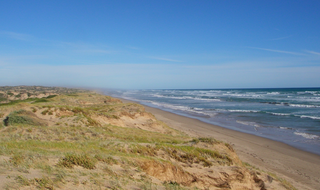
<span class="mw-page-title-main">Torrens Island, South Australia</span> Locality in South Australia

Torrens Island is a locality in the Australian state of South Australia located in the Adelaide metropolitan area within the estuary of the Port River about 16 kilometres north-west of the Adelaide city centre.

Mount Brown Conservation Park is a protected area in the Flinders Ranges of South Australia. The park has established walking trails, including a section of the Heysen Trail. The park is managed by the Department of Environment, Water and Natural Resources; entry is free. It is located 14 km (8.7 mi) south of Quorn and about 300 km (190 mi) north of the nearest airport at Adelaide.

Mud Islands Game Reserve is a protected area in South Australia covering ten islands at the southern side of Lake Alexandrina about 19 kilometres south-east of Goolwa. The game reserve is described as providing ‘an ideal habitat for water birds, particularly waterfowl’ and that ‘duck shooting is permitted during open season.’ Since 2000, the game reserve has been located within the boundaries of the gazetted locality, Coorong.

Loch Luna Reserve is a protected area covering the floodplain on the north side of the River Murray in South Australia between the towns of Kingston-on-Murray in the west and Cobdogla in the east. It is located about 180 kilometres east north-east of the Adelaide city centre. It was proclaimed on 7 November 1985 with exception to a parcel of land known as Sugarloaf Hill within the boundaries of the game reserve which has been excluded from protection for the purpose of mining activity. The Moorook Game Reserve immediately adjoins the game reserve's southern boundary. It and the Moorook Game Reserve are reported as providing "significant wildlife habitat and are popular recreation sites, particularly for river-based activities and camping". The game reserve is classified as an IUCN Category VI protected area. In 1989, it was listed on the now-defunct Register of the National Estate.

<span class="mw-page-title-main">The Dutchmans Stern Conservation Park</span> Protected area in South Australia

The Dutchmans Stern Conservation Park is a protected area located in South Australia about 5 kilometres north-west of the town of Quorn in the Flinders Ranges. It includes a mountain known as The Dutchmans Stern from which its name is derived.

Nilpena Ediacara National Park, which includes the former Ediacara Conservation Park, is a protected area located in the northern Flinders Ranges, in the state of South Australia. It is located about around 551 km (342 mi) north of the city of Adelaide, around 30 kilometres south-west of the town of Leigh Creek in the state's Far North.

Pualco Range Conservation Park is a protected area in the Australian state of South Australia located in the locality of Pualco Range about 30 kilometres south of the town of Yunta in the state's Far North region.

Cooltong Conservation Park is a protected area located in South Australia about 6 kilometres west of the town of Renmark in the Riverland of South Australia. The conservation park was proclaimed under the National Parks and Wildlife Act 1972 in 1993 to "preserve quality mallee vegetation and habitat for the mallee bird species that frequent the area, in particular the Malleefowl." As of 2011, the conservation park was described as being "dominated by mallee vegetation, with undulating dunes and shales" and that it is "popular among birdwatchers eager to catch a glimpse of elusive mallee birds." Services provided within the conservation park as of 2011 include bushwalking, picnic grounds and vehicle tracks only accessible by 4WD vehicles. The conservation park is classified as an IUCN Category VI protected area.

<span class="mw-page-title-main">Dudley Peninsula</span> Place in South Australia

Dudley Peninsula is the peninsula forming the eastern end of Kangaroo Island in the Australian state of South Australia. It was occupied by Aboriginal Australians as recently as 3,100 years BP but was found to be unoccupied by the first European explorers to visit it in the early 19th century. It was first settled by Europeans as early as the 1830s. As of 2011, it had a population of 595 people.

Hardwicke Bay is a bay in the Australian state of South Australia located on the west coast of Yorke Peninsula in Spencer Gulf.

<span class="mw-page-title-main">Inneston, South Australia</span> Suburb of Yorke Peninsula Council, South Australia

Inneston is a locality in the Australian state of South Australia located on the south-western end of Yorke Peninsula about 155 kilometres west of the state capital of Adelaide. Historically, it is notable as a site for the mining of gypsum and since 1970, the majority of the land within the current extent of the locality is within the protected area called the Dhilba Guuranda–Innes National Park.

Media Island Conservation Park is a protected area in the Australian state of South Australia located in the Riverland in the gazetted locality of Loxton about 3 kilometres (1.9 mi) north-east of the Loxton town centre.

Rilli Island Conservation Park is a protected area in the Australian state of South Australia located on the Riverland in the gazetted locality of Loxton North about 6.5 kilometres (4.0 mi) north-east of the Loxton town centre.

Kapunda Island Conservation Park is a protected area in the Australian state of South Australia located on the Riverland in the gazetted locality of Loxton about 1 kilometre (0.62 mi) north-west of the Loxton town centre.

References