
Stickney Island is an uninhabited island of the Sir Joseph Banks Group located in Spencer Gulf, South Australia.
Stickney Island is an uninhabited island of the Sir Joseph Banks Group located in Spencer Gulf, South Australia.
The island was named after Stickney, Lincolnshire (UK). It was named by Captain Matthew Flinders Captain John Franklin during their explorations of the South Australian coast in HMS Investigator.
In the 1800s, Stickney Island was visited by shooters and fishers. [1] In 1885, a lease was offered for grazing and cultivation purposes on Stickney Island. [2] The lease was taken up by J. Sawyer. [3] In 1906, Stickney Island was leased by R. Sawyer, who also leased Roxby Island. [4]
The shipwrecked crew of the cutter Jessie was found there in September 1903, having survived on a diet of fish alone. Their vessel had been inundated during rough seas and sank while the crew was ashore. [5]
In 1939, Zane Grey caught a Great white shark in the waters surrounding Stickney and Spilsby Islands. [6] In the 1930s, fishermen caught sweep and whiting in the waters off Stickney Island. [7]

Port Augusta is a small coastal city in South Australia about 310 kilometres (190 mi) by road from the state capital, Adelaide. Most of the city is on the eastern shores of Spencer Gulf, immediately south of the gulf's head, comprising the city's centre and surrounding suburbs, Stirling North, and seaside homes at Commissariat Point, Blanche Harbor and Miranda. The suburb of Port Augusta West is on the western side of the gulf on the Eyre Peninsula. Together, these localities had a population of 13,515 people in the 2021 census.

The Neptune Islands consist of two groups of islands located close to the entrance to Spencer Gulf in South Australia. They are well known as a venue for great white shark tourism.

The District Council of Lower Eyre Peninsula is a local government area located on Eyre Peninsula in South Australia. The district covers the southern tip of the peninsula, except for the small area taken up by the City of Port Lincoln.
English Island is an island off the coast of Eyre Peninsula in South Australia. It is a part of the Sir Joseph Banks Group and close to Sibsey Island. The island is most notable for its large colony of sea lions, and for a secession movement started by the eccentric and self-styled "Sir Ralph Styles of English Island" in 1954.
Thistle Island / Noondala is in the Spencer Gulf, South Australia, some 200 kilometres (120 mi) west of Adelaide, and northwest of the Gambier Islands. The city of Port Lincoln lies to the northwest of the island. Between them, the Gambier Islands and Thistle form a chain across the mouth of the gulf between the southern tips of the Yorke and Eyre Peninsulas, sometimes referred to as the Taylor Islands group.
Louth Bay is a town and locality in the Australian state of South Australia. It is named after the bay named by Matthew Flinders on 26 February 1802 which itself is derived from a place in Lincolnshire. At the 2006 census, Louth Bay had a population of 408.
The Adelaide Football Club, often referred to as the Old Adelaide Football Club, was an Australian rules football club based in Adelaide. Founded on 26 April 1860, it was the first football club formed in South Australia.

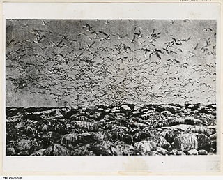
The Sir Joseph Banks Group is an archipelago in the Australian state of South Australia located in Spencer Gulf about 20 kilometres (12 mi) off the eastern coast of the Eyre Peninsula. It consists of 21 islands of which eighteen are in the Sir Joseph Banks Group Conservation Park while the surrounding waters are in the Sir Joseph Banks Group Marine Park. It is considered to be an important seabird breeding site.
Frances was a cutter built in 1839 at Encounter Bay, South Australia. It was wrecked on South Neptune Island on 29 August 1840. It was reported that the crew survived the wrecking event, came ashore and survived on a diet of penguin for 50 days before sending 2 people in a dinghy to Port Lincoln to seek help. Those remaining at South Neptune Island were subsequently rescued. While the wreck site is protected by the Commonwealth Historic Shipwrecks Act 1976 and its location is recorded as being at 35°33′00″S136°12′00″E, as of 2004 it had not been found.
Grantham Island is an uninhabited island occupying 51 hectares of Proper Bay, Spencer Gulf, South Australia. The nearest geographical feature on the mainland is Murray Point, which is also undeveloped. The island was named by explorer Matthew Flinders on 25 February 1802, after the municipal and parliamentary borough of Grantham, Lincolnshire, England. It lies 3 kilometres south of the Port Lincoln marina and is well vegetated.
Boston Island is a 960-hectare (2,400-acre) privately owned island in Boston Bay, Spencer Gulf, South Australia. It has been primarily used for grazing sheep and was also once the location of a proposed township called Kerrillyilla at the southern end of the island. In 2009, the island was rezoned to allow for future residential and tourism development. As of 2009, it is owned by the former mayor of Port Lincoln, Peter Davis. Davis' development plans include up to 1,000 residential allotments, three tourism developments and an inland marina. Prior to rezoning, there had been little interest expressed in the development plan, despite the then mayor's enthusiasm.
Williams Island is an island in the Australian state of South Australia located off the south coast of Jussieu Peninsula on Eyre Peninsula approximately 34 km (21 mi) south-east of Port Lincoln. It was named by Matthew Flinders for Robert Williams who subsequently lost his life along with seven other crew in the capsize of a cutter launched from HM Sloop Investigator to search for water on 21 February 1802. Since 2004, the island has been part of the Memory Cove Wilderness Protection Area.
Smith Island is an island located in Spencer Gulf off the east coast of Jussieu Peninsula on Eyre Peninsula in South Australia approximately 32 km (20 mi) south-east of Port Lincoln. It was named by Matthew Flinders in memory of William Smith who was one of the eight crew lost from a cutter that capsized sometime after being launched from HM Sloop Investigator to search for water on 21 February 1802. Since 2004, the island has been part of the Memory Cove Wilderness Protection Area.
Lewis Island is an island located in Spencer Gulf off the east coast of Jussieu Peninsula on Eyre Peninsula in South Australia approximately 29 km (18 mi) south-east of Port Lincoln. It was named by Matthew Flinders in memory of George Lewis who was one of the eight crew lost from a cutter that capsized sometime after being launched from HM Sloop Investigator to search for water on 21 February 1802. Since 2004, the island has been part of the Memory Cove Wilderness Protection Area.
Hopkins Island is an island located in Spencer Gulf off the east coast of Jussieu Peninsula on Eyre Peninsula in South Australia approximately 32 km (20 mi) south-east of Port Lincoln. It was named by Matthew Flinders in memory of John Hopkins who was one of the eight crew lost from a cutter that capsized on 21 February 1802. Since 2004, the island has been part of the Memory Cove Wilderness Protection Area.
The District Council of Glanville was a local government area in South Australia from 1864 to 1888.
Dangerous Reef is an island and reef system located in the Spencer Gulf in the Australian state of South Australia about 32.5 kilometres (20.2 mi) east-southeast of the city, Port Lincoln. It is the southernmost member of the Sir Joseph Banks Group. It has been the site of a navigation aid since 1911. It is notable as the site of a breeding colony of Australian sea lions. The waters adjoining its shore are notable as a place to view great white sharks to the extent that it was both a popular gamefishing and shark cage diving venue during the twentieth century, and was used to film footage for the following motion pictures – Blue Water White Death and Jaws. The island has enjoyed protected area status since 1900 and it has been part of the Sir Joseph Banks Group Conservation Park since 1989.
Spilsby Island is one of the largest islands in the Sir Joseph Banks Group in Spencer Gulf, South Australia. It is privately owned, has no permanent human residents and is grazed by sheep. The island was used for the breeding of sheep by James Hunter Kerrison, then for the breeding of horses, sheep, pigs and cattle by W. E. Scruby in the early 20th century. Shearers travelled to the island to shear the sheep. The island's soil has been enriched by the deposition of guano by seabirds. Land allotments and a few shacks are concentrated along the northern coast of the island. Butterfish Bay is on the northern coast and Hawknest Bay is on the eastern coast.
Boucaut Island is a small, uninhabited island in the Sir Joseph Banks Group in South Australia's Spencer Gulf. It lies 1.2 km northeast of Spilsby Island. Seal Rock lies 250 metres southeast of Boucaut Island.
Langton Island is a small, uninhabited island of the Sir Joseph Banks Group in Spencer Gulf, South Australia. The Island was named by Captain Matthew Flinders during his exploration of South Australia's coastline in 1802. Langton Island was named after Langton Hall in Lincolnshire. A "huge" breeding colony of Fairy terns was found on Langton Island by naturalists from the McCoy Society in 1937. Fishermen have caught whiting in nearby waters.
34°40′41″S136°16′14″E / 34.67806°S 136.27056°E
| | This South Australia article is a stub. You can help Wikipedia by expanding it. |