
The Spencer Gulf is the westernmost and larger of two large inlets on the southern coast of Australia, in the state of South Australia, facing the Great Australian Bight. It spans from the Cape Catastrophe and Eyre Peninsula in the west to Cape Spencer and Yorke Peninsula in the east.
English Island is an island off the coast of Eyre Peninsula in South Australia. It is a part of the Sir Joseph Banks Group and close to Sibsey Island. The island is most notable for its large colony of sea lions, and for a secession movement started by the eccentric and self-styled "Sir Ralph Styles of English Island" in 1954.
Flinders Island is an island in the Investigator Group off the coast of South Australia approximately 32 kilometres (20 mi) west of mainland town Elliston. It was named by Matthew Flinders after his younger brother Samuel Flinders, the second lieutenant on HMS Investigator in 1802.
The Investigator Group is an archipelago in South Australia that consists of Flinders Island and five island groups located off the western coast of the Eyre Peninsula. It is named after HMS Investigator by her commander, Matthew Flinders when he explored the area in 1802. The Group lies within the Great Australian Bight. All the islands except Flinders Island, and a part of Pearson Island, are within the Investigator Group Wilderness Protection Area and the Waldegrave Islands Conservation Park.

The Sir Joseph Banks Group is an archipelago in the Australian state of South Australia located in Spencer Gulf about 20 kilometres (12 mi) off the eastern coast of the Eyre Peninsula. It consists of 21 islands of which eighteen are in the Sir Joseph Banks Group Conservation Park while the surrounding waters are in the Sir Joseph Banks Group Marine Park. It is considered to be an important seabird breeding site.

Troubridge Island is an island located in the south west corner of Gulf St Vincent in South Australia near the eastern edge of the Troubridge Shoals off the east coast of Yorke Peninsula about 8 kilometres (5.0 mi) southeast by east of the town of Edithburgh It is notable for being a site of an operating lighthouse from 1856 until 2002 and as a site for a sea bird rookery. Since 1982, the island has been part of the Troubridge Island Conservation Park.

The Pages is an island group in the Australian state of South Australia consisting of two small islands and a reef located in Backstairs Passage, a strait separating Kangaroo Island and the Fleurieu Peninsula. The island group has been located with the protected area known as The Pages Conservation Park since 1972.
The Althorpe Islands are a group of islands in the Investigator Strait, off the south-western tip of Yorke Peninsula, South Australia. The group includes Althorpe Island and two rocky islets immediately to its west known as The Boobs. These are located 7.7 km south-southwest of Cape Spencer on the mainland. Closer inshore are Seal Island and Haystack Island, which together with Althorpe Island and The Boobs constitute the Althorpe Islands Conservation Park. A management plan for the Althorpe Islands Conservation Park was adopted in 2009. The islands are uninhabited and can only be accessed by sea or by helicopter.

Greenly Island is an island in the Australian state of South Australia located in the Great Australian Bight about 30 kilometres (19 mi) west-south-west of Point Whidbey on Eyre Peninsula. The island is uninhabited by humans and provides a haven for marine and terrestrial wildlife. The island and its intertidal zone constitute the Greenly Island Conservation Park. Its adjacent waters are occasionally visited by fishermen targeting yellowtail kingfish.
Williams Island is an island in the Australian state of South Australia located off the south coast of Jussieu Peninsula on Eyre Peninsula approximately 34 km (21 mi) south-east of Port Lincoln. It was named by Matthew Flinders for Robert Williams who subsequently lost his life along with seven other crew in the capsize of a cutter launched from HM Sloop Investigator to search for water on 21 February 1802. Since 2004, the island has been part of the Memory Cove Wilderness Protection Area.
Smith Island is an island located in Spencer Gulf off the east coast of Jussieu Peninsula on Eyre Peninsula in South Australia approximately 32 km (20 mi) south-east of Port Lincoln. It was named by Matthew Flinders in memory of William Smith who was one of the eight crew lost from a cutter that capsized sometime after being launched from HM Sloop Investigator to search for water on 21 February 1802. Since 2004, the island has been part of the Memory Cove Wilderness Protection Area.
Lewis Island is an island located in Spencer Gulf off the east coast of Jussieu Peninsula on Eyre Peninsula in South Australia approximately 29 km (18 mi) south-east of Port Lincoln. It was named by Matthew Flinders in memory of George Lewis who was one of the eight crew lost from a cutter that capsized sometime after being launched from HM Sloop Investigator to search for water on 21 February 1802. Since 2004, the island has been part of the Memory Cove Wilderness Protection Area.
Hopkins Island is an island located in Spencer Gulf off the east coast of Jussieu Peninsula on Eyre Peninsula in South Australia approximately 32 km (20 mi) south-east of Port Lincoln. It was named by Matthew Flinders in memory of John Hopkins who was one of the eight crew lost from a cutter that capsized on 21 February 1802. Since 2004, the island has been part of the Memory Cove Wilderness Protection Area.

Anxious Bay is a bay in the Australian state of South Australia located on the west coast of Eyre Peninsula about 275 kilometres west north-west of Adelaide. It was named by Matthew Flinders on 21 February 1802. It is one of four ‘historic bays’ located on the South Australian coast.
Ward Islands is an island group in the Australian state of South Australia located in the Investigator Group about 53 kilometres west by south of Cape Finniss on the west coast of Eyre Peninsula. The group was discovered and named by Matthew Flinders on 13 February 1802. The island group has enjoyed protected area status since the 1960s and since 2011, it been part of the Investigator Group Wilderness Protection Area.
Topgallant Islands is an island group in the Australian state of South Australia located in the Investigator Group about 22 kilometres south west of Cape Finniss on the west coast of Eyre Peninsula. The group was discovered and named by Matthew Flinders on 13 February 1802. The island group has enjoyed protected area status since the 1960s and since 2011, it has been part of the Investigator Group Wilderness Protection Area.

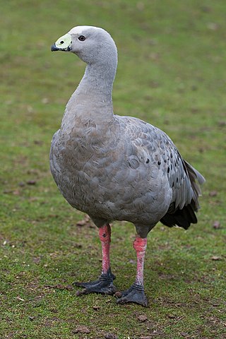
Waldegrave Islands is an island group in the Australian state of South Australia located in the Investigator Group about 2.5 kilometres northwest by west of Cape Finniss on the west coast of Eyre Peninsula. The group consists of Waldegrave Island, Little Waldegrave Island and according to some sources, a pair of rocks known as the Watchers. The group is notable as a breeding site for Australian sea lions and Cape Barren geese. The group has enjoyed protected area status since the 1960s and as of 1972 has been part of the Waldegrave Islands Conservation Park.
Dorothee Island is an island in the Australian state of South Australia which is part of the Pearson Isles which itself is part of the larger island grouping known as the Investigator Group. It is located about 69 kilometres west south-west of Cape Finniss on the west coast of Eyre Peninsula. It was discovered as part of the Pearson Isles by Matthew Flinders on 13 February 1802. The island was given its name in August 1969 in order to preserve a name used within the locality by the Baudin expedition. The island has enjoyed protected area status since at least 1972 and since 2011, it been part of the Investigator Group Wilderness Protection Area.
Veteran Isles is a pair of islands in the Australian state of South Australia which is part of the Pearson Isles which itself is part of the larger island group known as the Investigator Group. It is located about 69 kilometres west south-west of Cape Finniss on the west coast of Eyre Peninsula. It was discovered as part of the Pearson Isles by Matthew Flinders on 13 February 1802. The island was given its name in August 1969 in order to preserve a name used within the locality by the Baudin expedition. The island has enjoyed protected area status since at least 1972 and since 2011, it been part of the Investigator Group Wilderness Protection Area.

Pearson Island is an island located in the Australian state of South Australia within the Pearson Isles an island group located in the larger group known as the Investigator Group about 63 kilometres southwest by west of Cape Finniss on the west coast of Eyre Peninsula. The group was discovered and named by Matthew Flinders on 13 February 1802. The island group has enjoyed protected area status since the 1960s and since 2011, it has been part of the Investigator Group Wilderness Protection Area. Pearson Island is notable both for its colony of Pearson Island Rock wallaby and for being a destination for scientific research.
