Chinamans Hat Island

Last updated

Chinamans Hat Island
Chinamans Hat Island.JPG
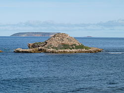
Chinamans Hat Island as viewed from the nearby coastline
Australia South Australia location map.svg
Red pog.svg
Chinamans Hat Island
Geography
Location Investigator Strait
Coordinates 35°17′20″S136°55′05″E / 35.28876°S 136.91795°E / -35.28876; 136.91795 Coordinates: 35°17′20″S136°55′05″E / 35.28876°S 136.91795°E / -35.28876; 136.91795
Administration
Australia

Chinamans Hat Island is an islet located off the south coast of Yorke Peninsula in Investigator Strait in South Australia about 2.4 kilometres (1.5 miles) south-west of Stenhouse Bay and within 350 metres (1,150 feet) of the shore. As of 2014, it is located within the Innes National Park.

Contents

Description

Chinamans Hat Island is located about 350 metres (1,150 feet) from the shoreline and about 2.4 kilometres (1.5 miles) south-west of Stenhouse Bay. The islet is a remnant piece of cliff line which rises to a height of 11 metres (36 feet) and sits on an intertidal rock platform that joins the mainland at the west and extends past the island to the east. The islet is named due to the similarity of its shape to a conical Asian hat. Access is reported as being ‘best gained by small boat, taking care to avoid the shallow rocks and reefs in the surrounding waters.’ [1] The name ‘Chinamans Hat’ is also informally used for other features near the islet such as the small bay located between it and the mainland, the intertidal reef that connects it to the mainland and facilities on the mainland provided as part of the Innes National Park. [2]

Formation, geology and oceanography

Chinamans Hat Island was formed between 7500 and 8900 years ago after sea levels rose at the start of the Holocene thereby separating Yorke Peninsula from Kangaroo Island. [3] Chinamans Hat Island is reported as being entirely composed of a Bridgewater Formation calcarenite rock with ‘distinct horizontal layers of hard calcrete’. [1] [4] The islet rises from a depth of 10 metres (33 feet). [5]

Flora and fauna

Flora

A survey conducted in 1996 found eleven species of plants including sea celery, marsh saltbush, round leaved pigface, ruby saltbush, grey samphire, nitre-bush, bower spinach and common iceplant. [1]

Fauna

As of 1996, vertebrate animals were represented by bird species such as little penguins, feral pigeons and sooty oystercatchers. [1]

Protected areas status

Chinamans Hat Island has been reported as being part of the Innes National Park by 1980. [6] Since 2012, the waters surrounding its shores are located in a sanctuary zone within the boundaries of the South Spencer Gulf Marine Park. [7]

Related Research Articles

Dhilba Guuranda-Innes National Park Protected area in the Yorke Peninsula, South Australia

Dhilba Guuranda-Innes National Park, formerly Innes National Park, is an IUCN-designated protected area in the Australian state of South Australia located on the southwest tip of Yorke Peninsula about 300 kilometres (190 mi) west of the state capital of Adelaide. It is a popular destination for camping, bushwalking, fishing, surfing and scuba diving.

Investigator Strait Body of water in South Australia lying between the Yorke Peninsula, on the Australian mainland, and Kangaroo Island

Investigator Strait is a body of water in South Australia lying between the Yorke Peninsula, on the Australian mainland, and Kangaroo Island. It was named by Matthew Flinders after his ship, HMS Investigator, on his voyage of 1801–1802. It is bordered by the Gulf St Vincent in the northeast.

Cape Spencer (South Australia) South Australia

Cape Spencer is a headland in the Australian state of South Australia located on the south west tip of Yorke Peninsula in the gazetted locality of Inneston. It was named after George Spencer, 2nd Earl Spencer by Matthew Flinders during March 1802. It has been the site of an operating navigation aid since 1950 and has been located within the Innes National Park since 1970.

Nuyts Archipelago

The Nuyts Archipelago is an island group located in South Australia in the Great Australian Bight to the south of the town of Ceduna on the west coast of the Eyre Peninsula. It consisting of mostly granitic islands and reefs that provide breeding sites for Australian sea lions and support colonies of short-tailed shearwater. It also includes the island group known as the Isles of St Francis. All the islands with exception of a part of Evans Island, are located with the following protected areas - the Nuyts Archipelago Wilderness Protection Area and the Nuyts Archipelago Conservation Park.

Troubridge Island

Troubridge Island is an island located in the south west corner of Gulf St Vincent in South Australia near the eastern edge of the Troubridge Shoals off the east coast of Yorke Peninsula about 8 kilometres (5.0 mi) southeast by east of the town of Edithburgh It is notable for being a site of an operating lighthouse from 1856 until 2002 and as a site for a sea bird rookery. Since 1982, the island has been part of the Troubridge Island Conservation Park.

Cape Gantheaume South Australia

Cape Gantheaume is a headland located on the south coast of Kangaroo Island in South Australia. It was named after Vice admiral Honoré Joseph Antoine Ganteaume (1755–1818) by the Baudin expedition to Australia during 1803. It is currently located within the protected area known as the Cape Gantheaume Wilderness Protection Area.

Pelorus Islet

Pelorus Islet is an islet in the Australian state of South Australia located in Great Australian Bight off the south coast of Kangaroo Island approximately 7 kilometres east south-east of Cape Gantheaume. It was named by Captain Francis Harding, RN after HMS Pelorus.

Nobby Islet Island in South Australia

Nobby Islet is an islet located in the Great Australian Bight off the south coast of Kangaroo Island in the Australian state of South Australia approximately 50 kilometres south-west of Kingscote. It is currently part of the Seal Bay Conservation Park.

Paisley Islet Island in South Australia

Paisley Islet is an islet located in the Great Australian Bight immediately off the west coast of Kangaroo Island in South Australia approximately 104 kilometres west south-west of Kingscote. It is currently part of the Flinders Chase National Park.

Casuarina Islets

The Casuarina Islets, also known as The Brothers, is a pair of islands located in the Great Australian Bight immediately off the south-west coast of Kangaroo Island in South Australia approximately 96 kilometres south-west of Kingscote. The pair is currently part of the Flinders Chase National Park.

Seal Island (Investigator Strait) Island in South Australia

Seal Island is an island located in Investigator Strait off the south coast of Yorke Peninsula in the Australian state of South Australia about 7 kilometres south south-west of Stenhouse Bay. Since 1972, it has been part of the Althorpe Islands Conservation Park.

Haystack Island Island in South Australia

Haystack Island is an island located in Investigator Strait off the south coast of Yorke Peninsula in the Australian state of South Australia about 6 kilometres south-west of Stenhouse Bay. Since 1972, it has been part of the Althorpe Islands Conservation Park.

Point Labatt South Australia

Point Labatt is a headland located on the west coast of Eyre Peninsula in the Australian state of South Australia about 39 kilometres south by east of Streaky Bay. It is notable as one of the largest Australian mainland breeding sites for Australian sea lions. The land and the sea adjoining Point Labatt is part of three protected areas - the Point Labatt Conservation Park, the Point Labatt Aquatic Reserve and the West Coast Bays Marine Park.

Pondalowie Bay

Pondalowie Bay is a bay in the Australian state of South Australia located on the west coast of the south-west tip of Yorke Peninsula in Spencer Gulf about 12 kilometres west of Marion Bay. The coastline of Pondalowie Bay is both within the gazetted locality of Inneston and the Innes National Park.

Ward Islands (South Australia) Islands in South Australia

Ward Islands is an island group in the Australian state of South Australia located in the Investigator Group about 53 kilometres west by south of Cape Finniss on the west coast of Eyre Peninsula. The group was discovered and named by Matthew Flinders on 13 February 1802. The island group has enjoyed protected area status since the 1960s and since 2011, it been part of the Investigator Group Wilderness Protection Area.

Western Kangaroo Island Marine Park Marine protected area south-west of Kangaroo Island in Australia

Western Kangaroo Island Marine Park is a marine protected area located south of South Australia in waters within the Australian Exclusive economic zone to the south-west of Kangaroo Island and ranging in depth from 15 metres to 165 metres.

Royston Island Island in South Australia

Royston Island is an island in the Australian state of South Australia at the northern end of Pondalowie Bay on the south-west extremity of Yorke Peninsula about 13 kilometres north-west of the town of Stenhouse Bay. The island has enjoyed protected area status since 1967 and since 1972, it has been part of the Innes National Park.

South Island (South Australia) Island in South Australia

South Island is an island located in the Australian state of South Australia at the south end of Pondalowie Bay on the south-west extremity of Yorke Peninsula about 11 kilometres north-west by west of the town of Stenhouse Bay. The island has enjoyed protected area status since 1970 and since 1977, it has been part of the Innes National Park.

Inneston, South Australia South Australia

Inneston is a locality in the Australian state of South Australia located on the south-western end of Yorke Peninsula about 155 kilometres west of the state capital of Adelaide. Historically, it is notable as a site for the mining of gypsum and since 1970, the majority of the land within the current extent of the locality is within the protected area called the Innes National Park.

Western Kangaroo Island Marine Park (state waters) Protected area in South Australia

Western Kangaroo Island Marine Park is a marine protected area in the Australian state of South Australia located in the state’s coastal waters adjoining both the west coast of Kangaroo Island and Lipson Reef, an islet located to the south of Kangaroo Island.

References

  1. 1 2 3 4 A. C. Robinson; P. Canty; T. Mooney; P. Rudduck (1996). "South Australia's offshore islands" (PDF). Australian Heritage Commission. pp. 285–286. Retrieved 13 December 2013.
  2. "Innes National Park Management Plan" (PDF). Department of Environment, Water and Natural Resources. pp. 10, 14, 39 & 41. Retrieved 2 July 2014.
  3. Robinson, A. C.; Armstrong, D. M., eds. (1999). A Biological Survey of Kangaroo Island, South Australia, 1989 & 1990 (PDF). Adelaide, SA: Heritage and Biodiversity Section, Department for Environment, Heritage and Aboriginal Affairs, South Australia. p. 26. ISBN   0-7308-5862-6 . Retrieved 1 May 2014.
  4. Fairclough, Martin C (December 2007). "KINGSCOTE Special 1:250 000 geological map". MESA Journal. Government of South Australia, DMITRE. 47: 28–31. ISSN   1326-3544 . Retrieved 18 May 2014.
  5. South Australia. Department of Marine and Harbors (1985), The Waters of South Australia a series of charts, sailing notes and coastal photographs, Dept. of Marine and Harbors, South Australia, pp. Chart 23, ISBN   978-0-7243-7603-2
  6. "Innes National Park Management Plan" (PDF). Department of Environment, Water and Natural Resources. p. 10. Retrieved 2 July 2014.
  7. "Marine Park 12, South Spencer Gulf" (PDF). Department of Environment Water and Natural Resources. 2012. Retrieved 2 July 2014.