Wallaroo is a port town on the western side of Yorke Peninsula in South Australia, 160 kilometres (100 mi) northwest of Adelaide. It is one of the three Copper Triangle towns famed for their historic shared copper mining industry, and known together as "Little Cornwall", the other two being Kadina, about 8 kilometres (5 mi) to the east, and Moonta, about 18 kilometres (11 mi) south. In 2016, Wallaroo had a population of 3,988 according to the census held.

Thevenard is a port town in the far west of Eyre Peninsula, South Australia. It is contiguous with the larger town of Ceduna. Its name derives from nearby Cape Thevenard, which in turn was named after Antoine-Jean-Marie Thévenard, a French admiral. In the 2021 census, Thevenard had a population of 563.

Port Broughton is a small South Australian town located at the northern extent of the Yorke Peninsula on the east coast of Spencer Gulf. It is situated about 170 km north-west of Adelaide, and 56 km south of Port Pirie. At the 2016 census, the town of Port Broughton had a population of 1,034.

The Barunga West Council is a local government area in the Yorke and Mid North region of South Australia. The council seat is at Port Broughton, with a sub-office at Bute.

Passat is a German four-masted steel barque and one of the Flying P-Liners, the famous sailing ships of the German shipping company F. Laeisz. She is one of the last surviving windjammers.

Ardrossan is a town in the Australian state of South Australia located on the eastern coast of the Yorke Peninsula, about 150 kilometres (93 mi) by road from the Adelaide city centre. It is notable for its deepwater shipping port and its towering coastal cliffs of red clay.

Edithburgh is a small town on the south-east corner of Yorke Peninsula situated on the coastline of Salt Creek Bay, in the state of South Australia. Edithburgh is about 50 km (31 mi) west of Adelaide across Gulf St Vincent, but 226 km (140 mi) away by road.
Port Victoria is a town on the west coast of Yorke Peninsula in the Australian state of South Australia.

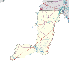
The Yorke Peninsula Council is a local government area in South Australia. Its boundaries include most of the Yorke Peninsula. The council seat is at Maitland; the council also maintains branch offices at Minlaton and Yorketown.

Tumby Bay is a coastal town situated on the Spencer Gulf, on the eastern coast of Eyre Peninsula in South Australia, 45 kilometres (28 mi) north of Port Lincoln. The town of Tumby Bay is the major population centre of the District Council of Tumby Bay, and the centre of an agricultural district farming cereal crops and sheep, as well as having established fishing and tourism industries.

Port Vincent is a small town on the east coast of Yorke Peninsula in South Australia, 194 km from Adelaide by road.
Port Hughes is a town and locality in the Australian state of South Australia located on northern Yorke Peninsula about 135 kilometres (84 mi) north-west of the state capital of Adelaide. It is considered part of the Moonta urban area by the Australian Bureau of Statistics. At the 2016 census, Port Hughes had a population of 571.

Wool Bay is a locality and a former government town in the Australian state of South Australia on the east coast of southern Yorke Peninsula. It is located between Stansbury and Coobowie on Yorke Peninsula, approximately 220 kilometres from Adelaide by road, but only just over 60 km due west across Gulf St Vincent.

Maitland is a town in South Australia known as the "heart of Yorke Peninsula" due to it being near the centre of the region. By road, it is 168 km west of Adelaide, 164 km south of Port Pirie and 46 km north of Minlaton.

Copper Coast is a region of South Australia situated in Northern Yorke Peninsula and comprising the towns of Wallaroo, Kadina, Moonta, Paskeville and Port Hughes. The area approximately bounded by Wallaroo, Kadina and Moonta is also known as the Copper Triangle. The area is so named because copper was mined from there in the late 19th and early 20th centuries, a significant source of economic prosperity for South Australia at the time. These three towns are known for their large Cornish ethnicity, often called "Little Cornwall". Kernewek Lowender is the world's largest Cornish Festival, held biennially in the Cornish Triangle. The area continues to make a significant contribution to the economy of South Australia, as a major producer of grain, particularly barley and wheat.

Clinton is a locality in the Australian state of South Australia located on the east coast of Yorke Peninsula overlooking the north west head of Gulf St Vincent about 101 kilometres (63 mi) west of the state capital of Adelaide and about 36 kilometres (22 mi) north-east of the municipal seat of Maitland.

Grain Race or The Great Grain Race was the informal name for the annual windjammer sailing season generally from South Australia's grain ports on Spencer Gulf to Lizard Point, Cornwall on the southwesternmost coast of the United Kingdom, or to specific ports. A good, fast passage Australia-to-England via Cape Horn was considered anything under 100 days.
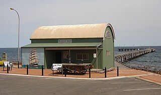
The Port Victoria Maritime Museum is a maritime museum located in South Australia, located on the west coast of the Yorke Peninsula in Port Victoria. It is housed in a cargo shed which was brought out from the United Kingdom in kit form in 1877 and was completed in January 1878. Household goods for the early settlers in the town and surrounding farmlands were brought by steamers from Port Adelaide and stored in the cargo shed until the settlers’ homes were completed.

Port Arthur is a locality in the Australian state of South Australia located on the Yorke Peninsula at the northern end of Gulf St Vincent about 105 kilometres north west of the state capital of Adelaide and about 9 kilometres north of the town of Port Wakefield.
Hardwicke Bay is a bay in the Australian state of South Australia located on the west coast of Yorke Peninsula in Spencer Gulf.