
Dhilba Guuranda-Innes National Park, formerly Innes National Park, is an IUCN-designated protected area in the Australian state of South Australia located on the southwest tip of Yorke Peninsula about 300 kilometres (190 mi) west of the state capital of Adelaide. It is a popular destination for camping, bushwalking, fishing, surfing and scuba diving.

The Spencer Gulf is the westernmost and larger of two large inlets on the southern coast of Australia, in the state of South Australia, facing the Great Australian Bight. It spans from the Cape Catastrophe and Eyre Peninsula in the west to Cape Spencer and Yorke Peninsula in the east.

Investigator Strait is a body of water in South Australia lying between the Yorke Peninsula, on the Australian mainland, and Kangaroo Island. It was named by Matthew Flinders after his ship, HMS Investigator, on his voyage of 1801–1802. It is bordered by the Gulf St Vincent in the northeast.

Cape Borda is a headland in the Australian state of South Australia located in the gazetted locality of Cape Borda on the north west tip of Kangaroo Island about 70 km (43 mi) west of the municipal seat of Kingscote. It was named after Jean-Charles de Borda (1733–1799), the French mathematician, physicist, naturalist and sailor, by the Baudin expedition to Australia during January 1803. It has been the site of an operating lighthouse since 1858 and is currently located within the Flinders Chase National Park.

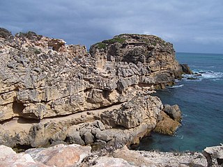
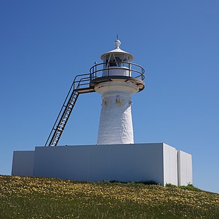
Cape Spencer is a headland in the Australian state of South Australia located on the south west tip of Yorke Peninsula in the gazetted locality of Inneston. It was named after George Spencer, 2nd Earl Spencer by Matthew Flinders during March 1802. It has been the site of an operating navigation aid since 1950 and has been located within the Innes National Park since 1970.

Troubridge Point is a headland in the Australian state of South Australia located on the south coast of Yorke Peninsula about 11 kilometres south west of Edithburgh. It is the western end of the opening to Gulf St Vincent.

Chinamans Hat Island is an islet located off the south coast of Yorke Peninsula in Investigator Strait in South Australia about 2.4 kilometres south-west of Stenhouse Bay and within 350 metres of the shore. As of 2014, it is located within the Innes National Park.
Sultana Point is a headland in the Australian state of South Australia located near the south east tip of Yorke Peninsula in the gazetted locality of Sultana Point about 3.3 kilometres south-southeast of the town of Edithburgh. The waters to its immediate east contain the shoal system known as the Troubridge Shoals. It is one of the natural features named after the Sultana, a ship which was wrecked on the Troubridge Shoals on 28 September 1849. The waters adjoining its shores are located within the boundaries of the Lower Yorke Peninsula Marine Park.

Pondalowie Bay is a bay in the Australian state of South Australia located on the west coast of the south-west tip of Yorke Peninsula in Spencer Gulf about 12 kilometres west of Marion Bay. The coastline of Pondalowie Bay is both within the gazetted locality of Inneston and the Innes National Park.

Tiparra Reef is a reef located in Spencer Gulf in South Australia about 14 kilometres west of the town of Port Hughes.
Cape Northumberland is a headland in the southeast of the Australian state of South Australia. It is the southernmost point of South Australia. It is located about 3 kilometres (1.9 mi) from the town of Port MacDonnell, 28 kilometres south southwest from the municipal seat of Mount Gambier and about 393 kilometres (244 mi) southeast of the state's capital Adelaide.

Corny Point is a headland located on the west coast of the Yorke Peninsula in South Australia about 37 kilometres north west of the town of Warooka. The point is described as being "a sloping rocky double projection..." where the "coast on the N[orth] side is low and sandy whereas the coast on the S[outh] side is higher than the point itself." It is the south headland of Hardwicke Bay. It was named by Matthew Flinders on 18 March 1802. The waters adjoining its shoreline are within the Southern Spencer Gulf Marine Park. Since 1882, it has been the site of a navigation aid in the form of a lighthouse.

Cape Willoughby is a headland in the Australian state of South Australia located on the east end of the Dudley Peninsula on Kangaroo Island in the gazetted locality of Willoughby about 22 kilometres south east of the town of Penneshaw.
Cape St Albans is a headland in the Australian state of South Australia located on the north coast of the Dudley Peninsula on Kangaroo Island in the gazetted locality of Willoughby about 18 kilometres south-east of the town of Penneshaw.
Royston Island is an island in the Australian state of South Australia at the northern end of Pondalowie Bay on the south-west extremity of Yorke Peninsula about 13 kilometres north-west of the town of Stenhouse Bay. The island has enjoyed protected area status since 1967 and since 1972, it has been part of the Innes National Park.

South Island is an island located in the Australian state of South Australia at the south end of Pondalowie Bay on the south-west extremity of Yorke Peninsula about 11 kilometres north-west by west of the town of Stenhouse Bay. The island has enjoyed protected area status since 1970 and since 1977, it has been part of the Innes National Park.

Hardwicke Bay is a bay in the Australian state of South Australia located on the west coast of Yorke Peninsula in Spencer Gulf.
Inneston is a locality in the Australian state of South Australia located on the south-western end of Yorke Peninsula about 155 kilometres west of the state capital of Adelaide. Historically, it is notable as a site for the mining of gypsum and since 1970, the majority of the land within the current extent of the locality is within the protected area called the Innes National Park.
Nalyappa is a locality in the Australian state of South Australia located on the west coast of Yorke Peninsula immediately adjoining Spencer Gulf about 128 kilometres north-west of the state capital of Adelaide.

Sleaford Bay is a bay located in the Australian state of South Australia on the southern coast of Eyre Peninsula. It was named by the British navigator, Matthew Flinders in 1802.
