Wool Bay, South Australia

Last updated

Wool Bay
South Australia
Wool bay.jpg
View of Wool Bay and jetty from the cliff top
Australia South Australia location map.svg
Red pog.svg
Wool Bay
Coordinates 34°59′35″S137°45′15″E / 34.993186°S 137.754235°E / -34.993186; 137.754235 [1]
Population138 (2016 census) [2]
Established24 August 1876 (town)
27 May 1999 (locality) [3] [4]
Postcode(s) 5575 [5]
Time zone ACST (UTC+9:30)
 • Summer (DST) ACST (UTC+10:30)
Location
LGA(s) Yorke Peninsula Council [1]
Region Yorke and Mid North [1]
County Fergusson [1]
State electorate(s) Narungga [6]
Federal division(s) Grey [7]
Mean max temp [8] Mean min temp [8] Annual rainfall [8]
20.5 °C
69 °F
12.1 °C
54 °F
377.6 mm
14.9 in
Localities around Wool Bay:
Yorketown Stansbury
Yorketown Wool Bay Gulf St Vincent
Yorketown Coobowie
FootnotesAdjoining localities [1]

Wool Bay (formerly Pickering) is a locality and a former government town in the Australian state of South Australia on the east coast of southern Yorke Peninsula. It is located between Stansbury and Coobowie on Yorke Peninsula, approximately 220 kilometres from Adelaide by road, but only just over 60 km due west across Gulf St Vincent.

Contents

Description

The beach of Wool Bay features a permanently moored pontoon which is maintained by the local progress association, several sun shelters and a concrete boat ramp. [9] A number of marine animals inhabit the waters of Wool Bay; dolphins and sting rays can frequently be seen close to shore, and fur seals often feed off the rocky outcrop between the second and third coves past the main bay in the early evening.

History

The town was originally called Pickering when it was established on 24 August 1876. [3] It is on cliffs overlooking a protected bay. In 1882 a jetty was built, initially to roll wool bales out to the ships. The locals named the jetty as Wool Bay jetty and by 1940, the name of the town had also changed to Wool Bay. [10] For many years, the town functioned as a wool, grain and lime exporting port.

History of lime burning at Wool Bay

Wool Bay lime kiln Wool Bay Lime kiln.jpg
Wool Bay lime kiln

Between 1900 and 1910, six lime kilns were built on the cliffs overlooking the bay. Lime was burnt to create quicklime, an ingredient in mortar and brick-making. The kilns were one of the largest and most modern facilities in the state when they were established by David Miller & Sons, and opened in 1910. [11] The Wool Bay lime kilns closed in the 1960s and most of the kilns and associated infrastructure were demolished in the 1970s. [12] One kiln remains and was listed along with the jetty under the name of Wool Bay Lime Kiln & Jetty on the South Australian Heritage Register on 28 November 1985. [13] Limestone is still mined at Klein Point north of the township of Wool Bay, and shipped from a separate jetty to the Adelaide Brighton Cement facility near Port Adelaide.

Wool Bay jetty

Community lobbying for a jetty commenced in 1879: the people believed that deep water in the bay would provide safer anchorage than other nearby locations. Eventually in 1882 construction of a jetty was undertaken by Frank George. Originally 155 metres long, it provided a depth of 2.1 metres at low tide. When lime burning became an established industry at Wool Bay the jetty was extended by a further 18 metres in anticipation of increased use. During this time, a steamship service dropped off and picked up provisions three times a week. When bulk-handling of grain was introduced at Port Giles in 1970, Wool Bay's importance as a port declined.

Today, the jetty at Wool Bay is popular with anglers. It is known for producing good catches[ according to whom? ] of squid and tommy ruff throughout the year while garfish, mullet, snook and other species can be caught in season. The jetty is also used by recreational scuba divers, drawn by the population of leafy seadragon that inhabit the waters beneath the jetty.

Governance

Wool Bay is located in the federal Division of Grey, the state electoral district of Narungga and the local government area of Yorke Peninsula Council. [7] [6] [1]

See also

Related Research Articles

<span class="mw-page-title-main">Wallaroo, South Australia</span> Town in South Australia

Wallaroo is a port town on the western side of Yorke Peninsula in South Australia, 160 kilometres (100 mi) northwest of Adelaide. It is one of the three Copper Triangle towns famed for their historic shared copper mining industry, and known together as "Little Cornwall", the other two being Kadina, about 8 kilometres (5 mi) to the east, and Moonta, about 18 kilometres (11 mi) south. In 2016, Wallaroo had a population of 3,988 according to the census held.

<span class="mw-page-title-main">Port Broughton, South Australia</span> Town in South Australia

Port Broughton is a small South Australian town located at the northern extent of the Yorke Peninsula on the east coast of Spencer Gulf. It is situated about 170 km north-west of Adelaide, and 56 km south of Port Pirie. At the 2011 census, the town of Port Broughton had a population of 1,034.

<span class="mw-page-title-main">Ardrossan, South Australia</span> Town in South Australia

Ardrossan is a town in the Australian state of South Australia located on the eastern coast of the Yorke Peninsula, about 150 kilometres (93 mi) by road from the Adelaide city centre. It is notable for its deepwater shipping port and its towering coastal cliffs of red clay.

<span class="mw-page-title-main">Edithburgh</span> Coastal town in South Australia

Edithburgh is a small town on the south-east corner of Yorke Peninsula situated on the coastline of Salt Creek Bay, in the state of South Australia. Edithburgh is about 50 km (31 mi) west of Adelaide across Gulf St Vincent, but 226 km (140 mi) away by road. At the 2016 census, the locality had a population of 516 of which 454 lived in its town centre.

<span class="mw-page-title-main">Port Vincent, South Australia</span> Town in South Australia

Port Vincent is a small town on the east coast of Yorke Peninsula in South Australia, 194 km from Adelaide by road. At the 2016 census, Port Vincent had a population of 514.

<span class="mw-page-title-main">Moonta, South Australia</span> Town in South Australia

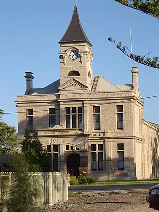
Moonta is a town on the Yorke Peninsula of South Australia, 165 km (103 mi) north-northwest of the state capital of Adelaide. It is one of three towns known as the Copper Coast or "Little Cornwall" for their shared copper mining history.

<span class="mw-page-title-main">Marion Bay, South Australia</span> Town in South Australia

Marion Bay is a small township in the Australian state of South Australia at the southern tip of the Yorke Peninsula. At the 2016 census, Marion Bay had a population of 172. Historically, it formed part of Narungga lands.

<span class="mw-page-title-main">Port Hughes, South Australia</span> Coastal town in South Australia

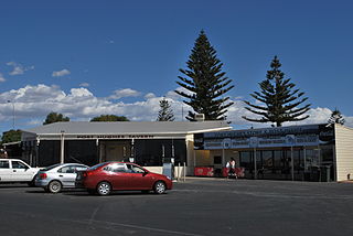
Port Hughes is a town and locality in the Australian state of South Australia located on northern Yorke Peninsula about 135 kilometres (84 mi) north-west of the state capital of Adelaide. It is considered part of the Moonta urban area by the Australian Bureau of Statistics. At the 2016 census, Port Hughes had a population of 571.

<span class="mw-page-title-main">Moonta Bay, South Australia</span> Town in South Australia

Moonta Bay is located in the Copper Coast region of Northern Yorke Peninsula South Australia, adjacent to the historic town of Moonta and Port Hughes.

<span class="mw-page-title-main">Stansbury, South Australia</span> Town in South Australia

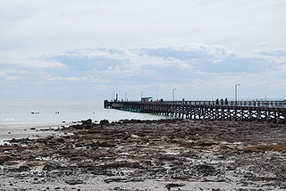
Stansbury is a small town, located in the southern east coast of Yorke Peninsula, South Australia. At the 2016 census, Stansbury had a population of 648 people. It is located 25 kilometres (16 mi) south of Minlaton and 22 kilometres (14 mi) east of Yorketown. It faces the Gulf St Vincent across Oyster Bay, where shellfish were originally harvested in the 19th century. The town has also been a port used in the export of wheat and barley to Adelaide.

<span class="mw-page-title-main">Clinton, South Australia</span> Town in South Australia

Clinton is a locality in the Australian state of South Australia located on the east coast of Yorke Peninsula overlooking the north west head of Gulf St Vincent about 101 kilometres (63 mi) west of the state capital of Adelaide and about 36 kilometres (22 mi) north-east of the municipal seat of Maitland.

<span class="mw-page-title-main">Coobowie</span> Town in South Australia

Coobowie is a town in the Australian state of South Australia near the south-eastern tip of Yorke Peninsula. Coobowie was proclaimed in 1875. Coobowie comes from an Aboriginal word meaning "wild fowl water". At the 2011 census, Coobowie shared a population of 220 with other localities. Coobowie's current outlook is to create many new features including making improvements to the foreshore play area.

<span class="mw-page-title-main">Curramulka</span> Town in South Australia

Curramulka is a town in the Australian state of South Australia on the Yorke Peninsula. Curramulka is within easy driving distance of the coastal resort towns of Port Victoria and Port Vincent and is 15 kilometres (9.3 mi) north-east of Minlaton. At the 2016 census, Curramulka had a population of 305.

Sultana Point is a locality in the Australian state of South Australia located on the Yorke Peninsula immediately adjoining the western head of Gulf St Vincent about 80 kilometres west of the state capital of Adelaide.

<span class="mw-page-title-main">Port Arthur, South Australia</span> Town in South Australia

Port Arthur is a locality in the Australian state of South Australia located on the Yorke Peninsula at the northern end of Gulf St Vincent about 105 kilometres north west of the state capital of Adelaide and about 9 kilometres north of the town of Port Wakefield.

<span class="mw-page-title-main">Hardwicke Bay, South Australia</span> Town in South Australia

Hardwicke Bay is a locality in the Australian state of South Australia located on the west coast of Yorke Peninsula overlooking the bay also named Hardwicke Bay about 104 kilometres west of the Adelaide city centre and about 9 kilometres north of the town of Warooka.

<span class="mw-page-title-main">Inneston, South Australia</span> Suburb of Yorke Peninsula Council, South Australia

Inneston is a locality in the Australian state of South Australia located on the south-western end of Yorke Peninsula about 155 kilometres west of the state capital of Adelaide. Historically, it is notable as a site for the mining of gypsum and since 1970, the majority of the land within the current extent of the locality is within the protected area called the Dhilba Guuranda–Innes National Park.

Foul Bay is a locality in the Australian state of South Australia located on the south coast of Yorke Peninsula immediately adjoining Investigator Strait about 130 kilometres west of the state capital of Adelaide.

Nalyappa is a locality in the Australian state of South Australia located on the west coast of Yorke Peninsula immediately adjoining Spencer Gulf about 128 kilometres north-west of the state capital of Adelaide.

<span class="mw-page-title-main">Port Julia, South Australia</span> Suburb of Yorke Peninsula Council, South Australia

Port Julia is a locality in the Australian state of South Australia located on the east coast of Yorke Peninsula about 72 kilometres northwest of the Adelaide city centre.

References

  1. 1 2 3 4 5 6 "Search results for 'Wool Bay, LOCB' with the following datasets selected – 'Suburbs and localities', 'Counties', 'Government Towns', 'Local Government Areas', 'SA Government Regions' and 'Gazetteer'". Location SA Map Viewer. South Australian Government. Retrieved 17 January 2019.
  2. Australian Bureau of Statistics (27 June 2017). "Wool Bay (State Suburb)". 2016 Census QuickStats. Retrieved 17 January 2019. OOjs UI icon edit-ltr-progressive.svg
  3. 1 2 Musgrave, A. (24 August 1876). "Untitled proclamation re the Township of Pickering" (PDF). The South Australian Government Gazette. Government of South Australia. p. 1633. Retrieved 17 January 2019.
  4. Kentish, P.M. (27 May 1999). "GEOGRAPHICAL NAMES ACT 1991 Notice to Assign Boundaries and Names to Places (in the District Council of Yorke Peninsula)" (PDF). The South Australian Government Gazette. Government of South Australia. p. 2696. Retrieved 17 January 2019.
  5. "Postcode for Wool Bay, South Australia". Postcodes Australia. Retrieved 17 January 2019.
  6. 1 2 Narungga (Map). Electoral District Boundaries Commission. 2016. Retrieved 1 March 2018.
  7. 1 2 "Federal electoral division of Grey" (PDF). Australian Electoral Commission. Retrieved 24 July 2015.
  8. 1 2 3 "Monthly climate statistics: Summary statistics EDITHBURGH (nearest weather station)". Commonwealth of Australia , Bureau of Meteorology. Retrieved 17 January 2019.
  9. "Wool Bay". Boat ramp locations. Yorke Peninsula Council . Retrieved 15 January 2019.
  10. "NEW TOWN NAMES APPROVED". The Chronicle . Vol. LXXXIII, no. 4, 728. South Australia. 1 August 1940. p. 13. Retrieved 31 August 2016 via National Library of Australia.
  11. "WOOL BAY LIME. NEW KILN ESTABLISHED". The Advertiser. Adelaide. 13 August 1910. Retrieved 1 April 2016.
  12. Lee, Kel (16 September 2014). "History hidden in seaside cliffs". Weekend Notes. OatLabs. Retrieved 15 January 2019.
  13. "Wool Bay Lime Kiln & Jetty". SA Heritage Places database search. 28 November 1985. Retrieved 15 January 2019.