
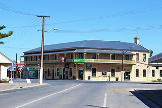
Edithburgh is a small town on the south-east corner of Yorke Peninsula situated on the coastline of Salt Creek Bay, in the state of South Australia. Edithburgh is about 50 km (31 mi) west of Adelaide across Gulf St Vincent, but 226 km (140 mi) away by road. At the 2016 census, the locality had a population of 516 of which 454 lived in its town centre.
Yorketown is a town and a locality in the Australian state of South Australia located in the southern Yorke Peninsula about 91 kilometres (57 mi) west of the state capital of Adelaide and about 70 kilometres (43 mi) south of the municipal seat of Maitland. At the 2016 census, the locality had a population of 969 of which 642 lived in its town centre.

Coobowie is a town in the Australian state of South Australia near the south-eastern tip of Yorke Peninsula. Coobowie was proclaimed in 1875. Coobowie comes from an Aboriginal word meaning "wild fowl water". At the 2011 census, Coobowie shared a population of 220 with other localities. Coobowie's current outlook is to create many new features including making improvements to the foreshore play area.
Wallaroo Plain is a locality in the Australian state of South Australia located on the west coast of Yorke Peninsula immediately adjoining Spencer Gulf about 148 kilometres north-west of the state capital of Adelaide.
Honiton is a locality in the Australian state of South Australia located on the south coast of Yorke Peninsula immediately adjoining Investigator Strait about 89 kilometres west of the state capital of Adelaide and about 5 kilometres west of the Edithburgh town centre.
Foul Bay is a locality in the Australian state of South Australia located on the south coast of Yorke Peninsula immediately adjoining Investigator Strait about 130 kilometres west of the state capital of Adelaide.

Dowlingville is a locality in the Australian state of South Australia located on the east coast of Yorke Peninsula immediately adjoining Gulf St Vincent about 89 kilometres north-west of the state capital of Adelaide. Its boundaries were created in May 1999.
Tiddy Widdy Beach is a locality in the Australian state of South Australia located on the east coast of Yorke Peninsula immediately adjoining Gulf St Vincent about 84 kilometres northwest of the Adelaide city centre and about 5 kilometres northeast of the centre of Ardrossan.

James Well is a locality in the Australian state of South Australia located on the east coast of Yorke Peninsula immediately adjoining Gulf St Vincent about 84 kilometres north-west of the state capital of Adelaide and about 5 kilometres of the centre of Ardrossan.
Rogues Point is a locality in the Australian state of South Australia located on the east coast of Yorke Peninsula immediately adjoining Gulf St Vincent, about 80 kilometres north-west of the Adelaide city centre and about 6.9 kilometres of the centre of Ardrossan.
Nalyappa is a locality in the Australian state of South Australia located on the west coast of Yorke Peninsula immediately adjoining Spencer Gulf about 128 kilometres north-west of the state capital of Adelaide.
Chinaman Wells is a locality in the Australian state of South Australia located on the west coast of Yorke Peninsula immediately adjoining Spencer Gulf about 119 kilometres north-west of the state capital of Adelaide.
Couch Beach is a locality in the Australian state of South Australia located on the western side of Yorke Peninsula on the portion forming the south coast of Hardwicke Bay in Spencer Gulf about 130 kilometres west of the state capital of Adelaide.
The Pines is a locality in the Australian state of South Australia located on the western side of Yorke Peninsula on the portion forming the south coast of Hardwicke Bay in Spencer Gulf about 131 kilometres west of the Adelaide city centre.
Point Souttar is a locality in the Australian state of South Australia located on the western side of Yorke Peninsula on the portion forming the south coast of Hardwicke Bay in Spencer Gulf about 121 kilometres west of the Adelaide city centre.
Black Point is a locality in the Australian state of South Australia located on the east coast of Yorke Peninsula about 72 kilometres northwest of the state capital of Adelaide.

Port Julia is a locality in the Australian state of South Australia located on the east coast of Yorke Peninsula about 72 kilometres northwest of the Adelaide city centre.
Bluff Beach is a locality in the Australian state of South Australia located on the west coast of Yorke Peninsula overlooking Hardwicke Bay about 104 kilometres west of the state capital of Adelaide.
Clinton Centre is a locality in the Australian state of South Australia located on the northern end of Yorke Peninsula about 99 kilometres north-west of the state capital of Adelaide and about 27 kilometres north-east of the municipal seat in Maitland.
Wauraltee is a locality in the Australian state of South Australia located on the Yorke Peninsula about 102 kilometres (63 mi) west of the state capital of Adelaide and about 25 kilometres (16 mi) south-west of the municipal seat of Maitland.
