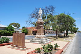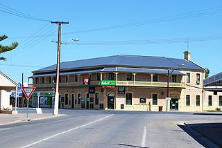
Yorketown is a town and a locality in the Australian state of South Australia located in the southern Yorke Peninsula about 91 kilometres (57 mi) west of the state capital of Adelaide and about 70 kilometres (43 mi) south of the municipal seat of Maitland. At the 2016 census, the locality had a population of 969 of which 642 lived in its town centre.

Kadina is a town on the Yorke Peninsula of the Australian state of South Australia, approximately 144 kilometres north-northwest of the state capital of Adelaide. The largest town of the Peninsula, Kadina is one of the three Copper Triangle towns famous for their shared copper mining history. The three towns are known as "Little Cornwall" for the significant number of immigrants from Cornwall who worked at the mines in the late 19th century.

Maitland is a town in South Australia. By road, it is 168 km west of Adelaide by, 164 km south of Port Pirie and 46 km north of Minlaton known as the "heart of Yorke Peninsula" due to being near the centre of the region. At the 2016 census, Maitland had a population of 1,029.
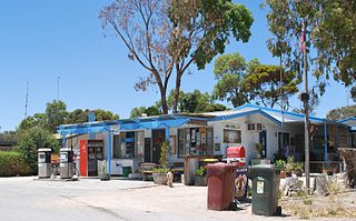
Balgowan is a small coastal town on the west coast of South Australia's Yorke Peninsula. It is located approximately 20 kilometres west of Maitland. Like other towns on popular with tourists on Yorke Peninsula, it has a large number of shacks, holiday houses, caravan facilities and a boat ramp. The population generally increases during peak holiday periods.

Brentwood is a locality on the Yorke Peninsula in South Australia. With a population of 77 at the time of the 2016 census The town is located in the Yorke Peninsula Council local government area, 212 kilometres (132 mi) west of the state capital, Adelaide by road. It is on the Yorke Highway, between Minlaton and Hardwicke Bay.
Kainton is a small town in the Australian state of South Australia situated about 10 km south of Paskeville in the upper Yorke Peninsula.

Port Arthur is a locality in the Australian state of South Australia located on the Yorke Peninsula at the northern end of Gulf St Vincent about 105 kilometres north west of the state capital of Adelaide and about 9 kilometres north of the town of Port Wakefield.
Foul Bay is a locality in the Australian state of South Australia located on the south coast of Yorke Peninsula immediately adjoining Investigator Strait about 130 kilometres west of the state capital of Adelaide.
White Hut is a locality in the Australian state of South Australia. It is on the west coast of Yorke Peninsula immediately adjoining Spencer Gulf about 145 kilometres west of the state capital of Adelaide. Its boundaries were created in May 1999. As of 2014, the majority of the land within the locality is zoned as “water protection” to protect groundwater basins present at “shallow depths” and to encourage land use such as “broadacre cropping, grazing, and wind farm and ancillary development.” White Hut is within the federal division of Grey, the state electoral district of Narungga and the local government area of the Yorke Peninsula Council.

Dowlingville is a locality in the Australian state of South Australia located on the east coast of Yorke Peninsula immediately adjoining Gulf St Vincent about 89 kilometres north-west of the state capital of Adelaide. Its boundaries were created in May 1999.
Tiddy Widdy Beach is a locality in the Australian state of South Australia located on the east coast of Yorke Peninsula immediately adjoining Gulf St Vincent about 84 kilometres northwest of the Adelaide city centre and about 5 kilometres northeast of the centre of Ardrossan.
Sheaoak Flat is a locality in South Australia located on the east coast of Yorke Peninsula immediately adjoining Gulf St Vincent about 71 kilometres north-west of the Adelaide city centre.
Nalyappa is a locality in the Australian state of South Australia located on the west coast of Yorke Peninsula immediately adjoining Spencer Gulf about 128 kilometres north-west of the state capital of Adelaide.
Chinaman Wells is a locality in the Australian state of South Australia located on the west coast of Yorke Peninsula immediately adjoining Spencer Gulf about 119 kilometres north-west of the state capital of Adelaide.
The Pines is a locality in the Australian state of South Australia located on the western side of Yorke Peninsula on the portion forming the south coast of Hardwicke Bay in Spencer Gulf about 131 kilometres west of the Adelaide city centre.

Port Julia is a locality in the Australian state of South Australia located on the east coast of Yorke Peninsula about 72 kilometres northwest of the Adelaide city centre.
Bluff Beach is a locality in the Australian state of South Australia located on the west coast of Yorke Peninsula overlooking Hardwicke Bay about 104 kilometres west of the state capital of Adelaide.
Clinton Centre is a locality in the Australian state of South Australia located on the northern end of Yorke Peninsula about 99 kilometres north-west of the state capital of Adelaide and about 27 kilometres north-east of the municipal seat in Maitland.
Wauraltee is a locality in the Australian state of South Australia located on the Yorke Peninsula about 102 kilometres (63 mi) west of the state capital of Adelaide and about 25 kilometres (16 mi) south-west of the municipal seat of Maitland.
Koolywurtie is a locality in the Australian state of South Australia located on the Yorke Peninsula about 93 kilometres (58 mi) west of the state capital of Adelaide and about 20 kilometres (12 mi) south of the municipal seat of Maitland.