This page is based on this
Wikipedia article Text is available under the
CC BY-SA 4.0 license; additional terms may apply.
Images, videos and audio are available under their respective licenses.

Minlaton is a town in central Yorke Peninsula, South Australia. At the 2016 census, Minlaton had a population of 800. It is known as the "Barley capital of the world", due to the rich Barley production in the region.

Baird Bay is a small fishing village located 50 kilometres south of Streaky Bay on the west coast of Eyre Peninsula in South Australia. It is situated on the east coast of a bay named Baird Bay which opens into the north end of Anxious Bay.

D'Estrees Bay is a bay in the Australian state of South Australia located on the southern coast of Kangaroo Island about 39 kilometres south of Kingscote, the Island's principal centre.

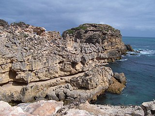
Cape Jaffa is a headland in the Australian state of South Australia located at the south end of Lacepede Bay on the state's south east coast about 20 kilometres south west of the town centre of Kingston SE. The cape is described as being "a low sandy point" with "its sea face is about One nautical mile (1.9 km) long" and having a "wooded range rises near the S[outh] part of the cape and reaches a height of 77 metres at Mount Benson, about 8.5 nautical miles S[outh] E[ast]". A settlement known as King's Camp in some sources and as Cape Jaffa in other sources is located about 0.5 nautical miles to the north west of the cape. This settlement includes a jetty fitted with a navigation aid and a marina. The southern coastline of the cape forms part of the Bernouilli Conservation Reserve.

Nepean Bay is a bay located on the north-east coast of Kangaroo Island in the Australian state of South Australia about 130 kilometres south-south-west of Adelaide. It was named by the British navigator, Matthew Flinders, after Sir Evan Nepean on 21 March 1802.
Kangaroo Head is a headland in the Australian state of South Australia located at the north-west tip of Dudley Peninsula on Kangaroo Island. It was named by the British explorer, Matthew Flinders, on 23 March 1802.
Troubridge Point is a headland in the Australian state of South Australia located on the south coast of Yorke Peninsula about 11 kilometres south west of Edithburgh. It is the western end of the opening to Gulf St Vincent.

Rosetta Head, which is more commonly known as The Bluff, is a headland located on the south coast of Fleurieu Peninsula in the Australian state of South Australia in the suburb of Encounter Bay within the local government area of the City of Victor Harbor and about 77 kilometres south of the state capital of Adelaide. It is a prominent landmark on the coast of Encounter Bay which is currently used as a recreational reserve and which is notable as a platform to view the adjoining coast and surrounding countryside.
Troubridge Hill is a hill on the south coast of Yorke Peninsula in South Australia located in the locality of Honiton about 13.5 kilometres south west of Edithburgh and about 3.8 kilometres west of Troubridge Point. It was discovered, reported as being a ’hummock upon this low part ’ and named by Matthew Flinders on 24 March 1802 after Sir Thomas Troubridge, 1st Baronet. Since 1980, it has been the site of an operating lighthouse known as the Troubridge Hill Lighthouse. Its adjoining coastline borders a protected area of the same name - the Troubridge Hill Aquatic Reserve.
Cape Northumberland is a headland in the southeast of the Australian state of South Australia. It is the southernmost point of South Australia. It is located about 3 kilometres (1.9 mi) from the town of Port MacDonnell, 28 kilometres south southwest from the municipal seat of Mount Gambier and about 393 kilometres (244 mi) southeast of the state's capital Adelaide.

Calca Peninsula is a peninsula in the Australian state of South Australia located on the west coast of Eyre Peninsula in the locality of Sceale Bay about 27 kilometres to about 46 kilometres south-east of the town of Streaky Bay.
Hardwicke Bay is a bay in the Australian state of South Australia located on the west coast of Yorke Peninsula in Spencer Gulf.

Sleaford is a locality in the Australian state of South Australia located at the southern tip of the Eyre Peninsula overlooking the Great Australian Bight about 260 kilometres west of the state capital of Adelaide and about 17 kilometres west of the municipal seat of Port Lincoln.

County of Fergusson is a cadastral unit located in the Australian state of South Australia which spans Yorke Peninsula south of Price. It was proclaimed in 1869 by Governor Fergusson after whom the county was named.
The Hundred of Koolywurtie is a hundred in the county of County of Fergusson in South Australia. Proclaimed on 31 December 1874, it covers an area of 320 square kilometres (123 sq mi). Its name is thought to be derived from the place known as "Koolywurtie or Black Point." The first local government body within the hundred was the District Council of Minlaton.
County of Manchester is a cadastral unit located in the Australian state of South Australia that covers land both located in the north-east of Eyre Peninsula and to the peninsula's north. It was proclaimed in 1891 and named after George Montagu, 6th Duke of Manchester who was the father-in-law of the Rt Hon. Earl of Kintore GCMG, the Governor of South Australia at the time.

The County of Jervois is a cadastral unit in the Australian state of South Australia that covers land on the east coast of the Eyre Peninsula. It was proclaimed on 24 January 1878 and named after William Jervois, the Governor of South Australia from October 1877 to January 1883.

Pink Bay is a bay in the Australian state of South Australia and is located at the east end of Dudley Peninsula on Kangaroo Island overlooking Backstairs Passage in the gazetted locality of Willoughby about 110 kilometres (68 mi) south of the state capital of Adelaide and about 20 kilometres (12 mi) east of Penneshaw.
Moncrieff Bay is a bay in the Australian state of South Australia located at the east end of the Dudley Peninsula on Kangaroo Island in the gazetted locality of Willoughby overlooking Backstairs Passage about 106 kilometres (66 mi) south-west of the state capital of Adelaide and about 47 kilometres (29 mi) south-east of the municipal seat of Kingscote.
Sleaford Bay is a bay located in the Australian state of South Australia on the southern coast of Eyre Peninsula. It was named by the British navigator, Matthew Flinders in 1802.


