
Dhilba Guuranda-Innes National Park is a protected area in the Australian state of South Australia located on the southwest tip of Yorke Peninsula about 300 kilometres (190 mi) west of the state capital of Adelaide. It is a popular destination for camping, bushwalking, fishing, surfing and scuba diving.

Troubridge Island is an island located in the south west corner of Gulf St Vincent in South Australia near the eastern edge of the Troubridge Shoals off the east coast of Yorke Peninsula about 8 kilometres (5.0 mi) southeast by east of the town of Edithburgh It is notable for being a site of an operating lighthouse from 1856 until 2002 and as a site for a sea bird rookery. Since 1982, the island has been part of the Troubridge Island Conservation Park.

Nepean Bay is a bay located on the north-east coast of Kangaroo Island in the Australian state of South Australia about 130 kilometres south-south-west of Adelaide. It was named by the British navigator, Matthew Flinders, after Sir Evan Nepean on 21 March 1802.

Chinamans Hat Island is an islet located off the south coast of Yorke Peninsula in Investigator Strait in South Australia about 2.4 kilometres south-west of Stenhouse Bay and within 350 metres of the shore. As of 2014, it is located within the Innes National Park.
Guichen Bay, is a bay located on the south-east coast of the Australian state of South Australia about 115 kilometres northwest of the regional city of Mount Gambier and about 270 kilometres south-southeast of the state capital of Adelaide. It was named in 1802 by the Baudin expedition of 1800-03 after Luc Urbain de Bouëxic, comte de Guichen. The town of Robe is located at the southern end of the bay.

Royston Head is a headland in the Australian state of South Australia located on the west coast of the south-west tip of Yorke Peninsula. It forms the northern extremity of Pondalowie Bay and is connected to an island of the same name by a drying reef. It was reported as being named after Lord Royston, eldest son of Lord Hardwicke by Matthew Flinders. The head is within the Innes National Park while the waters adjoining its shores are located within the boundaries of the Southern Spencer Gulf Marine Park.

Aldinga Bay is a bay located on the east coast of Gulf St Vincent in South Australia about 40 kilometres south-southwest of Adelaide city centre.

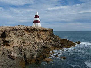
West Cape is a headland located on the west coast of the Yorke Peninsula in South Australia in the gazetted locality of Inneston about 14 kilometres west of the town of Marion Bay. It is the most westerly point of Yorke Peninsula. Since 1970, the headland has been located within the Innes National Park while the waters adjoining its shoreline have been located within the Southern Spencer Gulf Marine Park since 2012. Since 1980, it has been the site of a navigation aid in the form of a lighthouse.

Corny Point is a headland located on the west coast of the Yorke Peninsula in South Australia about 37 kilometres north west of the town of Warooka. The point is described as being "a sloping rocky double projection..." where the "coast on the N[orth] side is low and sandy whereas the coast on the S[outh] side is higher than the point itself." It is the south headland of Hardwicke Bay. It was named by Matthew Flinders on 18 March 1802. The waters adjoining its shoreline are within the Southern Spencer Gulf Marine Park. Since 1882, it has been the site of a navigation aid in the form of a lighthouse.
Beatrice Islets are pair of islets in the Australian state of South Australia located in Nepean Bay on the north coast of Kangaroo Island about 4 kilometres east of Kingscote. The islets and adjoining intertidal areas are notable as habitat for bird life. The islet pair has enjoyed protected area status since 1909 and since at least 1972, have been part of the Beatrice Islet Conservation Park. During either the 1960s or the 1970s, the islets were extensively damaged by an exercise to remove an infestation of South African boxthorn.
Nicolas Baudin Island is an island in the Australian state of South Australia about 500 metres west of Cape Blanche on the west coast of Eyre Peninsula about 25 kilometres south south-west of the town of Streaky Bay. The island is notable as a breeding site for Australian sea lions. The island has enjoyed protected area status since 2003 when it became part of the Nicolas Baudin Island Conservation Park.
Topgallant Islands is an island group in the Australian state of South Australia located in the Investigator Group about 22 kilometres south west of Cape Finniss on the west coast of Eyre Peninsula. The group was discovered and named by Matthew Flinders on 13 February 1802. The island group has enjoyed protected area status since the 1960s and since 2011, it has been part of the Investigator Group Wilderness Protection Area.

Point Avoid is a headland located at the south eastern extremity of both Coffin Bay Peninsula and Avoid Bay on the west coast of Eyre Peninsula in South Australia about 15 kilometres south west of the town of Coffin Bay. It was described in 2017 as being “fronted on all of its seaward sides by limestone cliffs, about 46 metres high, which change abruptly to sand hills E of its S(outhern) extremity.” It was named by Matthew Flinders on 17 February 1802 to acknowledge the navigational hazards present around its shores. The point is currently located within the boundaries of the protected area, the Coffin Bay National Park.
Slade Point is a headland in the Australian state of South Australia located on the west coast of Eyre Peninsula in the locality of Sceale Bay about 29 kilometres (18 mi) south of the town of Streaky Bay. The point is the northern extremity of Searcy Bay and the southern extremity of a promontory that separates Searcy Bay in the south east from Sceale Bay in the north west. While it is within the coastline first charted by Matthew Flinders on 9 February 1802, it is not named by Flinders possibly due to the coastline being obscured by a thick haze. Slade Point was named in 1908 after “the late Mr. W. E. Slade” who served as the Assistant Engineer of Harbours in the South Australian Government. The cape has adjoined the boundary of the Cape Blanche Conservation Park since 2012 while the waters adjoining its shoreline have been within a habitat protection zone in the West Coast Bays Marine Park also since 2012.
Royston Island is an island in the Australian state of South Australia at the northern end of Pondalowie Bay on the south-west extremity of Eyre Peninsula about 13 kilometres north-west of the town of Stenhouse Bay. The island has enjoyed protected area status since 1967 and since 1972, it has been part of the Innes National Park.

South Island is an island located in the Australian state of South Australia at the south end of Pondalowie Bay on the south-west extremity of Yorke Peninsula about 11 kilometres north-west by west of the town of Stenhouse Bay. The island has enjoyed protected area status since 1970 and since 1977, it has been part of the Innes National Park.
Hardwicke Bay is a bay in the Australian state of South Australia located on the west coast of Yorke Peninsula in Spencer Gulf.
Inneston is a locality in the Australian state of South Australia located on the south-western end of Yorke Peninsula about 155 kilometres west of the state capital of Adelaide. Historically, it is notable as a site for the mining of gypsum and since 1970, the majority of the land within the current extent of the locality is within the protected area called the Innes National Park.
Germein Bay is a bay in the Australian state of South Australia located at the northern end Spencer Gulf on the gulf's east coast to the immediate north of the city of Port Pirie. Its extent includes the port known as ‘Port Pirie’ and the former port of Port Germein. Since 2012, the majority of the bay has been within the protected area known as the Upper Spencer Gulf Marine Park.

Sleaford Bay is a bay located in the Australian state of South Australia on the southern coast of Eyre Peninsula. It was named by the British navigator, Matthew Flinders in 1802.


