Human settlement

Last updated
The small town of Flora, Oregon, in United States, is unincorporated, but is considered a populated place. Flora OR - aerial.jpg
The small town of Flora, Oregon, in United States, is unincorporated, but is considered a populated place.
A field landscape of the rural Pajuniemi village in Sastamala, Pirkanmaa, Finland Pajuniemen kylaaukeaa Suodenniemella.jpg
A field landscape of the rural Pajuniemi village in Sastamala, Pirkanmaa, Finland
Taos Pueblo, an ancient pueblo belonging to a Taos-speaking Native American tribe of Pueblo people. It is approximately 1000 years old and lies about 1 mile (1.6 km) north of the modern city of Taos, New Mexico. Taos Pueblo2.jpg
Taos Pueblo, an ancient pueblo belonging to a Taos-speaking Native American tribe of Pueblo people. It is approximately 1000 years old and lies about 1 mile (1.6 km) north of the modern city of Taos, New Mexico.
London, a city in the United Kingdom, is a large settlement with a human population of 14 million in its metropolitan area. Palace of Westminster from the dome on Methodist Central Hall.jpg
London, a city in the United Kingdom, is a large settlement with a human population of 14 million in its metropolitan area.

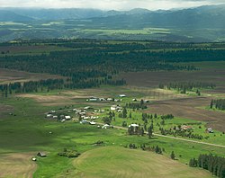
In geography, statistics and archaeology, a settlement, locality or populated place is a community of people living in a particular place. The complexity of a settlement can range from a minuscule number of dwellings grouped together to the largest of cities with surrounding urbanized areas. Settlements may include hamlets, villages, towns and cities. A settlement may have known historical properties such as the date or era in which it was first settled, or first settled by particular people. The process of settlement involves human migration.

Contents

In the field of geospatial predictive modeling, settlements are "a city, town, village or other agglomeration of buildings where people live and work". [1]

A settlement conventionally includes its constructed facilities such as roads, enclosures, field systems, boundary banks and ditches, ponds, parks and woodlands, wind and water mills, manor houses, moats and churches. [2]

An unincorporated area is a related designation used in the United States.

History

The earliest geographical evidence of a human settlement was Jebel Irhoud, where early modern human remains of eight individuals date back to the Middle Paleolithic around 300,000 years ago.

The oldest remains that have been found of constructed dwellings are remains of huts that were made of mud and branches around 17,000 BC at the Ohalo site (now underwater) near the edge of the Sea of Galilee. The Natufians built houses, also in the Levant, around 10,000 BC. Remains of settlements such as villages become much more common after the invention of agriculture, The oldest of them is Jarmo, Located in iraq.

In landscape history

Some settlement sites may go out of use. This location in Estonia was used for human settlement in 2nd half of first millennium and it is considered an archaeological record, that may provide information on how people lived back then. Eoste Keldrimagi.JPG
Some settlement sites may go out of use. This location in Estonia was used for human settlement in 2nd half of first millennium and it is considered an archaeological record, that may provide information on how people lived back then.

Landscape history studies the form (morphology) of settlements – for example whether they are dispersed or nucleated. Urban morphology can thus be considered a special type of cultural-historical landscape studies. Settlements can be ordered by size, centrality or other factors to define a settlement hierarchy. A settlement hierarchy can be used for classifying settlement all over the world, although a settlement called a "town" in one country might be a "village" in other countries; or a "large town" in some countries might be a "city" in others.

Statistics

Australia

Geoscience Australia defines a populated place as "a named settlement with a population of 200 or more persons". [3]

The Committee for Geographical Names in Australasia used the term localities for rural areas, while the Australian Bureau of Statistics uses the term "urban centres/localities" for urban areas.[ citation needed ]

Bosnia and Herzegovina

The Agency for Statistics in Bosnia and Herzegovina uses the term "populated place" /"settled place" for rural (or urban as an administrative center of some Municipality/City), and "Municipality" and "City" for urban areas.

Bulgaria

The Bulgarian Government publishes a National Register of Populated places (NRPP).

Canada

The Canadian government uses the term "populated place" in the Atlas of Canada , but does not define it. [4] Statistics Canada uses the term localities for historically named locations.

Croatia

The Croatian Bureau of Statistics records population in units called settlements (naselja).

India

The Census Commission of India has a special definition of census towns.

Ireland

The Central Statistics Office (CSO) of the Republic of Ireland has had a special definition of census towns. From the 2022 census of Ireland, the CSO introduced an urban geography unit called "Built Up Areas" (BUAs). [5]

Pakistan

The Pakistan Bureau of Statistics records population in units of settlements called Tehsil – an administrative unit derived from the Mughal era.

Russia

Urban structure of Sortavala, a town in Republic of Karelia, Russia Sortavala - streets of Ulitsa Karel'skaya & Ulitsa Vyaynemyaynena.jpg
Urban structure of Sortavala, a town in Republic of Karelia, Russia

There are various types of inhabited localities in Russia.

Sweden

Statistics Sweden uses the term localities (tätort) for various densely populated places. The common English-language translation is urban areas.

United Kingdom

The UK Department for Communities and Local Government uses the term "urban settlement" to denote an urban area when analysing census information. [6] The Registrar General for Scotland defines settlements as groups of one or more contiguous localities, which are determined according to population density and postcode areas. The Scottish settlements are used as one of several factors defining urban areas. [7]

United States

The United States Geological Survey (USGS) has a Geographic Names Information System that defines three classes of human settlement:

  1. Populated placeplace or geographic area with clustered or scattered buildings and a permanent human population (city, settlement, town, village). A populated place is usually not incorporated and by definition has no legal boundaries. However, a populated place may have a corresponding "civil" record, the legal boundaries of which may or may not coincide with the perceived populated place. [8]
  2. Census − a statistical area delineated locally specifically for the tabulation of Census Bureau data (census designated place, census county division, unorganized territory, various types of American Indian/Alaska Native statistical areas). [8]
  3. Civil − a political division formed for administrative purposes (borough, county, incorporated place, municipality, parish, town, township). [8]

Populated places may be specifically defined in the context of censuses and be different from general-purpose administrative entities, such as "place" as defined by the U.S. Census Bureau or census-designated places.

Geospatial modeling

In the field of geospatial predictive modeling, a settlement is "a city, town, village, or other agglomeration of buildings where people live and work". [1]

The Global Human Settlement Layer (GHSL) framework produces global spatial information about the human presence on the planet over time. This in the form of built up maps, population density maps and settlement maps. This information is generated with evidence-based analytics and knowledge using new spatial data mining technologies. The framework uses heterogeneous data including global archives of fine-scale satellite imagery, census data, and volunteered geographic information. The data is processed fully automatically and generates analytics and knowledge reporting objectively and systematically about the presence of population and built-up infrastructures. The GHSL operates in an open and free data and methods access policy (open input, open method, open output).

Abandonment

Abandoned buildings in Kolmanskop, Namibia Namibie Kolmanskop 05.JPG
Abandoned buildings in Kolmanskop, Namibia

The term "Abandoned populated places" is a Feature Designation Name in databases sourced by the National Geospatial-Intelligence Agency [10] and GeoNames. [11]

Sometimes the structures are still easily accessible, such as in a ghost town, and these may become tourist attractions. Some places that have the appearance of a ghost town, however, may still be defined as populated places by government entities.[ citation needed ]

A town may become a ghost town because the economic activity that supported it has failed, because of a government action, such as the building of a dam that floods the town, or because of natural or human-caused disasters such as floods, uncontrolled lawlessness, or war. The term is sometimes used to refer to cities, towns, and neighborhoods that are still populated, but significantly less so than in years past.[ citation needed ]

See also

Related Research Articles

<span class="mw-page-title-main">Town</span> Type of human settlement

A town is a type of a human settlement. Towns are generally larger than villages and smaller than cities, though the criteria to distinguish between them vary considerably in different parts of the world.

<span class="mw-page-title-main">Metropolitan area</span> Administrative unit of a dense urban core and its satellite cities

A metropolitan area or metro is a region consisting of a densely populated urban agglomeration and its surrounding territories sharing industries, commercial areas, transport network, infrastructures and housing. A metropolitan area usually comprises multiple principal cities, jurisdictions and municipalities: neighborhoods, townships, boroughs, cities, towns, exurbs, suburbs, counties, districts and even states and nations in areas like the eurodistricts. As social, economic and political institutions have changed, metropolitan areas have become key economic and political regions.

A census tract, census area, census district or meshblock is a geographic region defined for the purpose of taking a census. Sometimes these coincide with the limits of cities, towns or other administrative areas and several tracts commonly exist within a county. In unincorporated areas of the United States these are often arbitrary, except for coinciding with political lines.

<span class="mw-page-title-main">Population density</span> Measurement of population per unit area or unit volume

Population density is a measurement of population per unit land area. It is mostly applied to humans, but sometimes to other living organisms too. It is a key geographical term.

A census-designated place (CDP) is a concentration of population defined by the United States Census Bureau for statistical purposes only.

<span class="mw-page-title-main">Hamlet (place)</span> Small human settlement in a rural area

A hamlet is a human settlement that is smaller than a town or village. This is often simply an informal description of a smaller settlement or possibly a subdivision or satellite entity to a larger settlement.

<span class="mw-page-title-main">Census geographic units of Canada</span> Term used in Canada

The census geographic units of Canada are the census subdivisions defined and used by Canada's federal government statistics bureau Statistics Canada to conduct the country's quinquennial census. These areas exist solely for the purposes of statistical analysis and presentation; they have no government of their own. They exist on four levels: the top-level (first-level) divisions are Canada's provinces and territories; these are divided into second-level census divisions, which in turn are divided into third-level census subdivisions and fourth-level dissemination areas.

<span class="mw-page-title-main">Urban area</span> Human settlement with high population density and infrastructure of built environment

An urban area, built-up area or urban agglomeration is a human settlement with a high population density and an infrastructure of built environment. This is the core of a metropolitan statistical area in the United States, if it contains a population of more than 50,000.

An urban area or tätort in Sweden has a minimum of 200 inhabitants and may be a city, town or larger village. It is a purely statistical concept, not defined by any municipal or county boundaries. Larger urban areas synonymous with cities or towns for statistical purposes have a minimum of 10,000 inhabitants. The same statistical definition is also used for urban areas in the other Nordic countries.

<span class="mw-page-title-main">Spatial analysis</span> Formal techniques which study entities using their topological, geometric, or geographic properties

Spatial analysis is any of the formal techniques which studies entities using their topological, geometric, or geographic properties. Spatial analysis includes a variety of techniques using different analytic approaches, especially spatial statistics. It may be applied in fields as diverse as astronomy, with its studies of the placement of galaxies in the cosmos, or to chip fabrication engineering, with its use of "place and route" algorithms to build complex wiring structures. In a more restricted sense, spatial analysis is geospatial analysis, the technique applied to structures at the human scale, most notably in the analysis of geographic data. It may also be applied to genomics, as in transcriptomics data.

The United States Census Bureau defines a place as a concentration of population which has a name, is locally recognized, and is not part of any other place. A place typically has a residential nucleus and a closely spaced street pattern, and it frequently includes commercial property and other urban land uses. A place may be an incorporated place or it may be a census-designated place (CDP). Incorporated places are defined by the laws of the states in which they are contained. The Census Bureau delineates CDPs. A small settlement in the open countryside or the densely settled fringe of a large city may not be a place as defined by the Census Bureau. As of the census, 26% of the people in the United States lived outside of places.

<span class="mw-page-title-main">Outline of geography</span> Hierarchical outline list of articles related to geography

The following outline is provided as an overview of and topical guide to geography:

<span class="mw-page-title-main">Populated places in Ukraine</span>

In Ukraine, a populated place refers to a structured component of the human settlement system, representing a stationary community within a territorially cohesive and compact area characterized by a significant concentration of population. Its defining attribute is the continuous presence of human inhabitants. Populated places in Ukraine are classified into two primary categories: urban and rural. Urban populated places are cities, whereas rural areas include villages and rural settlements. According to data from the 2001 Ukrainian Census, there are 1,344 urban and 28,621 rural populated places in Ukraine.

<span class="mw-page-title-main">Core city</span> Largest or most important city of a metropolitan area

In urban planning, a historic core city or central city is the municipality with the largest 1940 population in the present metropolitan area. This term was retired by the US census bureau and replaced by the term principal city, which can include historic core cities and post-WWII cities. Metropolitan areas were no longer considered monocentric, but polycentric due to suburbanization of employment. A historic core city is not to be confused with the core of a metropolitan area which is defined as an urban area with a population of over 50,000 by the US census bureau.

References

  1. 1 2 Dutta, Biswanath; Fausto Giunchiglia; Vincenzo Maltese (2010). "A Facet-Based Methodology for Geo-Spatial Modeling". GeoSpatial Semantics: 4th International Conference, GeoS 2011, Brest, France (PDF). p. 143. Archived (PDF) from the original on 2011-09-27. Retrieved 2012-06-06.
  2. "Medieval Settlement Research Group". Archived from the original on 2012-02-11. Retrieved 2008-04-25.
  3. "NTMS Specifications (250K & 100K): Populated place". Australian Government. Archived from the original on June 3, 2011. Retrieved July 26, 2011.
  4. "Glossary Search Results". Atlas of Canada . Natural Resources Canada. Archived from the original on October 6, 2012. Retrieved July 26, 2011.
  5. "Census 2022 Urban Boundaries and Built Up Areas". cso.ie. Central Statistics Office. 21 June 2023. Retrieved 4 April 2024.
  6. "Urban Settlement 2001". Archived from the original on 2011-02-02. Retrieved 2010-12-23.
  7. Scottish census information Archived 2010-12-18 at the Wayback Machine
  8. 1 2 3 "Feature Class Definitions". United States Geological Survey. Archived from the original on October 23, 2023. Retrieved July 26, 2011.
  9. "Maps of Kolmanskop – Namibia 2012". Map Atlas – Google Maps based atlas of the world. MapAtlas.org. 2012. Archived from the original on April 15, 2013. Retrieved February 11, 2012.
  10. "Feature Designation Code Lookup". NGA: Geonames Search – OGC Viewer. Springfield, Virginia, US: National Geospatial-Intelligence Agency. Archived from the original on January 2, 2012. Retrieved February 11, 2012.
  11. "GeoNames Feature Codes". GeoNames. GeoNames. February 10, 2012. Archived from the original on October 12, 2018. Retrieved February 11, 2012.