
The Anglo-Saxons, in some contexts simply called Saxons or the English, were a cultural group who spoke Old English and inhabited much of what is now England and south-eastern Scotland in the Early Middle Ages. They traced their origins to Germanic settlers who became one of the most important cultural groups in Britain by the 5th century. The Anglo-Saxon period in Britain is considered to have started by about 450 and ended in 1066, with the Norman Conquest. Although the details of their early settlement and political development are not clear, by the 8th century a single Anglo-Saxon cultural identity which was generally called Englisc had developed out of the interaction of these settlers with the pre-existing Romano-British culture. By 1066, most of the people of what is now England spoke Old English, and were considered English. Viking and Norman invasions changed the politics and culture of England significantly, but the overarching Anglo-Saxon identity evolved and remained dominant even after the Norman Conquest. Late Anglo-Saxon political structures and language are the direct predecessors of the high medieval Kingdom of England and the Middle English language. Although the modern English language owes less than 26% of its words to Old English, this includes the vast majority of everyday words.

East Anglia is an area in the East of England. It comprises the counties of Norfolk and Suffolk and Cambridgeshire, with Essex also included in some definitions. The name derives from the Anglo-Saxon kingdom of the East Angles.

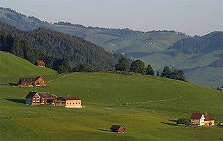
A landscape is the visible features of an area of land, its landforms, and how they integrate with natural or human-made features, often considered in terms of their aesthetic appeal. A landscape includes the physical elements of geophysically defined landforms such as mountains, hills, water bodies such as rivers, lakes, ponds and the sea, living elements of land cover including indigenous vegetation, human elements including different forms of land use, buildings, and structures, and transitory elements such as lighting and weather conditions. Combining both their physical origins and the cultural overlay of human presence, often created over millennia, landscapes reflect a living synthesis of people and place that is vital to local and national identity.

Anglo-Saxon architecture was a period in the history of architecture in England from the mid-5th century until the Norman Conquest of 1066. Anglo-Saxon secular buildings in Britain were generally simple, constructed mainly using timber with thatch for roofing. No universally accepted example survives above ground. Generally preferring not to settle within the old Roman cities, the Anglo-Saxons built small towns near their centres of agriculture, at fords in rivers or sited to serve as ports. In each town, a main hall was in the centre, provided with a central hearth.
Aerial archaeology is the study of archaeological remains by examining them from a higher altitude. In present day, this is usually achieved by satellite images or through the use of drones.
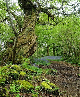
In the United Kingdom, ancient woodland is that which has existed continuously since 1600 in England, Wales and Northern Ireland. Planting of woodland was uncommon before those dates, so a wood present in 1600 is likely to have developed naturally.

In archaeology, survey or field survey is a type of field research by which archaeologists search for archaeological sites and collect information about the location, distribution and organization of past human cultures across a large area. Archaeologists conduct surveys to search for particular archaeological sites or kinds of sites, to detect patterns in the distribution of material culture over regions, to make generalizations or test hypotheses about past cultures, and to assess the risks that development projects will have adverse impacts on archaeological heritage.

Sub-Roman Britain is the period of late antiquity in Great Britain between the end of Roman rule and the Anglo-Saxon settlement. The term was originally used to describe archaeological remains found in 5th- and 6th-century AD sites that hinted at the decay of locally made wares from a previous higher standard under the Roman Empire. It is now used to describe the period that commenced with the recall of Roman troops to Gaul by Constantine III in 407 and to have concluded with the Battle of Deorham in 577.
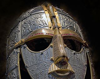
Anglo-Saxon paganism, sometimes termed Anglo-Saxon heathenism, Anglo-Saxon pre-Christian religion, Anglo-Saxon traditional religion, or Anglo-Saxon polytheism refers to the religious beliefs and practices followed by the Anglo-Saxons between the 5th and 8th centuries AD, during the initial period of Early Medieval England. A variant of Germanic paganism found across much of north-western Europe, it encompassed a heterogeneous variety of beliefs and cultic practices, with much regional variation.
Yeavering is a hamlet in the north-east corner of the civil parish of Kirknewton in the English county of Northumberland. It is located on the River Glen at the northern edge of the Cheviot Hills. It is noteworthy as the site of a large Anglo-Saxon period settlement that archaeologists have interpreted as being one of the seats of royal power held by the kings of Bernicia in the 7th century AD.
A dispersed settlement, also known as a scattered settlement, is one of the main types of settlement patterns used by landscape historians to classify rural settlements found in England and other parts of the world. Typically, there are a number of separate farmsteads scattered throughout the area. A dispersed settlement contrasts with a nucleated village. It can be known as main human settlements.
The study of field systems in landscape history is concerned with the size, shape and orientation of a number of fields. These are often adjacent, but may be separated by a later feature.
Boundaries—particularly field boundaries—are among the oldest features in an English rural landscape. Although a boundary itself is an abstract concept, the boundary can often be seen by differences in land use on either side.
Historic landscape characterisation is a programme initiated by English Heritage to increase understanding of the wider designed landscape, beyond that of the planned parkland of the country estate. Similar programmes operate in Scotland, Wales and the Republic of Ireland, although different terminology is used. In Catalonia, since 2010, there is the PaHisCat program.

In medieval and Early Modern England, Wales and Ireland, a deer park was an enclosed area containing deer. It was bounded by a ditch and bank with a wooden park pale on top of the bank, or by a stone or brick wall. The ditch was on the inside increasing the effective height. Some parks had deer "leaps", where there was an external ramp and the inner ditch was constructed on a grander scale, thus allowing deer to enter the park but preventing them from leaving.
Mucking is an archaeological site near the village of Mucking in southern Essex. The site contains remains dating from the Neolithic to the Middle Ages—a period of some 3,000 years—and the Bronze Age and Anglo-Saxon features are particularly notable.
The settlement of Great Britain by diverse Germanic peoples led to the development of a new Anglo-Saxon cultural identity and shared Germanic language, Old English, which was most closely related to Old Frisian on the other side of the North Sea. The first Germanic-speakers to settle permanently are likely to have been soldiers recruited by the Roman administration, possibly already in the fourth century or earlier. In the early fifth century, after the end of Roman rule in Britain and the breakdown of the Roman economy, larger numbers arrived and their impact upon local culture and politics increased.
Dominic Powlesland, is a British landscape archaeologist based in North Yorkshire. He has contributed to the methodologies of field archaeology and landscape survey, particularly geophysics and the use of computers when recording and processing archaeological data. He is the director of the Landscape Research Centre and visiting professor at the universities of York, Leeds, Huddersfield and Vienna.

The Making of the English Landscape is a 1954 book by the English local historian William George Hoskins. The book is also the introductory volume in a series of the same name which deals with the English Landscape county by county.
Regiones or provinciae,(singular: provincia), also referred to by historians as small shires or early folk territories, were early territorial divisions of Anglo-Saxon England, referred to in sources such as Anglo-Saxon charters and the writings of Bede. They are likely to have originated in the years before 600, and most evidence for them occurs in sources from or about the 7th century.