East of England

Last updated

East of England
Peterborough Cathedral Exterior.jpg
Colchester Castle (geograph 4444025).jpg
How Hill.jpg
StAlbansCathedral-PS02.JPG
Garden and west wing Hatfield House Hertfordshire England 2 DxO.jpg
Norwich, Elm Hill - geograph.org.uk - 4580260.jpg
Lady Street, Lavenham - geograph.org.uk - 4155996.jpg
King's College, Cambridge, in the snow 2.jpg
East of England in England.svg
East of England, highlighted in red on a beige political map of England
Coordinates: 52°14′N0°25′E / 52.24°N 0.41°E / 52.24; 0.41
Sovereign state United Kingdom
Country England
Combined authorities Cambridgeshire and Peterborough
Districts
Counties
Government
  Type Local authority leaders' board
  Body East of England Local Government Association
   House of Commons 58 MPs (of 650)
Area
[1]
  Total7,562 sq mi (19,585 km2)
  Land7,381 sq mi (19,116 km2)
  Water7 sq mi (17 km2)
  Rank 2nd
Population
 (2021) [2]
  Total6,348,096
  Rank 4th
  Density860/sq mi (332/km2)
Ethnicity (2021)
[3]
   Ethnic groups
List
Religion (2021)
[3]
   Religion
List
GSS code E12000006
ITL code TLH
GVA 2021 estimate [4]
 Total£171.4 billion
 Rank 4th
 Per capita£26,995
 Rank 3rd
GDP (nominal)2021 estimate [5]
 Total£193.3 billion
 Rank 4th
 Per capita£30,442
 Rank 3rd

The East of England is one of the nine official regions of England in the United Kingdom. This region was created in 1994 and was adopted for statistics purposes from 1999. It includes the ceremonial counties of Bedfordshire, Cambridgeshire, Essex, Hertfordshire, Norfolk and Suffolk. Essex has the highest population in the region. [6]

Contents

The population of the East of England region in 2018 was 6.24 million. [7] Bedford, Luton, Basildon, Peterborough, Southend-on-Sea, Norwich, Ipswich, Colchester, Chelmsford and Cambridge are the region's most populous settlements. [8] The southern part of the region lies in the London commuter belt.

Geography

England population density and low elevation coastal zones. East of England is particularly vulnerable to sea level rise. London, Great Britain Population Density and Low Elevation Coastal Zones (5457306673).jpg
England population density and low elevation coastal zones. East of England is particularly vulnerable to sea level rise.

The East of England region has the lowest elevation range in the UK. Twenty percent of the region is below mean sea level, most of this in North Cambridgeshire, Norfolk and on the Essex Coast. [9] [10] Most of the remaining area is of low elevation, with extensive glacial deposits. [11] The Fens, a large area of reclaimed marshland, are mostly in North Cambridgeshire. [12] The Fens include the lowest point in the country in the village of Holme: 2.75 metres (9.0 ft) below mean sea level. This area formerly included the body of open water known as Whittlesey Mere. The highest point in the region is at Clipper Down at 817 ft (249 m) above mean sea level, in the far southwestern corner of the region in the Ivinghoe Hills. [13] [14] [15]

Communities known as New Towns, responses to urban congestion and World War II destruction, appeared in Basildon and Harlow (Essex), as well as in Stevenage and Hemel Hempstead (Hertfordshire), in the 1950s and 1960s. [16] In the late 1960s, the Roskill Commission considered Cublington in Buckinghamshire, Thurleigh in Bedfordshire, Nuthampstead in Hertfordshire and Foulness in Essex as locations for a possible third airport for London. A new airport was not built, but a former Royal Air Force base at Stansted, which had previously been converted to civilian use redeveloped and expanded in the following decades. [17]

Historical use

The East of England succeeded the standard statistical region East Anglia (which excluded Essex, Hertfordshire and Bedfordshire, then in the South East). The East of England civil defence region was identical to today's region. [18]

East Anglia with Home Counties

Essex, despite meaning East-Saxons, previously formed part of South East England, along with Bedfordshire and Hertfordshire, a mixture of definite and debatable Home counties. The earliest use of the term is from 1695. Charles Davenant, in An essay upon ways and means of supplying the war, wrote, "The Eleven Home Counties, which are thought in Land Taxes to pay more than their proportion..." then cited a list including these four. The term does not appear to have been used in taxation since the 18th century. [19]

Climate

East Anglia is one of the driest parts of the United Kingdom, with average rainfall ranging from 450 to 750 mm (18 to 30 in). [20] The area receives such low rainfall amounts because low pressure systems and weather fronts from the Atlantic lose a lot of moisture over land (and therefore are usually much weaker) by the time they reach Eastern England. [21]

Winter (mid-November – mid-March) is mostly cool, but non-prevailing cold easterly winds can affect the area from the continent. These can bring heavy snowfall if the winds interact with a low-pressure system over the Atlantic or France. [21] Northerly winds also can be cold but are not usually as cold as easterly winds. Westerly winds bring milder and, typically, wetter weather. Southerly winds usually bring mild air (if from the Atlantic or North Africa) but chill if coming from further east than Spain. [22]

Spring (mid-March – May) is a transitional season that initially can be chilly but is usually warm by late-April/May. The weather at this time is often changeable (within each day) and occasionally showery. [23]

Summer (June – mid-September) is usually warm. Continental air from mainland Europe or the Azores High usually leads to at least a few weeks of hot, balmy weather with prolonged warm to hot temperatures. The number of summer storms from the Atlantic, such as the remnants of a tropical storm, usually coincides with the location of the jet stream. The East tends to receive much less rain than the other regions. [23]

Autumn (mid-September – mid-November) is usually mild with some days being very unsettled and rainy and others warm. At least part of September and early October in the East have warm and settled weather, but only in rare years is there an Indian summer where fine weather marks the entire traditional harvest season. [23]

Demographics

East of England population pyramid in 2020 East of England population pyramid 2020.svg
East of England population pyramid in 2020

Population

Ethnicity

Ethnic groupYear
1991 [24] 2001 [25] 2011 [26] 2021 [27]
Number%Number%Number%Number%
White: Total4,891,67596.8%5,125,00395.11%5,310,19490.81%5,478,36486.5%
White: British 4,927,34391.44%4,986,17085.27%4,972,14978.5%
White: Irish 61,20855,57357,9640.9%
White: Irish Traveller/Gypsy --8,1658,9770.1%
White: Roma9,6750.2%
White: Other 136,452260,286429,5996.8%
Asian or Asian British: Total99,7202%142,1372.63%278,3724.76%405,8696.5%
Asian or Asian British: Indian 39,29251,03586,736136,9742.2%
Asian or Asian British: Pakistani 24,71338,79066,27099,4521.6%
Asian or Asian British: Bangladeshi 10,93418,50332,99250,6850.8%
Asian or Asian British: Chinese 12,49420,38533,50338,4440.6%
Asian or Asian British: Asian Other 12,28713,42458,87180,3141.3%
Black or Black British: Total42,3100.8%48,4640.89%117,4422%184,9493%
Black or Black British: African 6,37316,96869,925118,7311.9%
Black or Black British: Caribbean 21,89226,19933,61441,8840.7%
Black or Black British: Other 14,0455,29713,90324,3340.4%
Mixed: Total57,9841.07%112,1161.91%179,6542.8%
Mixed: White and Caribbean 19,88237,22251,9500.8%
Mixed: White and African 6,10915,38827,3760.4%
Mixed: White and Asian 17,38532,22651,4480.8%
Mixed: Other Mixed 14,60827,28048,8800.8%
Other: Total21,8100.4%14,5520.27%28,8410.49%86,2321.3%
Other: Arab --10,36715,6390.2%
Other: Any other ethnic group21,8100.4%14,55218,47470,5931.1%
Total5,055,515100%5,388,140100%5,846,965100%6,335,068100%

Politics

Elections

General Election results in 2017 United Kingdom General Election 2017 Results Map (East of England).svg
General Election results in 2017

In the 2015 general election there was an overall swing of 0.25% from the Conservatives to Labour and the Liberal Democrats lost 16% of its vote. All of Hertfordshire and Suffolk is now Conservative. The region's electorate voted 49% Conservative, 22% Labour, 16% UKIP, 8% Liberal Democrat and 4% Green. Like other regions, the division of seats favours the dominant party in the region and the Conservatives had 52, Labour 4 (Cambridge, Luton South, Luton North and Norwich South), UKIP 1 (Clacton) and 1 Liberal Democrat (North Norfolk). [28]

Number of MPs returned per party, total 58
(situation at end of parliament in brackets)
Affiliation 2010–15 2015–17 2017–19 2019-present
Conservative Party 525250 (46)52
Liberal Democrats 411 (2)1
Labour Party 247 (5)5
The Independents 000 (1)0
Independent 010 (4)0

Governance and regions

East of England Plan

The East of England Plan, a revision of the Regional Spatial Strategy for the East of England, was published on 12 May 2008. It was revoked on 3 January 2013. [29]

Local government

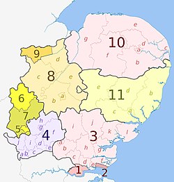
The official region consists of the following subdivisions:

MapCeremonial countyShire county / unitaryDistricts
East of England counties 2019 map.jpg Essex 1.  Thurrock U.A.
2.  Southend-on-Sea U.A.
3. Essexa)  Harlow, b)  Epping Forest, c)  Brentwood, d)  Basildon, e)  Castle Point, f)  Rochford, g)  Maldon, h)  Chelmsford, i)  Uttlesford, j)  Braintree, k)  Colchester, l)  Tendring
4.  Hertfordshire a)  Three Rivers, b)  Watford, c)  Hertsmere, d)  Welwyn Hatfield, e)  Broxbourne, f)  East Hertfordshire, g)  Stevenage, h)  North Hertfordshire, i)  St Albans, j)  Dacorum
Bedfordshire 5.  Luton U.A.
6.  Bedford U.A.
7.  Central Bedfordshire U.A.
Cambridgeshire 8. Cambridgeshirea)  Cambridge, b)  South Cambridgeshire, c)  Huntingdonshire, d)  Fenland, e)  East Cambridgeshire
9.  Peterborough U.A.
10.  Norfolk a)  Norwich, b)  South Norfolk, c)  Great Yarmouth, d)  Broadland, e)  North Norfolk, f)  Breckland, g)  King's Lynn and West Norfolk
11.  Suffolk a)  Ipswich, b) East Suffolk, c)  Babergh, d)  Mid Suffolk, e) West Suffolk

Eurostat NUTS

In the Eurostat Nomenclature of Territorial Units for Statistics (NUTS), the East of England was a level-1 NUTS region, coded "UKH", which was subdivided as follows:

NUTS 1CodeNUTS 2CodeNUTS 3Code
East of EnglandUKH East Anglia UKH1 Peterborough UKH11
NUTS 3 regions of the East of England 2010 map.svg Cambridgeshire CCUKH12
Norfolk UKH13
Suffolk UKH14
Bedfordshire and Hertfordshire UKH2 Luton UKH21
Hertfordshire CCUKH23
Bedford UKH24
Central Bedfordshire UKH25
Essex UKH3 Southend-on-Sea UKH31
Thurrock UKH32
Essex CCUKH33

After the UK's departure from the EU, the UK NUTS regions were renamed as International Territorial Level regions in 2021.

History

Civil War and the Protectorate

The East of England was a major force and resource for Parliament and, in particular, in the form of the Eastern Association. Oliver Cromwell came from Huntingdon. [30]

Second World War

Norfolk, Suffolk and Essex played host to the American VIII Bomber Command and Ninth Air Force. The Imperial War Museum at Duxford has an exhibition, commemorating their participation and sacrifice, near to the M11 south of Cambridge. [30]

Stansted Airport was RAF Stansted Mountfitchet, home to the 344th Bombardment Group. The de Havilland Mosquito was mainly assembled at Hatfield and Leavesden, although much of the innovative wooden structure originated outside the region from the furniture industry of High Wycombe; the Mosquito entered service in 1942 with 105 Sqn at RAF Horsham St Faith. RAF Tempsford in Bedford is the airfield from where SOE secret agents for Europe took off, with 138 Sqn which parachuted agents and equipment and 161 Sqn which landed and retrieved agents. 19 Sqn at Duxford was the first to be equipped with the Spitfire on 4 August 1938. [30]

Cold War

The 81st Tactical Fighter Wing was at RAF Bentwaters from January 1952 and also at RAF Woodbridge; in the late 1980s some of the aircraft went to RAF Alconbury. Alconbury closed in 1992 and Bentwaters closed in 1993, with the American air forces being in the area for 42 years; the USAF aircraft subsequently moved to Spangdahlem Air Base in Rhineland-Palatinate, Germany. [31]

At RAF Marham in west Norfolk, 214 Sqn with the Vickers Valiant developed the RAF's refuelling system; later the squadron would be equipped with the Handley Page Victor. Work on refuelling had also taken place at RAF Tarrant Rushton in Dorset. [31]

From the 1950s, RAF Wyton was an important reconnaissance base for the RAF, mainly 543 Sqn. The base is now home of the Defence Intelligence Fusion Centre, previously known as JARIC, or the Joint Air Reconnaissance Intelligence Centre from 1956. [31]

Healthcare

NHS East of England, which was the strategic health authority for the area until the abolition of these areas in 2013, is on Capital Park, next to Fulbourn Tesco, Fulbourn Hospital, and the Cambridge-Ipswich railway, on the eastern edge of Cambridge. The East of England Ambulance Service is on Cambourne Business Park on Cambourne, of the A428 (the former A45) west of Cambridge. The East Anglian Air Ambulance operates from Cambridge Airport and Norwich Airport; Essex Air Ambulance operates from Boreham. [32]

Economy

The former electricity company for the area, Eastern Electricity, has the area's distribution now looked after by UK Power Networks at Fore Hamlet in Ipswich. UK Power Networks also looks after London and most of the South-East. Business Link in the East of England is near to the headquarters of Ocado in Hatfield, at the roundabout of the A1057 and the A1001 on the Bishops Square Business Park. [33] [34] The region's Manufacturing Advisory Service is at Melbourn in Cambridgeshire, off the A10 and north of Royston. [35] UK Trade & Investment for the region is in Histon [36] with its international trade team based next to Magdalene College.

Hertfordshire

Wetherspoons is based in Watford near Watford Junction railway station WetherspoonsPboro.jpg
Wetherspoons is based in Watford near Watford Junction railway station

The Greater Watford area is home to British Waterways, Vinci (which bought Taylor Woodrow in 2008), the UK of the international firm Total Oil, retailers TK Maxx, Bathstore, Majestic Wine, Mothercare, Costco and Smiths Detection, Iveco, BrightHouse (at Abbots Langley), Leavesden Film Studios, Sanyo, Europcar, Olympus, Kenwood and Beko electronic goods manufacturers, Wetherspoons pub chains, the European HQ of the Hilton hotel group and Nestlé Waters; in Garston is the UK headquarters of the Seventh-day Adventist Church, on the A412 and the Building Research Establishment. Comet Group and Camelot Group (owners of the National Lottery), on the A4145, are in Rickmansworth. Ferrero (maker of Nutella and Kinder Chocolate) is in Croxley Green. Renault and Skanska (construction) are in Maple Cross. [37]

Bedfordshire

Samuel Whitbread began his brewery in Bedfordshire in 1742 Samuel whitbread 1720-1796 by joshua reynolds.jpg
Samuel Whitbread began his brewery in Bedfordshire in 1742

Moto Hospitality has its headquarters at Toddington in Bedfordshire (at the Toddington services).

Luton is home to EasyJet,(based at the airport), Hain Celestial Group (which makes Linda McCartney Foods and is based on the B579 in Biscot), Eurolines (UK office), Thomson Holidays (based at Wigmore on the eastern edge of the town) and Chevrolet (at Griffin House, the Vauxhall head office). At the 85-acre Capability Green off the A1081 and junction 10a of the M1, is the Stonegate Pub Company (owner of Scream Pubs, Yates's, Slug and Lettuce and Hogshead), InBev UK (which bought most of Whitbread's beer brands), Chargemaster (electric vehicle network under the POLAR brand), AstraZeneca's UK Marketing Company division and Alexon Group (ladies clothing). Vauxhall produced its last Vauxhall Vectra in March 2002 at the plant near the A6/A505 roundabout, and now makes vans (Vivaro/Renault Trafic) at the former Bedford Vehicles plant, based in the north of the town at the GM Manufacturing Luton plant. [38]

East Anglia

Flag of East Anglia Flag of East Anglia.svg
Flag of East Anglia
Great Witchingham Hall, the headquarters of Bernard Matthews Farms, north-west of Norwich at Great Witchingham on the A1067 Great Witchingham Hall - geograph.org.uk - 73615.jpg
Great Witchingham Hall, the headquarters of Bernard Matthews Farms, north-west of Norwich at Great Witchingham on the A1067

The economy in Norfolk, Cambridgeshire and Suffolk is traditionally mostly agricultural. Norfolk is the UK's biggest producer of potatoes. Nationally known companies include the RAC, Archant (publishing), Virgin Money and Aviva (formerly Norwich Union) in Norwich. In Carrow, to the east of the city, Colman's makes a wide range of mustards, and Britvic makes Robinsons squash, which was owned by Colman's until 1995. Across the River Yare near the A47/A146 junction in Trowse with Newton is May Gurney, the construction company. Bernard Matthews Farms has a large turkey farm on the former RAF Attlebridge in Weston Longville. Campbell Soup was made in Kings Lynn until 2008, and on the Hardwick Industrial Estate at the A47/A149 junction is PinguinLutosa the UK, which packs frozen vegetables, and Caithness Crystal. [39]

Foster Refrigerator is the UK's leading manufacturer of commercial refrigerators and blast chillers, owned by Illinois Tool Works, based on the industrial estate; with Multitone Electronics, which has a manufacturing plant there, and which invented the pager in 1956, for St Thomas' Hospital; and Snap-on Diagnostics makes diagnostic tools for garages. British Sugar's Wissington is the world's largest sugar beet factory in Methwold, on the B1160 near the River Wissey. Lotus Cars and Team Lotus are on the eastern edge of the former RAF Hethel, east of Wymondham (A11) at Hethel (Bracon Ash). Jeyes Group makes household chemicals in Thetford, off the A134; Multiyork makes furniture and Baxter Healthcare has a manufacturing plant in the south of the town. Aunt Bessie vegetable products (roast potatoes) are made by Heinz at Westwick, in a factory built by Ross Group. [40]

ARM CPU designed in Cambridge P60ARM GC 01.jpg
ARM CPU designed in Cambridge

Around Cambridge on numerous science parks, are high technology (electronics and biochemistry) companies, such as ARM Holdings on Peterhouse Technology Park in the south-east of the town, Adder Technology (KVM switches) at Bar Hill at the A14/B1050 junction north of the town, Monsanto, Play.com on the Cambridge Business Centre. The Wellcome Trust Genome Campus has the European Bioinformatics Institute at Hinxton east of Duxford near the M11 spur for the A11. These form the so-called Silicon Fen. Marshall Aerospace is at Cambridge Airport on the A1303 in the east of the town, towards Teversham. South of the airport, Carl Zeiss NTS makes scanning electron microscopes in Cherry Hinton. Syngenta is to the east of Cambridge, on Capital Park at Fulbourn. Premier Foods has a large plant in Histon making Robertson's and Hartley's jam, Gale's honey, Smash instant potato, and Rose's marmalade. Addenbrooke's Hospital is a pioneering hospital in the UK, based at Cambridge Biomedical Campus. [41]

Universities

The most famous university in the region is the University of Cambridge. [42] The university has been officially rated as the best in the world in 2010. [43] It has the second-best medicine course in the world, and in 2010 became the only university outside of the US to raise over £1 billion in charitable donations.

There are eight universities in the region. Cambridge hosts two universities: the University of Cambridge and Anglia Ruskin University. It is also the home of the Open University's East of England branch. Norwich also hosts two universities: the University of East Anglia and Norwich University of the Arts. There are also other towns and cities in the region which have universities including Bedford and Luton (University of Bedfordshire), Colchester (University of Essex) and Hatfield (University of Hertfordshire). Other higher education centres in the region include University Centre Peterborough, University of Suffolk and Writtle College. [44]

.

University of Essex near Colchester University of Essex.jpg
University of Essex near Colchester

The University of Cambridge receives almost three times as much funding as any other university in the region, due to its huge research grant—the largest in England (and the UK). The next largest, by funding, is UEA in Norwich. The University of Essex and Cranfield University also have moderately large research grants, but no other universities in the region do. The largest university by student numbers is ARU, and the next biggest is Cambridge. The smallest is Essex. [44]

For total income to universities, Cambridge receives around £1 billion—around six times larger than any other university in the region. The University of Bedfordshire receives the least income. Cambridge has the lowest drop-out (discontinuation) rate in the region. Once graduated, over 50% of students stay in the region, with 25% going to London and 10% going to the South East. Very few go elsewhere—especially the North of England. [44]

Sport

Football

During the nineteenth century, several formulations of the laws of football, known as the Cambridge rules, were created by students at the University. One of these codes, dating from 1863, had a significant influence on the creation of the original laws of The Football Association. [45]

East of England's top representatives in the English football league system today are Ipswich Town, Norwich City, Watford and Luton Town, who have competed in the top flight at various points. Alongside teams Peterborough United, and Cambridge United. [46]

Literature

Children's author Dodie Smith lived near to the town of Sudbury in Suffolk, and part of her famous novel The Hundred and One Dalmatians which inspired the Disney animated film of the same name takes place in the town at St Peter's Church. [47]

Media

Television

Much of the region receives the BBC East and ITV Anglia television services, both based in Norwich (the BBC moving from All Saints' Green to The Forum in 2003, and Anglia remaining at its original base, Angia House.) These services broadcast from the Sandy Heath, Sudbury and Tacolneston transmitter groups. Some areas in close proximity to London, including Luton and south Essex, may receive their service from BBC London and ITV London; in addition, the Hemel Hempstead relay transmitter is a relay of the London services from Crystal Palace, bringing London television into parts of Hertfordshire. Northwestern parts of Norfolk including Kings Lynn receive a better TV signal from the Belmont transmitter that broadcast BBC East Yorkshire and Lincolnshire and ITV Calendar. Some editions of Look East and ITV News Anglia broadcast split news programming for the West (Home Counties) and East (East Anglia/Essex) of the region, with the West subregions broadcasting from Sandy Heath; the BBC's Western opt-outs are broadcast from studios in Cambridge, also the base of BBC Radio Cambridgeshire, whilst both versions of the ITV Anglia output have broadcast from Anglia House in Norwich since the split service was introduced in 1990. [48]

Radio

See also

Lists

Related Research Articles

<span class="mw-page-title-main">Cambridgeshire</span> County of England

Cambridgeshire is a ceremonial county in the East of England and East Anglia. It is bordered by Lincolnshire to the north, Norfolk to the north-east, Suffolk to the east, Essex and Hertfordshire to the south, and Bedfordshire and Northamptonshire to the west. The largest settlement is the city of Peterborough, and the city of Cambridge is the county town.

<span class="mw-page-title-main">East Anglia</span> Region of England

East Anglia is an area in the East of England. It comprises the counties of Norfolk and Suffolk, with Cambridgeshire and Essex also included in some definitions. The name derives from the Anglo-Saxon kingdom of the East Angles, a people whose name originated in Anglia, in what is now Northern Germany.

<i>BBC Look East</i> BBC television news programme for the East of England

BBC Look East is a BBC regional television news programmes for the East of England made by BBC East.

<span class="mw-page-title-main">Cambridgeshire Constabulary</span> English territorial police force

Cambridgeshire Constabulary is the local territorial police force that covers the county of Cambridgeshire and Peterborough unitary authority. It provides law enforcement and security for an area of 1,311 square miles (3,400 km2) and population of 856,000 people, in a predominantly rural county. The force of Cambridgeshire includes the cities of Cambridge, Ely and Peterborough, the market towns of Chatteris, Huntingdon, March, Ramsey, St Ives, St Neots, Whittlesey, and town and Port of Wisbech. Its emblem is a crowned Brunswick star containing the heraldic badge of Cambridgeshire County Council.

England is divided by a number of different regional schemes for various purposes. Since the creation of the Government Office Regions in 1994 and their adoption for statistical purposes in 1999, some historical regional schemes have become obsolete. However, many alternative regional designations also exist and continue to be widely used.

<i>About Anglia</i> English TV series or programme

About Anglia was a regional news magazine programme produced by Anglia Television in the east of England, broadcast for over thirty years from 2 June 1960 to 6 July 1990.

<span class="mw-page-title-main">BBC East</span>

BBC East is one of BBC's English Regions covering Norfolk, Suffolk, Essex, Cambridgeshire, Northamptonshire, Bedfordshire and parts of Hertfordshire and Buckinghamshire. It is headquartered in The Forum, Norwich since 2003. It was also separated into two areas, one with the East area covering mostly in Norfolk, Suffolk & Essex, and another from the West area which covers from Cambridge, serving mostly Cambridgeshire, Northamptonshire and the three counties.

Girlguiding Anglia is one of the nine Countries and Regions of Girlguiding UK. It is further subdivided into twelve Girlguiding Counties. These are not the same as the counties defined by the British government.

<span class="mw-page-title-main">Kingdom of East Anglia</span> Anglo-Saxon kingdom in southeast Britain

The Kingdom of the East Angles, informally known as the Kingdom of East Anglia, was a small independent kingdom of the Angles during the Anglo-Saxon period comprising what are now the English counties of Norfolk and Suffolk and perhaps the eastern part of the Fens, the area still known as East Anglia.

<span class="mw-page-title-main">East Anglian Air Ambulance</span> English air ambulance charity

The East Anglian Air Ambulance (EAAA) is an air ambulance providing Helicopter Emergency Medical Services (HEMS) across the English counties of Norfolk, Suffolk, Cambridgeshire and Bedfordshire. The appeal to fund the service was launched in the summer of 2000 by top jockey Frankie Dettori, who had been a casualty in a serious plane crash a couple of months earlier. When flying commenced in January 2001, the service was initially available only one day a week. The East Anglian Air Ambulance operates two helicopters, 365 days a year, from its bases at Cambridge Airport and Norwich Airport, covering over 5,000 square miles (13,000 km2) and a population of approximately 3.5 million.

<span class="mw-page-title-main">Scouting in East of England</span>

Scouting in East of England is about Scouting in the official region of East of England. It is largely represented by The Scout Association of the United Kingdom and some Groups of traditional Scouting including the Baden-Powell Scouts' Association.

Autism Anglia is an organisation and registered charity that provides services to those affected by autism in Essex, Suffolk, Norfolk and Cambridge. It began life in 1973 when Anthony Boobier discovered there were no specialist autism services for his newly diagnosed son. Its first establishment opened in 1977 and it opened adult services in 1983 when the original children grew up and it was realised that there was no specialised adult autism provision for them. In 2008, The Essex Autistic Society took over the Norfolk Autistic Community Housing Association and the Norfolk Autistic Society and changed the name of the new charity to Autism Anglia to better reflect the enlarged area of operation. In 2013 Autism Anglia took over the Cambridge-based charity East Anglian Autistic Support Trust (EAST).

The East of England Local Government Association (EELGA) is an association of the 52 local authorities in the East of England. It is a regional grouping of the Local Government Association and the regional employers organisation. It was established in April 2010 following the abolition of the East of England Regional Assembly.

<span class="mw-page-title-main">Transport in East Anglia</span>

Transport in East Anglia consists of extensive road and rail networks as well as one of England's key regional airports and the country's busiest container port. Despite having very little motorway within their borders, the counties of Suffolk, Norfolk and Cambridgeshire have modern transport links with the rest of the country.

<span class="mw-page-title-main">Kiss 105-108</span> Radio station in London

Kiss 105-108 was an Independent Local Radio station serving East Anglia from the Kiss Network. All programming after 2010 was networked from the national station KISS.

<span class="mw-page-title-main">Heart East</span> Regional radio station in Milton Keynes, England

Heart East is a regional radio station owned and operated by Global as part of the Heart network. It broadcasts to the East of England from studios in Milton Keynes.

<span class="mw-page-title-main">6th (Volunteer) Battalion, Royal Anglian Regiment</span> Military unit

The 6th (Volunteer) Battalion, Royal Anglian Regiment was a part-time infantry unit of the British Army part of the Territorial Army (TA). Originally formed in 1971 from the expansion of many cadres, the battalion would eventually be disbanded in 1999 and formed sub-units in the new East of England Regiment. Today, the battalion's successors still form part of the Army Reserve (AR) component of the Royal Anglian Regiment's only remaining reserve unit, the 3rd (V) Bn.

References

  1. "Standard Area Measurements (Latest) for Administrative Areas in the United Kingdom (V2)". Open Geography Portal. Office for National Statistics. 5 April 2023. Retrieved 3 December 2023.
  2. Park, Neil (21 December 2022). "Estimates of the population for the UK, England, Wales, Scotland and Northern Ireland". Office for National Statistics. Retrieved 25 August 2023.
  3. 1 2 UK Census (2021). "2021 Census Area Profile – East Region (E12000006)". Nomis. Office for National Statistics . Retrieved 14 August 2023.
  4. Fenton, Trevor (25 April 2023). "Regional gross value added (balanced) per head and income components". Office for National Statistics. Retrieved 14 August 2023.
  5. Fenton, Trevor (25 April 2023). "Regional gross domestic product: all ITL regions". Office for National Statistics. Retrieved 15 August 2023.
  6. "UK: county population". Statista. Retrieved 5 August 2020.
  7. "England: region population 2018". Statista. Retrieved 31 March 2021.
  8. "East of England (United Kingdom): Counties and Unitary Districts & Settlements - Population Statistics, Charts and Map". www.citypopulation.de. Retrieved 5 August 2020.
  9. "A Summary of Climate Change To coincide with the publication of the UK Climate Change Risk Assessment (CCRA) 2012 Risks for the East of England" (PDF). Retrieved 22 August 2020.
  10. "Norfolk topographic map, elevation, relief". topographic-map.com. Retrieved 22 August 2020.
  11. "East Anglia | region, England, United Kingdom". Encyclopedia Britannica. Retrieved 5 August 2020.
  12. "Fens | marshland, England, United Kingdom". Encyclopedia Britannica. Retrieved 5 August 2020.
  13. "Holme Fen | The Great Fen". www.greatfen.org.uk. Retrieved 5 August 2020.
  14. "Whittlesey Mere | The Great Fen". www.greatfen.org.uk. Retrieved 5 August 2020.
  15. Ltd, Copyright The mountain Guide-A.-Connect. "Clipper Down | England". UK mountain Guide. Archived from the original on 29 October 2020. Retrieved 5 August 2020.
  16. "Celebrating 70 Years of the New Towns Act". Town and Country Planning Association. Retrieved 25 August 2020.
  17. Roskill Commission on the Third London Airport.
  18. Haslam, Jeremy (January 2011). "Daws Castle, Somerset, and Civil Defence Measures in Southern and Midland England in the Ninth to Eleventh Centuries". Archaeological Journal. 168 (1): 195–226. doi:10.1080/00665983.2011.11020834. ISSN   0066-5983. S2CID   161250564.
  19. Home counties#In official use
  20. "UK climate - Weather and climate - GCSE Geography Revision". BBC Bitesize. Retrieved 31 March 2021.
  21. 1 2 Coombes, E. G.; Jones, A. P.; Bateman, I. J.; Tratalos, J. A.; Gill, J. A.; Showler, D. A.; Watkinson, A. R.; Sutherland, W. J. (21 January 2009). "Spatial and Temporal Modeling of Beach Use: A Case Study of East Anglia, UK". Coastal Management. 37 (1): 94–115. Bibcode:2009CoasM..37...94C. doi:10.1080/08920750802527127. ISSN   0892-0753. S2CID   153499701.
  22. Met, Office (2016). "Eastern England: climate". UK regional climates. Archived from the original on 9 July 2019. Retrieved 1 April 2021.
  23. 1 2 3 Dessai, Suraje; Hulme, Mike (February 2007). "Assessing the robustness of adaptation decisions to climate change uncertainties: A case study on water resources management in the East of England". Global Environmental Change. 17 (1): 59–72. doi:10.1016/j.gloenvcha.2006.11.005.
  24. Data is taken from United Kingdom Casweb Data services of the United Kingdom 1991 Census on Ethnic Data for England (Table 6)
  25. "Office of National Statistics; 2001 Census Key Statistics". webarchive.nationalarchives.gov.uk. Retrieved 24 June 2022.
  26. "2011 Census: Ethnic Group, local authorities in England and Wales". webarchive.nationalarchives.gov.uk. Retrieved 24 June 2022.
  27. "Ethnic group - Office for National Statistics". www.ons.gov.uk. Retrieved 29 November 2022.
  28. "UK Referendums 1997-98", British Elections & Parties Review, Routledge, pp. 267–272, 12 May 2014, doi:10.4324/9781315039664-13, ISBN   978-1-315-03966-4 , retrieved 23 March 2022
  29. "The East of England Plan, the Revision to the Regional Spatial Strategy for the East of England, has been published today (12 May 2008)". Go East. Archived from the original on 1 November 2008. Retrieved 13 November 2008.
  30. 1 2 3 Macleod, Jenny (October 2013). "Britishness and Commemoration: National Memorials to the First World War in Britain and Ireland". Journal of Contemporary History. 48 (4): 647–665. doi:10.1177/0022009413493940. ISSN   0022-0094. S2CID   159751130.
  31. 1 2 3 Major, Patrick; Mitter, Rana (October 2003). "East is East and West is West? Towards a comparative socio-cultural history of the Cold War". Cold War History. 4 (1): 1–22. doi:10.1080/14682740312331391714. ISSN   1468-2745. S2CID   154674169.
  32. Hernandez, Donald J. (2004). "Demographic Change and the Life Circumstances of Immigrant Families". The Future of Children. 14 (2): 17–47. doi:10.2307/1602792. JSTOR   1602792.
  33. "Business Link". Archived from the original on 3 April 2011.
  34. "Business Map East". Archived from the original on 16 May 2017. Retrieved 30 May 2015.
  35. MAS East Archived 26 August 2011 at the Wayback Machine
  36. "UK Trade & Investment – GOV.UK". Archived from the original on 9 January 2014. Retrieved 30 May 2015.
  37. Archer, Ian W (12 June 2019). "Almshouses in Early Modern England: Charitable Housing in the Mixed Economy of Welfare, 1550–1725, by Angela Nicholls". The English Historical Review. 134 (567): 458–459. doi:10.1093/ehr/cez023. ISSN   0013-8266.
  38. Archer, Ian W (12 June 2019). "Almshouses in Early Modern England: Charitable Housing in the Mixed Economy of Welfare, 1550–1725, by Angela Nicholls". The English Historical Review. 134 (567): 458–459. doi:10.1093/ehr/cez023. ISSN   0013-8266.
  39. Archer, Ian W (12 June 2019). "Almshouses in Early Modern England: Charitable Housing in the Mixed Economy of Welfare, 1550–1725, by Angela Nicholls". The English Historical Review. 134 (567): 458–459. doi:10.1093/ehr/cez023. ISSN   0013-8266.
  40. Archer, Ian W (12 June 2019). "Almshouses in Early Modern England: Charitable Housing in the Mixed Economy of Welfare, 1550–1725, by Angela Nicholls". The English Historical Review. 134 (567): 458–459. doi:10.1093/ehr/cez023. ISSN   0013-8266.
  41. Archer, Ian W (12 June 2019). "Almshouses in Early Modern England: Charitable Housing in the Mixed Economy of Welfare, 1550–1725, by Angela Nicholls". The English Historical Review. 134 (567): 458–459. doi:10.1093/ehr/cez023. ISSN   0013-8266.
  42. Archives, The National. "The National Archives – UK Government Web Archive". www.nationalarchives.gov.uk. Archived from the original on 18 September 2018. Retrieved 23 May 2019.
  43. Jeevan Vasagar (8 September 2010). "The world's top 100 universities, 2010". The Guardian. Archived from the original on 30 May 2015. Retrieved 30 May 2015.
  44. 1 2 3 Winters, Jane (7 March 2019), "Negotiating the archives of UK web space", The Historical Web and Digital Humanities, Abingdon, Oxon: Routledge, pp. 75–88, doi:10.4324/9781315231662-6, ISBN   9781315231662, S2CID   149676241 , retrieved 24 March 2022
  45. Harvey, Adrian (2005). Football: the First Hundred Years. London: Routledge. pp. 144–5. ISBN   0-415-35019-0. Archived from the original on 1 May 2017. Retrieved 3 July 2019.
  46. Harvey, Adrian (2005). Football, the first hundred years : the untold story. London: Routledge. ISBN   0-203-02315-3. OCLC   252707881.
  47. "101 Dalmatians and Sudbury". www.visitchurches.org.uk.
  48. "East Meets North East : Japan in the Local Community", Japan and the North East of England : From 1862 to the Present Day, Bloomsbury Academic, 1989, doi:10.5040/9781472553386.ch-007, ISBN   978-1-4725-5338-6 , retrieved 24 March 2022
  49. Berry, Richard (1 April 2020). "Radio, music, podcasts ‐ BBC Sounds: Public service radio and podcasts in a platform world". Radio Journal:International Studies in Broadcast & Audio Media. 18 (1): 63–78. doi:10.1386/rjao_00016_1. ISSN   1476-4504. S2CID   225962762.