Babergh District

Last updated • 4 min readFrom Wikipedia, The Free Encyclopedia

52°02′53″N0°56′53″E / 52.048°N 0.948°E / 52.048; 0.948

Contents

Babergh District
Friars Street, Sudbury - geograph.org.uk - 2736302.jpg
Sudbury, the district's largest town
Babergh UK locator map.svg
Babergh shown within Suffolk
Sovereign state United Kingdom
Constituent country England
Region East of England
Non-metropolitan county Suffolk
Status Non-metropolitan district
Admin HQ Ipswich
Incorporated1 April 1974
Government
  TypeNon-metropolitan district council
  BodyBabergh District Council
   MPs James Cartlidge
Area
  Total229.8 sq mi (595.2 km2)
  Rank60th (of 296)
Population
 (Census 2021)
  Total92,300
  Rank255th (of 296)
  Density400/sq mi (160/km2)
Ethnicity (2021)
[1]
   Ethnic groups
List
Religion (2021)
[1]
   Religion
List
Time zone UTC0 (GMT)
  Summer (DST) UTC+1 (BST)
ONS code 42UB (ONS)
E07000200 (GSS)
OS grid reference TM021429

Babergh District (pronounced /ˈbbə/ , BAY-bə [2] ) is a local government district in Suffolk, England. In 2021 it had a population of 92,300. The district is primarily a rural area, containing just two towns, Sudbury and Hadleigh, which was the administrative centre until 2017 when the council moved to shared offices with neighbouring Mid Suffolk District Council in Ipswich, outside either district. [3] [4] [5] The district is named after the medieval Babergh Hundred, which covered part of the area.

The district includes parts of two designated Areas of Outstanding Natural Beauty, Dedham Vale, known for its association with painter John Constable, and Suffolk Coast and Heaths.

The neighbouring districts are East Suffolk, Ipswich, Mid Suffolk, West Suffolk, Braintree, Colchester and Tendring.

History

The district was created on 1 April 1974 under the Local Government Act 1972, covering five former districts which were all abolished at the same time:

Samford Rural District had been in the administrative county of East Suffolk prior to the reforms; the other districts had all been in West Suffolk. [6]

The new district was named Babergh after the medieval hundred of Babergh, which had covered part of the area. [7] Babergh Hundred is referred to in the Domesday Book of 1086; the modern district covers a larger area than the historic hundred, also covering the hundreds of Cosford and Samford. The council's logo now says "Babergh District Council – South Suffolk".

Governance

Babergh District Council
Babergh District Council logo.png
Type
Type
Leadership
Elisabeth Malvisi,
Independent
since 23 May 2023 [8]
Deborah Saw,
Green
since 20 May 2024 [9]
Arthur Charvonia
since 2017 [10]
Structure
Seats32 councillors
Babergh District Council.svg
Political groups
Administration (24)
  Green (10)
  Independent (9)
  Liberal Democrats (5)
Other parties (8)
  Conservative (7)
  Labour (1)
Elections
First past the post
Last election
4 May 2023
Next election
6 May 2027
Meeting place
Endeavour House, home of Suffolk County Council - geograph.org.uk - 1305044.jpg
Endeavour House, 8 Russell Road, Ipswich, IP1 2BX
Website
www.babergh.gov.uk

Babergh District Council provides district-level services. County-level services are provided by Suffolk County Council. [11] The whole district is also covered by civil parishes, which form a third tier of local government. [12]

In 2011, Babergh and Mid Suffolk District Councils began working together, with one, fully integrated staff structure. [13]

Political control

The council has been under no overall control since the 2019 election. Following the 2023 election a coalition of the Greens, independents and Liberal Democrats formed to run the council. [14]

The first elections were held in 1973, initially operating as a shadow authority alongside the outgoing authorities until the new arrangements came into effect on 1 April 1974. Political control of the council since 1974 has been as follows: [15] [16]

Party in controlYears
No overall control 1974–2015
Conservative 2015–2019
No overall control 2019–present

Leadership

Prior to 2014 there was no formal position of leader of the council at Babergh, with political leadership provided instead by the chair of the policy and resources committee, or its successor, the strategy committee. [17] From 2014 onwards, the chair of the strategy committee was also given the title of leader. [18] The council then moved from a committee system to a leader and cabinet model in 2017, giving the leader additional powers to make executive decisions. [19] The leaders (or chairs of policy and resources / strategy committees) since 1998 have been: [20]

CouncillorPartyFromTo
Colin Spence Conservative 19982003
Sue Carpendale Liberal Democrats 20032005
Nick Ridley [21] Conservative 20052011
Jennie Jenkins [22] Conservative 19 May 201119 Dec 2017
John Ward [23] Conservative 4 Jan 201825 Apr 2022
Independent 25 Apr 202223 May 2023
David Busby Liberal Democrats 23 May 202320 May 2024
Deborah Saw Green 20 May 2024

Composition

Following the 2023 election, the composition of the council was: [24]

PartyCouncillors
Green 10
Independent 9
Conservative 7
Liberal Democrats 5
Labour 1
Total32

The next election is due in 2027.

Elections

Since the last boundary changes in 2019 the council has comprised 32 councillors representing 24 wards, with each ward electing one, two or three councillors. Elections are held every four years. [25]

Premises

Since 2017 Babergh and Mid Suffolk councils have their combined headquarters at Endeavour House in Ipswich, sharing the building with Suffolk County Council. [26]

Council Offices, Corks Lane, Hadleigh: Council's headquarters 1982-2017. Part of the Babergh District Council Offices, Hadleigh - geograph.org.uk - 4859252.jpg
Council Offices, Corks Lane, Hadleigh: Council's headquarters 1982–2017.

When the council was first created it inherited offices in Sudbury, Hadleigh and Ipswich from its predecessor councils. The council initially based itself at the former Cosford Rural District Council's offices at 32 High Street in Hadleigh. [27] [28] The council built itself a new headquarters on Corks Lane in Hadleigh, incorporating existing cottages and granaries into the new building. The new complex was formally opened on 4 June 1982. [29]

Geography

Foreshore at Shotley Gate at the eastern tip of the district. Foreshore at Shotley Gate - geograph.org.uk - 1247909.jpg
Foreshore at Shotley Gate at the eastern tip of the district.

The southern boundary of the district is marked almost exclusively by the River Stour, which also forms the border with Essex, and it is separated from East Suffolk by the River Orwell. The eastern part of the district forms a peninsula between the two tidal rivers, coming to a point at Shotley Gate.

Willy Lott's Cottage at Flatford, noted for being depicted in several paintings by John Constable, including The Hay Wain. The scene for The Hay Wain - geograph.org.uk - 4134596.jpg
Willy Lott's Cottage at Flatford, noted for being depicted in several paintings by John Constable, including The Hay Wain .

'Constable Country' is cognate with a large tract of Babergh: drawing visitors to the Dedham Vale, a designated Area of Outstanding Natural Beauty, and the well-preserved villages of Long Melford, Lavenham and Kersey. The district also includes part of the built-up area of Ipswich at Pinewood.

Demography

Babergh's population size has increased by 5.2%, from around 87,700 in 2011 to 92,300 in 2021 [30] and covers an area of approximately 230 square miles (600 km2). [31]

Towns and parishes

Hadleigh, the district's other town. Hadleigh Church - geograph.org.uk - 86057.jpg
Hadleigh, the district's other town.
Lavenham, one of the district's many villages. Lavenham High Street.jpg
Lavenham, one of the district's many villages.

The whole district is covered by civil parishes. The parish councils for Sudbury and Hadleigh have declared their parishes to be towns, allowing them to take the style "town council". Some of the smaller parishes have a parish meeting rather than a parish council. [32]

Related Research Articles

<span class="mw-page-title-main">Hadleigh, Suffolk</span> Human settlement in England

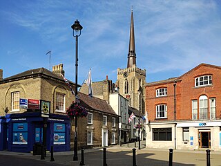
Hadleigh is an ancient market town and civil parish in the Babergh district of Suffolk, England. The town is situated next to the River Brett, between the larger towns of Sudbury and Ipswich. It had a population of 8,253 at the 2011 census. The headquarters of Babergh District Council were located in the town until 2017.

<span class="mw-page-title-main">Tendring District</span> Non-metropolitan district in England

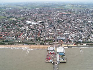
Tendring District is a local government district in north-east Essex, England. Its council is based in Clacton-on-Sea, the largest town. Other towns are Brightlingsea, Harwich, Frinton-on-Sea and Walton-on-the-Naze.

<span class="mw-page-title-main">Mid Suffolk</span> Non-metropolitan district in England

Mid Suffolk is a local government district in Suffolk, England. The district is primarily a rural area, containing just three towns, being Stowmarket, Needham Market and Eye. Its council was based in Needham Market until 2017 when it moved to shared offices with neighbouring Babergh District Council in Ipswich, outside either district. In 2021 it had a population of 103,417.

<span class="mw-page-title-main">West Suffolk (county)</span> English administrative county (1889–1974)

West Suffolk was an administrative county of England created in 1889 from part of the county of Suffolk. It survived until 1974 when it was rejoined with East Suffolk. Its county town was Bury St Edmunds.

<span class="mw-page-title-main">South Suffolk (UK Parliament constituency)</span> Parliamentary constituency in the United Kingdom, 1983 onwards

South Suffolk is a constituency represented in the House of Commons of the UK Parliament since 2015 by James Cartlidge, a Conservative.

<span class="mw-page-title-main">Boxford, Suffolk</span> Human settlement in England

Boxford is a village and civil parish in the Babergh district of Suffolk, England. Located around six miles east of Sudbury straddling the River Box and skirted by the Holbrook. The parish includes the hamlets of Calais Street, Hagmore Green and Stone Street. In 2021 the built-up area had a population of 833. In 2021 the parish had a population of 1403. The parish borders Assington, Edwardstone, Groton, Kersey, Newton and Polstead. There are 87 listed buildings in Boxford. Boxford became a conservation area in 1973.

<span class="mw-page-title-main">Suffolk County Council</span> Governmental body in England

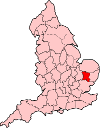
Suffolk County Council is the upper-tier local authority for the county of Suffolk, England. It is run by 75 elected county councillors representing 63 divisions. It is a member of the East of England Local Government Association.

Sudbury and Woodbridge was a county constituency centred on the towns of Sudbury and Woodbridge in Suffolk. It returned one Member of Parliament (MP) to the House of Commons of the Parliament of the United Kingdom.

<span class="mw-page-title-main">2005 Suffolk County Council election</span> 2005 UK local government election

Elections to Suffolk County Council were held on 5 May 2005. The whole council was up for election with boundary changes since the last election in 2001 reducing the number of seats by 5. The Conservative Party gained control of the council from no overall control.

<span class="mw-page-title-main">Edwardstone</span> Human settlement in England

Edwardstone is a village and civil parish in the Babergh district, in the county of Suffolk, England. The parish contains the hamlets of Mill Green, Priory Green, Round Maple and Sherbourne Street, and Edwardstone Woods, a Site of Special Scientific Interest. In 2021 the parish had a population of 375. The parish boarders Boxford, Great Waldingfield, Groton, Little Waldingfield, Milden and Newton.

<span class="mw-page-title-main">Groton, Suffolk</span> Human settlement in England

Groton is a village and civil parish in the Babergh district, Suffolk, England, located around a mile north of the A1071 between Hadleigh and Sudbury. In 2021 the parish had a population of 299.

<span class="mw-page-title-main">2009 Suffolk County Council election</span> 2009 UK local government election

Elections to Suffolk County Council were held on 4 June 2009 as part of the 2009 United Kingdom local elections on the same day as the elections to the European Parliament. 75 councillors were elected from 63 electoral divisions, which returned either one or two county councillors each by first-past-the-post voting for a four-year term of office. The electoral divisions were the same as those used at the previous election in 2005.

<span class="mw-page-title-main">Ipswich Borough Council</span> English local authority

Ipswich Borough Council is the local authority for Ipswich, a non-metropolitan district with borough status in Suffolk, England. It is the second tier of a two-tier system, fulfilling functions such as refuse collection, housing and planning, with Suffolk County Council providing county council services such as transport, education and social services.

<span class="mw-page-title-main">Babergh Hundred</span>

Babergh was a hundred of Suffolk, consisting of 71,882 acres (290.90 km2). Its name survives in that of Babergh District, the local government district of southern Suffolk that includes the former hundred as well as those of Cosford and Samford.

<span class="mw-page-title-main">Cosford Hundred</span> Hundred of Suffolk, England

Cosford was a hundred of Suffolk, consisting of 30,712 acres (124.29 km2).

<span class="mw-page-title-main">2013 Suffolk County Council election</span> 2013 UK local government election

Elections to Suffolk County Council took place on 2 May 2013 as part of the 2013 United Kingdom local elections. 75 councillors were elected from 63 electoral divisions, which returned either one or two county councillors each by first-past-the-post voting for a four-year term of office. The electoral divisions were the same as those used at the previous election in 2009.

<span class="mw-page-title-main">2017 Suffolk County Council election</span> 2017 UK local government election

The 2017 Suffolk County Council election took place on 4 May 2017 as part of the 2017 local elections in the United Kingdom. All 75 councillors were elected from 63 electoral divisions, which returned either one or two county councillors each, by first-past-the-post voting, for a four-year term of office.

<span class="mw-page-title-main">East Suffolk District</span> Non-metropolitan district in England

East Suffolk is a local government district in Suffolk, England. The largest town is Lowestoft, which contains Ness Point, the easternmost point of the United Kingdom. The second largest town is Felixstowe, which has the country's largest container port. On the district's south-western edge it includes parts of the Ipswich built-up area. The rest of the district is largely rural, containing many towns and villages, including several seaside resorts. Its council is based in the village of Melton. The district was formed in 2019 as a merger of the two previous districts of Suffolk Coastal and Waveney. In 2021 it had a population of 246,058. It is the most populous district in the country not to be a unitary authority.

<span class="mw-page-title-main">2021 Suffolk County Council election</span> 2021 UK local government election

The 2021 Suffolk County Council election took place on 6 May 2021 as part of the 2021 local elections in the United Kingdom. All 75 councillors were elected from 63 electoral divisions, which return either one or two county councillors each, by first-past-the-post voting, for a four-year term of office.

References

  1. 1 2 UK Census (2021). "2021 Census Area Profile – Babergh Local Authority (E07000200)". Nomis. Office for National Statistics . Retrieved 5 January 2024.
  2. "Babergh District Council – Summary". Archived from the original on 26 January 2010.
  3. Estimates of Total Populations of Areas of Suffolk Archived 19 December 2008 at the Wayback Machine Suffolk County Council
  4. "Contact Us » Babergh Mid Suffolk". babergh.gov.uk.
  5. Geater, Paul. "Babergh and Mid Suffolk councils set to move to Ipswich in September". Ipswich Star. Archived from the original on 12 February 2020. Retrieved 6 February 2018.
  6. "The English Non-metropolitan District (Definition) Order 1972", legislation.gov.uk , The National Archives, SI 1972/2039, retrieved 17 November 2023
  7. "The English Non-metropolitan Districts (Names) Order 1973", legislation.gov.uk , The National Archives, SI 1973/551, retrieved 3 January 2024
  8. "Council minutes, 23 May 2023". Babergh District Council. Retrieved 3 January 2024.
  9. Geater, Paul (21 May 2024). "Green Deborah Saw takes over leadership of Babergh". East Anglian Daily Times. Retrieved 21 July 2024.
  10. "New council chief hired". Suffolk News. 26 October 2016. Retrieved 3 January 2024.
  11. "Local Government Act 1972", legislation.gov.uk , The National Archives, 1972 c. 70, retrieved 31 May 2023
  12. "Election Maps". Ordnance Survey. Retrieved 25 July 2023.
  13. "One Council » Babergh Mid Suffolk". midsuffolk.gov.uk. Retrieved 27 January 2022.
  14. Malina, Thomas (2 June 2023). "New coalition cabinet appointed at Babergh District Council". Suffolk News. Retrieved 3 January 2024.
  15. "Compositions calculator". The Elections Centre. Retrieved 9 September 2022.
  16. "England council elections". BBC News Online. Archived from the original on 19 May 2011. Retrieved 9 June 2011.
  17. "Council leader defends allowances rise". East Anglian Daily Times. 1 December 2003. Retrieved 22 June 2022. Babergh... its most senior member, the chairman of strategy...
  18. "Council minutes, 22 April 2014" (PDF). Babergh District Council. Retrieved 22 June 2022.
  19. "Babergh District Council unveils new Cabinet and governance model". Suffolk News. 20 June 2017. Retrieved 22 June 2022.
  20. "Council minutes". Babergh District Council. Retrieved 22 June 2022.
  21. Geater, Paul (3 April 2020). "Tributes to Nick Ridley - Suffolk hospice founder and community leader". East Anglian Daily Times. Retrieved 3 January 2024.
  22. "Council minutes, 19 May 2011" (PDF). Babergh District Council. Retrieved 22 June 2022.
  23. Noble, Jason (27 April 2022). "Fresh cabinet unveiled after party rifts at Babergh District Council". East Anglian Daily Times. Retrieved 22 June 2022.
  24. "Local elections 2023: live council results for England". The Guardian.
  25. "The Babergh (Electoral Changes) Order 2018", legislation.gov.uk , The National Archives, SI 2018/1315, retrieved 3 January 2024
  26. Geater, Paul (7 August 2017). "Babergh and Mid Suffolk councils set to move to Ipswich in September". East Anglian Daily Times. Archived from the original on 7 August 2017. Retrieved 3 January 2024.
  27. "No. 46145". The London Gazette . 6 December 1973. p. 14525.
  28. Municipal Year Book. London: Municipal Journal. 1976. p. 639.
  29. Eeles, Barbara (3 June 1982). "This is Babergh". Suffolk Free Press. Sudbury. p. 9. Retrieved 3 January 2024.
  30. "How the population changed in Babergh, Census 2021 – ONS". ons.gov.uk. Retrieved 9 November 2022.
  31. "District population 2011". Neighbourhood Statistics. Office for National Statistics. Archived from the original on 12 October 2016. Retrieved 15 August 2016.
  32. "Parish Council contacts". Babergh District Council. Retrieved 3 January 2024.