| Groton | |
|---|---|
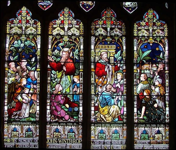
 St Bartholomew's Church, Groton | |
 Groton Location within Suffolk | |
| Area | 6.239 km2 (2.409 sq mi) |
| Population | 299 (2021 census) |
| • Density | 48/km2 (120/sq mi) |
| Civil parish |
|
| District | |
| Shire county | |
| Region | |
| Country | England |
| Sovereign state | United Kingdom |
| Post town | Sudbury |
| Postcode district | CO10 |
| UK Parliament | |

Groton is a village and civil parish in the Babergh district, Suffolk, England, located around a mile north of the A1071 between Hadleigh and Sudbury. In 2021 the parish had a population of 299. [1]
Contents
- History
- Broad Street
- Pitches Mount
- Castling's Heath
- Gosling Green
- Location grid
- Notable residents
- References
- External links
The parish church dedicated to Saint Bartholomew is flint faced and has some 15th-century features; it was heavily restored in the 19th century. It is a Commonwealth War Grave site. The village has no shops but does have the pub the Fox and Hounds. [2] In addition to Groton village, the parish contains the hamlets of Broad Street, Castling's Heath, Gosling Green, Horner's Green, and Parliament Heath. It is home to several Ancient Woodlands: the Groton Wood SSSI, the Mill Wood and Winding Wood nature reserves, and a section of Bull's Cross Wood (part of the Milden Thicks SSSI). Also found in the parish are a tributary to the River Box and Pitches Mount, the remaining earthworks of a wooden castle.
The parish borders Boxford, Edwardstone, Kersey, Lindsey and Milden. [3] There are 21 listed buildings in Groton. [4]