Avon was a non-metropolitan and ceremonial county in the west of England that existed between 1974 and 1996. The county was named after the River Avon, which flows through the area. It was formed from the county boroughs of Bristol and Bath, together with parts of the administrative counties of Gloucestershire and Somerset.

Bury St Edmunds, commonly referred to locally as Bury, is a historic market and cathedral town and civil parish in the West Suffolk district, in the county of Suffolk, England. The town is best known for Bury St Edmunds Abbey and St Edmundsbury Cathedral. Bury is the seat of the Diocese of St Edmundsbury and Ipswich of the Church of England, with the episcopal see at St Edmundsbury Cathedral. In 2011 it had a population of 45,000.

Until 1974, Denbighshire, or the County of Denbigh, was an administrative county in the north of Wales, later classed as one of the thirteen historic counties of Wales. It was a maritime county, that was bounded to the north by the Irish Sea, to the east by Flintshire, Cheshire and Shropshire, to the south by Montgomeryshire and Merionethshire, and to the west by Caernarfonshire.

The Metropolitan Borough of Westminster was a metropolitan borough in the County of London, England, from 1900 to 1965.
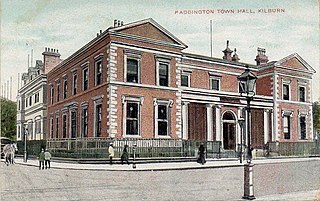
Paddington was a civil parish and metropolitan borough in London, England. It was an ancient parish in the county of Middlesex, governed by an administrative vestry. The parish was included in the area of responsibility of the Metropolitan Board of Works in 1855 and became part of the County of London in 1889. The parish of Paddington became a metropolitan borough in 1900, following the London Government Act 1899, with the parish vestry replaced by a borough council. In 1965 the borough was abolished and its former area became part of the City of Westminster in Greater London.

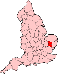
East Suffolk, along with West Suffolk, was created in 1888 as an administrative county of England. The administrative county was based on the eastern quarter sessions division of Suffolk. East Suffolk County Council's headquarters were at East Suffolk County Hall in Ipswich.
St Edmundsbury was a local government district and borough in Suffolk, England. It was named after its main town, Bury St Edmunds. The second town in the district was Haverhill. The population of the district was 111,008 at the 2011 Census.

The Metropolitan Borough of Solihull is a metropolitan borough in West Midlands county, England. It is named after its largest town, Solihull, from which Solihull Metropolitan Borough Council is based. For Eurostat purposes it is a NUTS 3 region and is one of seven boroughs or unitary districts that comprise the "West Midlands" NUTS 2 region. Much of the large residential population in the north of the borough centres on the communities of Castle Bromwich, Kingshurst, Marston Green and Smith's Wood as well as the towns of Chelmsley Wood and Fordbridge. In the south are the towns of Shirley and Solihull, as well as the large villages of Knowle, Dorridge, Meriden and Balsall Common.

Central Suffolk and North Ipswich is a constituency represented in the House of Commons of the UK Parliament since 2010 by Dan Poulter, a Conservative.

The Abbey of Bury St Edmunds was once among the richest Benedictine monasteries in England, until its dissolution in 1539. It is in the town that grew up around it, Bury St Edmunds in the county of Suffolk, England. It was a centre of pilgrimage as the burial place of the Anglo-Saxon martyr-king Saint Edmund, killed by the Great Heathen Army of Danes in 869. The ruins of the abbey church and most other buildings are merely rubble cores, but two very large medieval gatehouses survive, as well as two secondary medieval churches built within the abbey complex.

Bury St Edmunds is a constituency represented in the House of Commons of the UK Parliament since 2015 by Jo Churchill, a Conservative.

East Barnet Valley was a local government district from 1874 to 1965 around the town of East Barnet. It was partly in the counties of Hertfordshire and Middlesex until 1889, when the Middlesex part was transferred to Hertfordshire. It was renamed East Barnet in 1935.

Suffolk County Council is the administrative authority for the county of Suffolk, England. It is run by 75 elected county councillors representing 63 divisions. It is a member of the East of England Local Government Association.

Sutton and Cheam was a local government district in northeast Surrey, England from 1882 to 1965.
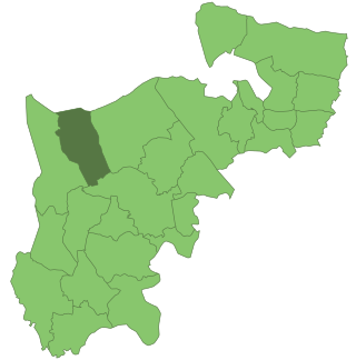
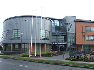
Ruislip-Northwood was an urban district in west Middlesex, England, from 1904 to 1965. From its inception Ruislip-Northwood fell within the Metropolitan Police District and from 1933 it was part of the London Passenger Transport Area.

Elstree Rural District was a rural district in Hertfordshire, England from 1894 to 1974.

Ixworth is a village and civil parish in the West Suffolk district of Suffolk, England, 6 miles (9.7 km) north-east of Bury St Edmunds on the A143 road to Diss and 9 miles (14 km) south-east of Thetford. The parish had a population of 2,365 at the 2011 Census.

Hardwick House was a manor house near Bury St Edmunds, Suffolk, owned by Sir Robert Drury, Speaker of the House of Commons, of Hawstead Place. It was subsequently purchased in the seventeenth century by Royalist Thomas Cullum, a former Sheriff of London. Experts in Suffolk county history as well as noted authorities in antiquarian and botanical matters, the Cullum family of eight successive baronets authored works on the county and its fauna and flora. Sir Thomas Gery Cullum, a Charterhouse graduate, medical doctor and member of the Royal Academy and the Linnean Society, was a well-regarded author on science and botany.
The Liberty of St Edmund covers the entire area of the former administrative County of West Suffolk. This area had been established by Edward the Confessor in 1044 and was a separate jurisdiction under the control of the Abbot of Bury St Edmunds Abbey until the dissolution of the monasteries affected Bury St Edmunds Abbey in 1539.
West Suffolk District is a local government district in Suffolk, England. It was established in 2019 as a merger of the previous Forest Heath District with the Borough of St Edmundsbury. The council is based in Bury St Edmunds, the district's largest town. The district also contains the towns of Brandon, Clare, Haverhill, Mildenhall and Newmarket, along with numerous villages and surrounding rural areas. In 2021 it had a population of 180,820.