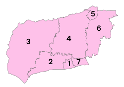
West Sussex | |
---|---|
![]() | |
Sovereign state | United Kingdom |
Constituent country | England |
Region | South East England |
Established | 1889 (administratively) , 1974 (ceremonially) |
Time zone | UTC±00:00 (Greenwich Mean Time) |
• Summer (DST) | UTC+01:00 (British Summer Time) |
Members of Parliament | 8 members |
Ceremonial county | |
Lord Lieutenant | Susan Pyper [1] |
High Sheriff | Timothy Fooks [2] (2020–21) |
Area | 1,991 km2 (769 sq mi) |
• Ranked | 30th of 48 |
Population (2021) | 858,852 |
• Ranked | 27th of 48 |
Density | 431/km2 (1,120/sq mi) |
Ethnicity | 96.6% White 1.7% S.Asian |
Non-metropolitan county | |
County council | ![]() West Sussex County Council |
Executive | Conservative |
Admin HQ | Chichester |
Area | 1,991 km2 (769 sq mi) |
• Ranked | 20th of 26 |
Population | 863,980 |
• Ranked | 9th of 26 |
Density | 434/km2 (1,120/sq mi) |
ISO 3166-2 | GB-WSX |
ONS code | 45 |
ITL | UKJ24 |
Website | www |
Districts | |
![]() Districts of West Sussex | |
Districts |
West Sussex is a county in South East England on the English Channel coast. The ceremonial county comprises the districts of Adur,Arun,Chichester,Horsham,and Mid Sussex,and the boroughs of Crawley and Worthing. Covering an area of 1,991 square kilometres (769 sq mi),West Sussex borders Hampshire to the west,Surrey to the north,and East Sussex to the east. The county town and only city in West Sussex is Chichester,located in the south-west of the county. In the 2011 census,West Sussex recorded a population of 806,900.
The county has a long history of human settlement dating back to the Lower Paleolithic era. The Romans conquered West Sussex's indigenous Britons,and incorporated the area as a Roman province. During the Early Middle Ages,the Saxons settled the area,establishing the Kingdom of Sussex in 477,which lasted until c. 827 when the kingdom was annexed by Wessex.
The West Sussex County Council was established in 1889 within the ceremonial County of Sussex. After the reorganisation of local government in 1974,the ceremonial function of the historic county of Sussex was divided into two separate counties,West Sussex and East Sussex. The existing East and West Sussex councils took control respectively,with Mid Sussex and parts of Crawley being transferred to the West Sussex administration from East Sussex.
West Sussex has a range of scenery,including wealden,downland and coastal. The highest point of the county is Blackdown,at 280 metres (919 ft). It has a number of stately homes including Goodwood,Petworth House and Uppark,and castles such as Arundel Castle and Bramber Castle. Over half the county is protected countryside,offering walking,cycling and other recreational opportunities. [3]
Although the name Sussex,derived from the Old English 'Sūþsēaxe' ('South Saxons'),dates from the Saxon period between AD 477 to 1066,the history of human habitation in Sussex goes back to the Old Stone Age. [4] The oldest hominin remains known in Britain were found at Eartham Pit,Boxgrove. [5] [6] Sussex has been occupied since those times and has succumbed to various invasions and migrations throughout its long history. [4] Prehistoric monuments include the Devil's Jumps,a group of Bronze Age burial mounds,and the Iron Age Cissbury Ring and Chanctonbury Ring hill forts on the South Downs.
The Roman period saw the building of Fishbourne Roman Palace and rural villas such as Bignor Roman Villa together with a network of roads including Stane Street,the Chichester to Silchester Way and the Sussex Greensand Way. The Romans used the Weald for iron production on an industrial scale. [7]
The foundation of the Kingdom of Sussex is recorded by the Anglo-Saxon Chronicle for the year AD 477;it says that Ælle arrived at a place called Cymenshore in three ships with his three sons and killed or put to flight the local inhabitants. The foundation story is regarded as somewhat of a myth by most historians,although the archaeology suggests that Saxons did start to settle in the area in the late 5th century. [8] [9] The Kingdom of Sussex was absorbed into Wessex as an earldom and became the county of Sussex.
With its origins in the kingdom of Sussex,the later county of Sussex was traditionally divided into six units known as rapes. By the 16th century,the three western rapes were grouped together informally,having their own separate Quarter Sessions. These were administered by a separate county council from 1888,the county of Sussex being divided for administrative purposes into the administrative counties of East and West Sussex. In 1974,West Sussex was made a single ceremonial county with the coming into force of the Local Government Act 1972. At the same time a large part of the eastern rape of Lewes (the Mid Sussex district which includes the towns of Haywards Heath,Burgess Hill and East Grinstead) was transferred into West Sussex.
Until 1834 provision for the poor and destitute in West Sussex was made at parish level. From 1835 until 1948 eleven Poor Law Unions,each catering for several parishes,took on the job. [10]
Most settlements in West Sussex are either along the south coast or in Mid Sussex,near the M23/A23 corridor. The town of Crawley is the largest in the county with an estimated population of 106,600. [11] The coastal settlement of Worthing closely follows with a population of 104,600. [11] The seaside resort of Bognor Regis and market town Horsham are both large towns. Chichester,the county town,has a cathedral and city status,and is situated not far from the border with Hampshire. Other conurbations of a similar size are Burgess Hill,East Grinstead and Haywards Heath in the Mid Sussex district,Littlehampton in the Arun district,and Lancing,Southwick and Shoreham in the Adur district. Much of the coastal town population is part of the Brighton/Worthing/Littlehampton conurbation.
Rustington and Southwater are the next largest settlements in the county. There are several more towns in West Sussex,although they are of similar size to other villages. The smaller towns of the county are Arundel,Midhurst,Petworth,Selsey and Steyning. The larger villages are Billingshurst,Copthorne,Crawley Down,Cuckfield,Henfield,Hassocks,Hurstpierpoint,Lindfield,Pulborough and Storrington. The current total population of the county makes up 1.53% of England's population.
West Sussex is bordered by Hampshire to the west,Surrey to the north and East Sussex to the east. The English Channel lies to the south. The area has been formed from Upper Jurassic and Lower Cretaceous rock strata,part of the Weald–Artois Anticline. The eastern part of this ridge,the Weald of Kent,Sussex and Surrey has been greatly eroded,with the chalk surface removed to expose older Lower Cretaceous rocks of the Wealden Group. [12] In West Sussex the exposed rock becomes older towards the north of the county with Lower Greensand ridges along the border with Surrey including the highest point of the county at Blackdown. Erosion of softer sand and clay strata has hollowed out the basin of the Weald leaving a north facing scarp slope of the chalk which runs east and west across the whole county,broken only by the valleys of the River Arun and River Adur. [13] In addition to these two rivers which drain most of the county a winterbourne,the River Lavant,flows intermittently from springs on the dip slope of the chalk downs north of Chichester. [14]
The county makes up 1.52% of the total land of England,making it the 30th largest county in the country. [15]
Bognor Regis | ||||||||||||||||||||||||||||||||||||||||||||||||||||||||||||
---|---|---|---|---|---|---|---|---|---|---|---|---|---|---|---|---|---|---|---|---|---|---|---|---|---|---|---|---|---|---|---|---|---|---|---|---|---|---|---|---|---|---|---|---|---|---|---|---|---|---|---|---|---|---|---|---|---|---|---|---|
Climate chart (explanation) | ||||||||||||||||||||||||||||||||||||||||||||||||||||||||||||
| ||||||||||||||||||||||||||||||||||||||||||||||||||||||||||||
|
West Sussex is the sunniest county in the United Kingdom,according to Met Office records. Over the 29 years to 2011 it averaged 1902 hours of sunshine per year. [17] Sunshine totals are highest near the coast with Bognor Regis often having the highest in mainland England,including a total of 2237 hours in 1990. Mean annual temperature for southern coastal counties is around 11 °C. The coldest month,January,has mean daily minimum temperatures of around 3 °C near the coast and lower inland. July tends to be the warmest month when mean daily maxima tend to be around 20 °C. A maximum temperature of 35.4 °C occurred at North Heath,Pulborough on 26 June 1976. Coastal high temperatures are often moderated by cooler sea breezes. [18]
Monthly rainfall tends to be highest in autumn and early winter and lowest in the summer months,with July often being the driest month. There is less rainfall from summer convective showers and thunderstorms than in inland areas. The county can suffer both from localised flooding caused by heavy rainfall and from water shortages caused by prolonged periods of below average rainfall. Winter rainfall is needed to recharge the chalk aquifers from which much of the water supply is drawn. [18]
West Sussex developed distinctive land uses along with its neighbours in the weald. The Landrace cattle transformed into Sussex cattle and Sussex chickens emerged about the time of the Roman conquest. [19] Some of the earliest evidence of horses in Britain has been found at Boxgrove,dated to 500,000 BC. Viticulture is a part of the economy,with wineries producing mainly sparkling wine of varied quality. [20]
The M23 Motorway runs from London to the south of Crawley. The A23 and A24 roads run from London to Brighton and Worthing respectively with the A29 a little further west ending in Bognor Regis. Other major roads are the A272 which runs east to west through the middle of the county and the A27 which does the same but closer to the coast. The A259 is a local alternate route to the A27 in the eastern coastal strip.
Gatwick Airport,which handled over 33 million passengers and had over 250,000 aircraft movements in 2011,is located within the borders of Crawley,and is the second largest airport in the United Kingdom. There is also a considerably smaller local airport at Shoreham and a grass airfield handling light aircraft and helicopters at Goodwood. There are three main railway routes:the Brighton Main Line,the Arun Valley Line and the West Coastway Line. The Portsmouth Direct Line serves and occasionally enters the westernmost part of West Sussex,although it has no railway stations in the county.
Since the 2015 general election,West Sussex has been represented entirely by Conservative Members of Parliament (MPs). [21]
Constituency | Constituency within West Sussex | Member of Parliament | Portrait | Party |
---|---|---|---|---|
Arundel &South Downs | ![]() | Andrew Griffith | ![]() | Conservative Party |
Bognor Regis &Littlehampton | ![]() | Nick Gibb | ![]() | Conservative Party |
Chichester | ![]() | Gillian Keegan | ![]() | Conservative Party |
Crawley | ![]() | Henry Smith | ![]() | Conservative Party |
Horsham | ![]() | Jeremy Quin | ![]() | Conservative Party |
Mid Sussex | ![]() | Mims Davies | ![]() | Conservative Party |
Worthing East &Shoreham | ![]() | Tim Loughton | ![]() | Conservative Party |
Worthing West | ![]() | Peter Bottomley | ![]() | Conservative Party |
West Sussex County Council (WSCC) is the authority that governs the non-metropolitan county of West Sussex. The county contains 7 district and borough councils (Adur,Arun,Chichester,Crawley,Horsham,Mid Sussex and Worthing),and 159 town,parish and neighbourhood councils.
West Sussex County Council has 71 councillors;the majority of them being Conservative. There are 46 Conservative councillors,10 UK Independence Party,8 Liberal Democrats,6 Labour Party councillors and 1 Independent councillor. [22] The Chief Executive and his team of Executive Directors are responsible for the day-to-day running of the council.
West Sussex County Council is based at County Hall,Chichester and provides a large range of services including education,social services,fire and rescue,libraries,trading standards,town and country planning,refuse disposal and consumer services.
The West Sussex Youth Cabinet is a group of local representatives and four UK Youth Parliament (UKYP) representatives,who are elected by young people in West Sussex. [23] The Youth Cabinet represents the views of the young people West Sussex at county level. Elections for the Youth Cabinet and UKYP in West Sussex run every year in March.[ citation needed ]
The Cathedral Church of the Holy Trinity,otherwise called Chichester Cathedral,is the seat of the Anglican Bishop of Chichester. It was founded as a cathedral in 1075,when the seat of the bishop was moved from Selsey Abbey. [25] The cathedral has architecture in both the Norman and the Gothic styles,and has been called by the architectural historian Nikolaus Pevsner "the most typical English Cathedral". [26] The Cathedral Church of Our Lady and St Philip Howard in Arundel is the Roman Catholic cathedral of the Diocese of Arundel and Brighton. Built in French Gothic style and dedicated in 1873 as the Catholic parish church of Arundel,it was not designated a cathedral until the foundation of the diocese in 1965. [27]
Bosham Church is partly of Saxon construction and is shown on the Bayeux Tapestry as the local church of late Saxon and Danish kings of England. [28] Many other Saxon and early Norman have survived in the county with little alteration including the Church of St Mary the Blessed Virgin,Sompting,an 11th-century Anglo-Saxon church with a Rhenish helm unique in England and St. Nicholas Church,Worth,a 10th-century church in Worth,Crawley. Some Anglican churches and many of the numerous nonconformist chapels in the county have been converted to residential use. Cittaviveka is a Buddhist monastery in Chithurst.
Pallant House Gallery in Chichester houses one of the most significant collections of 20th-century British art outside London. It includes a substantial body of early and mid-20th-century work bequeathed by Walter Hussey and many later works donated by Sir Colin St John 'Sandy' Wilson.
Worthing Museum and Art Gallery houses a large collection of Georgian and Victorian costume. The Cass Sculpture Foundation has an outdoor sculpture park at Goodwood.
BBC South covers the county excluding Haywards Heath,Burgess Hill,East Grinstead and Shoreham-by-Sea which are covered by BBC South East. [32] ITV Meridian also covers the county. Crawley is covered by both regions and by BBC London and ITV London. [33]
This is a table of trend of regional gross value added of West Sussex at current basic prices published by Office for National Statistics with figures in millions of British Pounds Sterling. [34]
Year | Regional gross value added [35] | Agriculture [36] | Industry [37] | Services [38] |
---|---|---|---|---|
1995 | 8,564 | 208 | 2,239 | 6,116 |
2000 | 10,576 | 162 | 2,545 | 7,869 |
2003 | 12,619 | 185 | 2,520 | 9,915 |
Significant companies in the county include Rolls-Royce Motor Cars,a substantial employer near Chichester. Gatwick Airport,with associated airlines including British Airways and Virgin Atlantic,is a major source of direct and indirect employment. Thales Group also has a presence in the county. Nestlé has their UK headquarters in Crawley.
The table below shows the population change up to the 2011 census,contrasting the previous census. It also shows the proportion of residents in each district reliant upon lowest income and/or joblessness benefits,the national average proportion of which was 4.5% as at August 2012,the year for which latest datasets have been published. It can be seen that the most populous district of West Sussex is Arun containing the towns of Arundel,Bognor Regis and Littlehampton:
Unit | JSA or Inc. Supp. claimants (August 2012) % of 2011 population | JSA and Income Support claimants (August 2001) % of 2001 population | Population (April 2011) | Population (April 2001) |
---|---|---|---|---|
West Sussex | 2.7% | 5.1% | 806,892 | 753,614 |
Ranked by district | ||||
Crawley | 3.8% | 5.3% | 106,597 | 99,744 |
Worthing | 3.6% | 6.7% | 104,640 | 97,568 |
Adur | 3.2% | 6.3% | 61,182 | 59,627 |
Arun | 3.0% | 6.4% | 149,518 | 140,759 |
Chichester | 2.3% | 4.8% | 113,794 | 106,450 |
Horsham | 1.9% | 3.3% | 131,301 | 122,088 |
Mid Sussex | 1.6% | 3.6% | 139,860 | 127,378 |
West Sussex has a comprehensive education system,with a mix of county-maintained secondary schools and academies and over twenty independent senior schools. In addition primary education is provided through a mix of around 240 infant,junior,primary,first and middle schools.
Colleges include The College of Richard Collyer,Central Sussex College,Northbrook College and The Weald School.
Independent schools in the county include Christ's Hospital near Horsham,whose students wear Tudor style uniform,Seaford College,Lancing College and Hurstpierpoint College.
Tertiary education is provided by the University of Chichester and Chichester College.
At least 40 sports are active in West Sussex. Sussex was the first First-Class cricket county formed in 1839 and was a cradle for club cricket. [40] [41] Sussex is home to Fontwell Park Racecourse. [42] The county has one Football League club located in Crawley,that is Crawley Town F.C. [43]
Sussex, from the Old English Sūþsēaxe, is a historic county in South East England that was formerly an independent medieval Anglo-Saxon kingdom. It is bounded to the west by Hampshire, north by Surrey, northeast by Kent, south by the English Channel, and divided for many purposes into the ceremonial counties of West Sussex and East Sussex.
Arun is a local government district in West Sussex, England. It contains the towns of Arundel, Bognor Regis and Littlehampton, and takes its name from the River Arun, which runs through the centre of the district.
The Roman Catholic Diocese of Arundel and Brighton is a Latin Church Roman Catholic diocese in southern England covering the counties of Sussex and Surrey. The diocese was erected on 28 May 1965 by Pope Paul VI, having previously been a part of the larger Diocese of Southwark, which was elevated to an archdiocese with a new ecclesiastical province on the same date.
Arundel railway station serves the market town of Arundel in West Sussex. The station is on the eastern side of the town, about 550 yards (500 m) from the High Street, across the River Arun. It is 58 miles 28 chains (93.9 km) down the line from London Bridge via Redhill.
Sussex is a historic county and cultural region in the south of England corresponding roughly in area to the ancient Kingdom of Sussex. It is bounded on the north by Surrey, north-east by Kent, south by the English Channel, and west by Hampshire, and is divided for local government into West Sussex and East Sussex and the city of Brighton and Hove. The city of Brighton & Hove was created a unitary authority in 1997, and was granted City status in 2000. Until then Chichester had been Sussex's only city. By convention, Chichester is Sussex's capital city and Lewes is Sussex's county town.
The Rape of Bramber is one of the rapes, the traditional sub-divisions unique to the historic county of Sussex in England. It is the smallest Sussex rape by area. Bramber is a former barony whose original seat was the castle of Bramber and its village, overlooking the river Adur.
The geology of West Sussex in southeast England comprises a succession of sedimentary rocks of Cretaceous age overlain in the south by sediments of Palaeogene age. The sequence of strata from both periods consists of a variety of sandstones, mudstones, siltstones and limestones. These sediments were deposited within the Hampshire and Weald basins. Erosion subsequent to large scale but gentle folding associated with the Alpine Orogeny has resulted in the present outcrop pattern across the county, dominated by the north facing chalk scarp of the South Downs. The bedrock is overlain by a suite of Quaternary deposits of varied origin. Parts of both the bedrock and these superficial deposits have been worked for a variety of minerals for use in construction, industry and agriculture.
Healthcare in Sussex was the responsibility of seven Clinical Commissioning Groups covering: Brighton and Hove; Coastal West Sussex; Horsham and Mid Sussex; Crawley; Eastbourne Hailsham and Seaford; Hastings and Rother; High Weald; and Lewes-Havens from 2013 to 2020. From April 2020 they were merged into three covering East Sussex, West Sussex, and Brighton and Hove.
Religion in Sussex has been dominated over the last 1,400 years by Christianity. Like the rest of England, the established church in Sussex is the Church of England, although other Christian traditions exist. After Christianity, the religion with the most adherents is Islam, followed by Hinduism, Buddhism, Judaism and Sikhism.
The history of Christianity in Sussex includes all aspects of the Christianity in the region that is now Sussex from its introduction to the present day. Christianity is the most commonly practised religion in Sussex.
The history of local government in Sussex is unique and complex. Founded as a kingdom in the 5th century, Sussex was annexed by the kingdom of Wessex in the 9th century, which after further developments became the Kingdom of England. It currently corresponds to two counties, East Sussex and West Sussex.
{{cite journal}}
: Cite journal requires |journal=
(help){{cite web}}
: |first=
has generic name (help)