South Coast Plain

Last updated
South Coast Plain
Region
River Hamble - geograph.org.uk - 1435001.jpg
River Hamble
Coordinates: 50°50′N0°40′W / 50.833°N 0.667°W / 50.833; -0.667 Coordinates: 50°50′N0°40′W / 50.833°N 0.667°W / 50.833; -0.667
Country England
Region Hampshire, Sussex
Area
  Total 522.45 km2 (201.72 sq mi)
Population (2001)
  Total 505,822 [1]

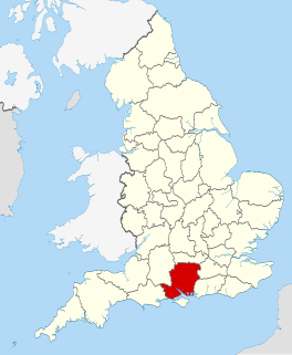
The South Coast Plain is a natural region in England running along the central south coast in the counties of East and West Sussex and Hampshire.

East Sussex County of England

East Sussex is a county in South East England. It is bordered by the counties of Kent to the north and east, Surrey to the north west and West Sussex to the west, and to the south by the English Channel.

West Sussex County of England

West Sussex is a county in the south of England, bordering East Sussex to the east, Hampshire to the west and Surrey to the north, and to the south the English Channel.

Hampshire County of England

Hampshire is a county on the southern coast of England. The county town, with city status, is Winchester, a frequent seat of the Royal Court before any fixed capital, in late Anglo-Saxon England. After the metropolitan counties and Greater London, Hampshire is the most populous ceremonial county in the United Kingdom. Its two largest settlements, Southampton and Portsmouth, are administered separately as unitary authorities and the rest of the area forms the administrative county, which is governed by Hampshire County Council.

It has been designated as National Character Area No. 126 by Natural England. The NCA has a total area of 52,245 hectares and forms a coastal strip, 2 to 16 kilometres wide, running from the area of Hamble-le-Rice in Hampshire in the west across the entire length of West Sussex to Brighton in East Sussex to the east. [1]

A National Character Area (NCA) is a natural subdivision of England based on a combination of landscape, biodiversity, geodiversity and economic activity. There are 159 National Character Areas and they follow natural, rather than administrative, boundaries. They are defined by Natural England, the UK government's advisors on the natural environment.

Natural England is a non-departmental public body in the United Kingdom sponsored by the Department for Environment, Food and Rural Affairs. It is responsible for ensuring that England's natural environment, including its land, flora and fauna, freshwater and marine environments, geology and soils, are protected and improved. It also has a responsibility to help people enjoy, understand and access the natural environment.

Hamble-le-Rice village in the United Kingdom

Hamble-le-Rice is a village and civil parish in the Borough of Eastleigh in Hampshire, UK. It is best known for being an aircraft training centre during the Second World War and is a popular yachting location. The village and the River Hamble also featured in the 1980s BBC television series Howards' Way. The village centre, known as The Square, Hamble, has a more traditional English village aesthetic which differentiates it from the small industrial areas close-by the village.

Its major settlements include the cities of Brighton and Hove, Chichester and Portsmouth, the market town of Fareham, the coastal town of Gosport and the seaside resorts of Bognor Regis, Littlehampton and Worthing. It is bordered by the New Forest across Southampton Water to the west, the South Hampshire Lowlands to the northwest, the South Downs to the north and east, and the Isle of Wight across the Solent to the southwest. [1]

Brighton and Hove City and unitary authority in England

Brighton and Hove is a seaside city in East Sussex, in South East England. The towns of Brighton and Hove formed a unitary authority in 1997 and in 2001 were granted city status by Queen Elizabeth II. "Brighton" is often referred to synonymously with the official "Brighton and Hove" although many locals still consider the two to be separate towns. At the 2011 census, the city was England's most populous seaside resort, with a population of 273,400.

Chichester Cathedral city in West Sussex, England

Chichester is a cathedral city in West Sussex, in South-East England. It is the only city in West Sussex and is its county town. It has a long history as a settlement from Roman times and was important in Anglo-Saxon times. It is the seat of the Church of England Diocese of Chichester, with a 12th-century cathedral.

Portsmouth City & unitary authority area in England

Portsmouth is a port city in Hampshire, England, with a total population of 205,400 residents. The city of Portsmouth is nicknamed Pompey and is mainly built on Portsea Island, a flat, low-lying island measuring 24 square kilometres in area, just off the south-east coast of Hampshire. Uniquely, Portsmouth is the only island city in the United Kingdom, and is the only city whose population density exceeds that of London.

See also

Related Research Articles

Hastings Town and Borough in United Kingdom

Hastings is a town and borough in East Sussex on the south coast of England, 24 mi (39 km) east of the county town of Lewes and 53 mi (85 km) south east of London. It has an estimated population of 90,254.

Sussex historic county in South East England

Sussex, from the Old English Sūþsēaxe, is a historic county in South East England corresponding roughly in area to the ancient Kingdom of Sussex. It is bounded to the west by Hampshire, north by Surrey, northeast by Kent, south by the English Channel, and divided for many purposes into the ceremonial counties of West Sussex and East Sussex. Brighton and Hove, though part of East Sussex, was made a unitary authority in 1997, and as such, is administered independently of the rest of East Sussex. Brighton and Hove was granted City status in 2000. Until then, Chichester was Sussex's only city.

Hove Town on the south coast of England, part of city of Brighton & Hove

Hove is a town in East Sussex, England, immediately west of its larger neighbour Brighton, with which it forms the unitary authority Brighton and Hove. It forms a single conurbation with Brighton and some smaller towns and villages running along the coast. As part of local government reform, Brighton and Hove were merged, to form the borough of Brighton and Hove in 1997. In 2001, the new borough officially attained city status.

Weald an area of South East England

The Weald is an area of South East England between the parallel chalk escarpments of the North and the South Downs. It crosses the counties of Sussex, Hampshire, Kent and Surrey and has three separate parts: the sandstone "High Weald" in the centre; the clay "Low Weald" periphery; and the Greensand Ridge, which stretches around the north and west of the Weald and includes its highest points. The Weald once was covered with forest, and its name, Old English in origin, signifies "woodland". The term is still used today, as scattered farms and villages sometimes refer to the Weald in their names.

South Downs Way

The South Downs Way is a long distance footpath and bridleway running along the South Downs in southern England. It is one of 15 National Trails in England and Wales. The trail runs for 160 km (100 mi) from Winchester in Hampshire to Eastbourne in East Sussex, with about 4,150 m (13,620 ft) of ascent and descent.

South Downs mountain range

The South Downs are a range of chalk hills that extends for about 260 square miles (670 km2) across the south-eastern coastal counties of England from the Itchen Valley of Hampshire in the west to Beachy Head, near Eastbourne, East Sussex, in the east. The Downs are bounded on the northern side by a steep escarpment, from whose crest there are extensive views northwards across the Weald. The South Downs National Park forms a much larger area than the chalk range of the South Downs and includes large parts of the Weald.

A27 road major road in southern England

The A27 is a major road in England. It runs from its junction with the A36 at Whiteparish in the county of Wiltshire. It closely parallels the south coast in Hampshire, then passes through West Sussex and terminates at Pevensey in East Sussex.

Chichester District Non-metropolitan district in England

Chichester is a largely rural local government district in West Sussex, England. Its council is based in the city of Chichester.

A259 road road in England

The A259 is a road on the south coast of England passing through Hampshire, West Sussex, East Sussex and part of Kent. The main part of the road connects Brighton, Eastbourne, Hastings, Rye and Folkestone.

South Downs National Park

The South Downs National Park is England's newest national park, having become fully operational on 1 April 2011. The park, covering an area of 1,627 square kilometres (628 sq mi) in southern England, stretches for 140 kilometres (87 mi) from Winchester in the west to Eastbourne in the east through the counties of Hampshire, West Sussex and East Sussex. The national park covers the chalk hills of the South Downs and a substantial part of a separate physiographic region, the western Weald, with its heavily wooded sandstone and clay hills and vales. The South Downs Way spans the entire length of the park and is the only National Trail that lies wholly within a national park.

Southern England Chalk Formation

The Chalk Formation of Southern England is a system of chalk downland in the south of England. The formation is perhaps best known for Salisbury Plain, the location of Stonehenge, the Isle of Wight, and the twin ridgeways of the North Downs and South Downs.

West Coastway line railway line in England

The West Coastway line is a railway line in England following closely the south coast of Sussex and Hampshire, between the cities of Brighton and Southampton. It has short southward branches to Littlehampton and Bognor Regis. Some trains using part of the route operate as direct continuations of passenger services to/from London, particularly those to the branch stations mentioned.

Geography of Sussex

Sussex is a historic county and cultural region in the south of England corresponding roughly in area to the ancient Kingdom of Sussex. It is bounded on the north by Surrey, north-east by Kent, south by the English Channel, and west by Hampshire, and is divided for local government into West Sussex and East Sussex and the city of Brighton and Hove. The city of Brighton & Hove was created a unitary authority in 1997, and was granted City status in 2000. Until then Chichester had been Sussex's only city. By convention, Chichester is Sussex's capital city and Lewes is Sussex's county town.

Coastliner 700

Coastliner 700 is a bus service operated in West Sussex and south east Hampshire, England, by Stagecoach South between Brighton and Southsea via Worthing, Littlehampton, Wick, Bognor Regis, Chichester, Havant, and Portsmouth with a general daytime frequency of every ten minutes. The route has its own livery and is usually operated with double-decker buses.

South Hampshire Lowlands

The South Hampshire Lowlands form a natural landscape in south, central England within the county of Hampshire.

North Northumberland Coastal Plain

The North Northumberland Coastal Plain is a major natural region that lies on England's northeasternmost stretch of coastline on the North Sea. To the west lie the Cheviot Fringe, the Northumberland Sandstone Hills and Mid Northumberland; to the south it is continued by the South East Northumberland Coastal Plain.

Brighton and Lewes Downs Biosphere Reserve Biosphere reserve in United Kingdom | designated in 2014

The Brighton and Lewes Downs Biosphere Reserve is a UNESCO Biosphere Reserve located in Sussex on the southeast coast of England near the city of Brighton and Hove. Forming a central unit of the hills of the South Downs National Park, it is centred on the Brighton chalk block that lies between the River Adur in the west and the River Ouse in the east. Chalk downland makes up the principal terrestrial landscape of the area, bounded at each end by the two river valleys. The coastline is dominated by impressive chalk cliffs in the east and urbanized plains in the west, running to the estuary of the River Adur at Shoreham-by-Sea. The area is nationally and internationally renowned for its arts and culture, distinctive settlements, independent mindset and its links to the surrounding iconic English landscape of downland, white chalk cliffs and beaches.

References

  1. 1 2 3 NCA 126: South Coast Plain - Key Facts & Data at www.naturalengland.org.uk. Accessed on 5 Apr 2013.