River Test | |
---|---|
![]() The Test downstream of Sadler's Mill, Romsey | |
![]() River Test highlighted in red, shown in South East England | |
Location | |
Country | England |
Counties | Hampshire |
Physical characteristics | |
Source | |
• location | Ashe, near Overton, Hampshire, United Kingdom |
• coordinates | 51°14′43″N1°14′21″W / 51.2454°N 1.2392°W |
• elevation | 90 m (300 ft) |
Mouth | Southampton Water |
• location | Southampton, Hampshire |
• coordinates | 50°55′30″N1°28′45″W / 50.9251°N 1.4792°W |
• elevation | 0 m (0 ft) |
Length | 64 km (40 mi) |
Width | |
• minimum | 1 m (3 ft 3 in) |
• average | 20 m (66 ft) |
• maximum | 56 m (184 ft) |
Depth | |
• minimum | 0.5 m (1 ft 8 in) |
• average | 2 m (6 ft 7 in) |
• maximum | 4 m (13 ft) |
Basin features | |
Tributaries | |
• left | River Blackwater, River Dun, Wallop Brook, River Anton, Pilhill Brook |
• right | River Dever, Bourne Rivulet, River Swift |
Site of Special Scientific Interest | |
![]() River Test at Tufton | |
Grid reference | SU 384 355 [1] |
Interest | Biological |
Area | 438.0 hectares (1,082 acres) [1] |
Notification | 1996 [1] |
Location map | Magic Map |
The River Test is a chalk stream in Hampshire in the south of England. It rises at Ashe near Basingstoke and flows southwards for 40 miles (64 km) to Southampton Water. Settlements on the Test include the towns of Stockbridge and Romsey. The river's valley gives its name to the local government district of Test Valley. Below the village of Longparish, the river is broadly followed by the Test Way, a long-distance footpath. [2]
Much of the Test is a 438-hectare (1,080-acre) biological Site of Special Scientific Interest. [1] [3] It is part of the Solent and Southampton Water Ramsar site [4] and Special Protection Area. [5] The river is used for fly fishing for trout from its source to its tidal limit. [6]
Recorded forms are Terstan from 877 and 901, Tarstan stream in 1045, Terstein 1234, and Test in 1425. If Common Brittonic, not Old English, all related dictionaries show three suitable words beginning with Tre- and none with extremely rare Ter-. There is precedent to such metathesis: as for the river Tern in the far west, from tren 'strong'. [7] If so it most likely relates to the Welsh tres (tumult, commotion, contention, uproar) or trais (force, might in older Welsh). [7] A close set of words (diversely conjugated and pronounced) in Old English is (f)irst(en), the meaning of which is as at present, first.
The river rises near the village of Ashe, 7 miles (11 km) to the west of Basingstoke (at grid reference SU 532,498 ), and flows west through the villages of Overton, Laverstoke, and the town of Whitchurch, before joining with the Bourne Rivulet at Testbourne and turning in a more southerly direction. It then proceeds through the villages of Longparish and Middleton to Wherwell and Chilbolton, where the Rivers Dever and Anton join. [8]
From Chilbolton the river goes through the villages of Leckford, Longstock, Stockbridge and Houghton to Mottisfont and Kimbridge, where the River Dun joins the flow. From here the village of Timsbury is passed, then through the grounds of Roke Manor before reaching the town of Romsey. On the western edge of Romsey, Sadler's Mill, an 18th-century watermill, sits astride the River Test. [9]
South of Romsey, the river passes the country house of Broadlands, and then Nursling, once the site of a Roman bridge. Finally the river is joined by the River Blackwater and soon becomes tidal, widening out into a considerable estuary that is lined on its northern bank by the container terminals and quays of the Port of Southampton. The Test estuary then meets that of the River Itchen and the two continue to the sea as Southampton Water. [10]
Between Chilbolton and Redbridge, the river was once paralleled by the Andover Canal, which was itself converted to a railway in 1865, and then in turn abandoned. Most traces of the canal have disappeared, although the remains of a stretch can still be seen between Timsbury and Romsey. [11]
This chalk stream has one of the richest fauna and flora of any lowland river in England. More than 100 species of flowering plant have been recorded along its banks and 232 invertebrate taxa in the river. It is also important for wetland birds, with breeding species including kingfishers, grey wagtails and little grebes. [12]
The Environment Agency measure water quality of the river systems in England. Each is given an overall ecological status, which may be one of five levels: high, good, moderate, poor and bad. There are several components that are used to determine this, including biological status, which looks at the quantity and varieties of invertebrates, angiosperms and fish. Chemical status, which compares the concentrations of various chemicals against known safe concentrations, is rated good or fail. [13]
Water quality of the River Test in 2019:
Section | Ecological Status | Chemical Status | Overall Status | Length | Catchment | Channel |
---|---|---|---|---|---|---|
Test (Upper) [14] | Good | Fail | Moderate | 14.803 km (9.198 mi) | 177.062 km2 (68.364 sq mi) | |
Test - Bourne Rivulet to conf Dever [15] | Good | Fail | Moderate | 8.286 km (5.149 mi) | 32.01 km2 (12.36 sq mi) | |
Test - conf Dever to conf Anton [16] | Good | Fail | Moderate | 3.869 km (2.404 mi) | 13.295 km2 (5.133 sq mi) | |
Test - conf Anton to conf Dun [17] | Good | Fail | Moderate | 28.075 km (17.445 mi) | 56.88 km2 (21.96 sq mi) | |
Test - conf Dun to Tadburn Lake [18] | Moderate | Fail | Moderate | 8.439 km (5.244 mi) | 19.045 km2 (7.353 sq mi) | heavily modified |
Test (Lower) [19] | Good | Fail | Moderate | 8.579 km (5.331 mi) | 3.91 km2 (1.51 sq mi) |
The river features in Richard Adams' 1972 novel Watership Down . [20] When the Watership rabbits are pursued by an enemy force, one rabbit carries out a plan which leads to their successful escape down the Test on a punt. In the text, readers are told that this plan would not have been possible on most rivers, but the Test's smooth-flowing, weed-free nature makes it an exception. The punt becomes lodged on a low bridge, and the surviving rabbits are forced to swim under the bridge to the riverbank. [20]
The following are the named tributaries of the River Test, listed in order upstream from Southampton Water. [21]
The River Hamble is located in south Hampshire, England. It rises near Bishop's Waltham and flows for 10.1 km (6.3 mi) through Botley, Bursledon, and Lower Swanwick before entering Southampton Water between Hamble Common and Warsash.
The River Lugg rises near Llangynllo in Radnorshire, Wales. It flows through the border town of Presteigne and then through Herefordshire, England, where it meets its main tributary, the River Arrow, to the south of Leominster. It flows into the River Wye downstream of Hereford at Mordiford, around 63 miles (101 km) from its source. Its name comes from a Welsh root, and means "bright stream".
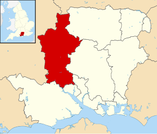
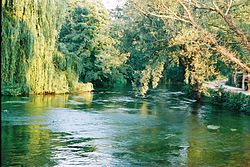
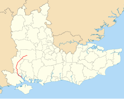
Test Valley is a local government district with borough status in Hampshire, England, named after the valley of the River Test. The council is based in the borough's largest town of Andover. The borough also contains the town of Romsey and numerous villages and surrounding rural areas. A small part of the borough at its southern end lies within the New Forest National Park, and part of the borough north of Andover lies within the North Wessex Downs, a designated Area of Outstanding Natural Beauty.
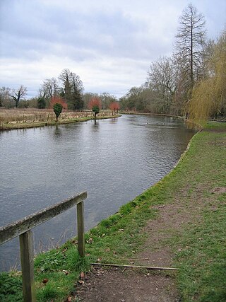
The River Itchen in Hampshire, England, rises to the south of New Alresford and flows 26 miles (42 km) to meet Southampton Water below the Itchen Bridge. The Itchen Navigation was constructed in the late 17th and early 18th centuries to enable barges to reach Winchester from Southampton Docks, but ceased to operate in the mid-19th century and is largely abandoned today.
The Andover Canal was a canal built in Hampshire, England. It ran 22 miles (35 km) from Andover to Redbridge through Stockbridge and Romsey. The canal had a fall of 179 feet (55 m) through 24 locks, and for much of its length paralleled the River Anton and River Test. It opened in 1794, but was never a commercial success. The only dividend paid to shareholders was in 1859, using the proceeds from the sale of the canal to the London and South Western Railway, who bought it to lay a railway line along much of its course. The railway line is now also defunct.
The River Clun runs mostly through Shropshire, England and joins the River Teme at Leintwardine, Herefordshire. The Clun Valley is part of the Shropshire Hills AONB.
The River Meon is a chalk stream in Hampshire in the south of England. It rises at East Meon then flows 34 km (21 mi) in a generally southerly direction to empty into the Solent at Hill Head near Stubbington. Above Wickham, the river runs through the South Downs National Park.
The Beaulieu River, formerly known as the River Exe, is a small river draining much of the central New Forest in Hampshire, southern England. The river has many small upper branches and its farthest source is 8 miles (13 km) from its 4 miles (6 km)-long tidal estuary. Unusually, the river, including its bed, is owned by Lord Montagu of Beaulieu.
The River Itchen flows through east Warwickshire in England. It is a small river, about 18 miles (29 km) long, and its general course is from south to north.
Bransbury is a hamlet in Hampshire, England, part of the parish of Barton Stacey. The nearest village is Barton Stacey, halfway between Winchester and Andover; there is a junction for Bransbury on the A303 towards Exeter. Bransbury has twenty-two dwellings: a collection of agricultural workers’ cottages with gardens of generous proportions, Bransbury Manor, which dates from the 18th century, and Bransbury Mill, a Grade II listed building. The Crook and Shears Inn public house was converted into a dwelling in the late 20th century. The hamlet straddles the River Dever.
The Test Way is a 44-mile (71 km) long-distance footpath in England from Walbury Hill in West Berkshire to Eling in Hampshire, which follows much of the course of the River Test.
The River Vyrnwy flows through northern Powys, Wales, and Shropshire, England. The name derives from Severn, the river of which it is a tributary.
This River Blackwater drains small parts of the English counties of Hampshire and Wiltshire. It is a tributary of the River Test.
The River Anton is a chalk stream in Hampshire in south east England. It rises in Andover and flows southwards for approximately 8 miles (13 km) to meet the River Test near Chilbolton. The principal tributary of the Anton, the Pillhill Brook, joins the river at Upper Clatford.
The River Dever is a chalk stream in Hampshire in the south of England. It rises at West Stratton near Micheldever and flows westwards for 11 mi (18 km) to meet the River Test at Wherwell.
The River Brun is a river in eastern Lancashire. It is approximately 4.5 miles (7.2 km) long and has a catchment area of 9.32 square miles (24.134 km2).
The Sprat and Winkle Line was the common name of the Andover to Redbridge railway line which ran between Andover and Redbridge in Hampshire, England. In the Romsey area it joined, and then left, the Salisbury to Southampton line. It was built by the Andover and Redbridge Railway, which was incorporated in 1858. In 1863 the uncompleted railway was taken over by the London and South Western Railway (LSWR), which opened the line in 1865. The line had been conceived as part of a trunk route from Manchester to Southampton, but when the Midland and South Western Junction Railway opened, the anticipated long-distance traffic was disappointing.
The River Dun is a tributary of the River Test in southern England, which flows for 18.3 km in a generally easterly direction through rural parts of Wiltshire and Hampshire.