
The Sussex Wildlife Trust (SWT) is a conservation charity which aims to protect natural life in Sussex. It was founded in 1961 and is one of 46 wildlife trusts across the UK and the Isle of Man and Alderney. As of 2019, it has 33,000 members and manages 2,000 hectares of land for nature. It is a registered charity and in the year to 31 March 2019 it had an income of £5.7 million and expenditure of £4 million, resulting in net income of £1.7 million.

Pewsey Downs is a 305.3 hectare biological Site of Special Scientific Interest on the southern edge of the Marlborough Downs north of Pewsey in Wiltshire, notified in 1951. It includes the Pewsey Downs National Nature Reserve.

River Avon System is a 475.9-hectare (1,176-acre) biological Site of Special Scientific Interest in Hampshire and Wiltshire, southern England. It is a Nature Conservation Review site, Grade I. It is part of the Avon Valley and New Forest Ramsar sites and is also part of two Special Protection Areas: Solent and Southampton Water, and the New Forest.

Colyers Hanger is a 26.6-hectare (66-acre) biological Site of Special Scientific Interest south-east of Guildford in Surrey. It is a Nature Conservation Review site, Grade 2 and is part of St Martha's Hill and Colyer's Hanger nature reserve, which is managed by the Surrey Wildlife Trust.

Farlington Marshes is a 119.7-hectare (296-acre) Local Nature Reserve in Portsmouth in Hampshire. It is owned by Portsmouth City Council and managed by Hampshire and Isle of Wight Wildlife Trust. It is part of Langstone Harbour, which is a Site of Special Scientific Interest and a Nature Conservation Review site, Grade I. It is also part of Solent Maritime Special Area of Conservation and of Chichester and Langstone Harbours Ramsar site and Special Protection Area.
Sandwich Bay to Hacklinge Marshes is a 1,790.1-hectare (4,423-acre) biological and geological Site of Special Scientific Interest which stretches between Deal and Sandwich in Kent. It includes two Geological Conservation Review sites, and most of it is a Nature Conservation Review site, Grade I. Part of it is a Ramsar site, a Special Area of Conservation, a Special Protection Area and a National Nature Reserve, It also includes a Kent Wildlife Trust nature reserve and a Local Nature Reserve,

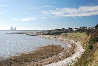
South Thames Estuary and Marshes is a 5,289-hectare (13,070-acre) biological Site of Special Scientific Interest which stretches between Gravesend and the mouth of the River Medway in Kent. Part of it is a Nature Conservation Review site, Grade I, and part is a Royal Society for the Protection of Birds nature reserve. It is part of the Thames Estuary and Marshes Ramsar internationally important wetland site and Special Protection Area under the European Union Directive on the Conservation of Wild Birds.

Ant Broads and Marshes is a 745.3-hectare (1,842-acre) biological Site of Special Scientific Interest north-east of Norwich in Norfolk. Most of it is a Nature Conservation Review site, Grade 1, and it is part of the Broadland Ramsar and Special Protection Area, and The Broads Special Area of Conservation. Part of it is the Barton Broad nature reserve, which is managed by the Norfolk Wildlife Trust, and two areas are National Nature Reserves.

Barnham Cross Common is a 69.1-hectare (171-acre) biological Site of Special Scientific Interest on the southern outskirts of Thetford in Norfolk. It is owned by Thetford Town Council and is registered common land. It is also a Local Nature Reserve and a Nature Conservation Review site, Grade 1. It is part of the Breckland Special Area of Conservation and Special Protection Area.

Yare Broads and Marshes is a 744.5-hectare (1,840-acre) biological Site of Special Scientific Interest east of Norwich in Norfolk, England. Part of the site, is a Nature Conservation Review site, Grade I and most of it is in the Mid-Yare National Nature Reserve. It is part of the Broadland Ramsar site and Special Protection Area, and The Broads Special Area of Conservation. Two ares are Royal Society for the Protection of Birds nature reserves, Strumpshaw Fen and Surlingham Church Marsh.
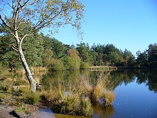
Thursley, Hankley and Frensham Commons is a 1,878.5-hectare (4,642-acre) biological Site of Special Scientific Interest west of Godalming in Surrey. Thursley and Hankley Commons are Nature Conservation Review sites, Grade I. An area of 115.1 hectares is a local nature reserve called The Flashes and an area of 180 hectares is the Elstead Group of Commons, a nature reserve managed by the Surrey Wildlife Trust. Thursley Common is a national nature reserve. An area of 265.7 hectares is the Thursley & Ockley Bogs Ramsar site. The site is a Special Protection Area and part of the Thursley, Ash, Pirbright & Chobham Special Area of Conservation.

Parsonage Moor is a 6-hectare (15-acre) nature reserve north-west of Abingdon-on-Thames in Oxfordshire, United Kingdom. It is managed by the Berkshire, Buckinghamshire and Oxfordshire Wildlife Trust. It is part of Cothill Fen, which is a Site of Special Scientific Interest and Special Area of Conservation. Part of it is in Cothill Fen and Parsonage Moor Nature Conservation Review site, Grade I.
Cothill Fen is a 43.3-hectare (107-acre) biological and geological Site of Special Scientific Interest north-west of Abingdon-on-Thames in Oxfordshire. It is a Special Area of Conservation and parts of it are a Geological Conservation Review site, a Nature Conservation Review site, Grade 1, and a National Nature Reserve. It also includes two areas which are nature reserves managed by the Berkshire, Buckinghamshire and Oxfordshire Wildlife Trust, Lashford Lane Fen and Parsonage Moor.

Port Meadow with Wolvercote Common and Green is a 167.1-hectare (413-acre) biological Site of Special Scientific Interest in Oxford in Oxfordshire. It is a Nature Conservation Review site, Grade I, and part of Oxford Meadows Special Area of Conservation. The remains of Godstow Abbey, which is a Scheduled Monument, are in the north of the site.

Lee-on-The Solent to Itchen Estuary is a 585.9-hectare (1,448-acre) biological and geological Site of Special Scientific Interest which stretches along the coast between Southampton and Gosport in Hampshire. It is a Geological Conservation Review site. It is part of Solent and Southampton Water Ramsar site and Special Protection Area, and of Solent Maritime Special Area of Conservation. Three areas are Local Nature Reserves, Chessel Bay, Hook with Warsash and Mercury Marshes. One area is Hamble Common Camp, a Scheduled Monument.

North Solent is a 1,186.7-hectare (2,932-acre) biological and geological Site of Special Scientific Interest along the north bank of the Solent between East End and Calshot in Hampshire. It is a Nature Conservation Review site, Grade I. Part of it is in North Solent National Nature Reserve and two areas are Geological Conservation Review sites. It is part of Solent and Southampton Water Ramsar site and Special Protection Area, and of Solent Maritime Special Area of Conservation. Boldre Foreshore is a local nature reserve.

Porton Down SSSI is a 1,559-hectare (3,850-acre) biological Site of Special Scientific Interest which spans the border between Hampshire and Wiltshire in England. It is adjacent to Porton Down science park near Porton, and much of it is Ministry of Defence property which is closed to the public. It is a Nature Conservation Review site, Grade I, a Special Area of Conservation and a Special Protection Area.

Lymington and Keyhaven Marshes is a 738-hectare (1,820-acre) nature reserve which stretches from Keyhaven along the south coast across the Lymington River in Hampshire. It is managed by the Hampshire and Isle of Wight Wildlife Trust. It is part of Solent and Southampton Water Ramsar site and Special Protection Area. Some areas are part of two Special Areas of Conservation, Solent and Isle of Wight Lagoons and Solent Maritime and Solent. It is also part of Hurst Castle and Lymington River Estuary, which is a Site of Special Scientific Interest, and of North Solent Marshes Nature Conservation Review site, Grade 2. Two areas are Geological Conservation Review sites, and two are Local Nature Reserves, Boldre Foreshore and Lymington-Keyhaven Marshes.
