
The Forest of Bere is a mixed-use partially forested area in Hampshire immediately north of Fareham, Portsmouth and Roman Road, Havant and including a small part of the South Downs National Park.

Gordano is an area of North Somerset, in England. It has been designated as a National Nature Reserve.
Yanal Bog is a 1.6 hectare biological Site of Special Scientific Interest on the southern edge of the North Somerset Levels, just north of the village of Sandford, North Somerset. It was notified as an SSSI in 1988.

Lambert's Castle is an Iron Age hillfort in the county of Dorset in southwest England. Since 1981 it has been designated as a Site of Special Scientific Interest (SSSI) on account of its geology, archaeology and ecology. The hillfort is designated a scheduled monument together with a bowl barrow, the sites of a post-medieval fair and a telegraph station. The site was on the Heritage at Risk Register but was removed in 2022 as a result of the Hillforts and Habitats Project.

Scotstown Moor is in the north of Aberdeen, Scotland.

The Wilderness is a Site of Special Scientific Interest which is located on the Isle of Wight, England. It is close to the village of Rookley in the valley of the River Medina. The Wilderness is an area of wet woodland over a quite deep peat soil with adjacent areas of unimproved acid grassland and wet grassland. The SSSI covers an area of 12.59 hectares, the boundaries being reset in 1984 to exclude an area of grassland which had been artificially improved.

Purple moor grass and rush pastures is a type of Biodiversity Action Plan habitat in the UK. It occurs on poorly drained neutral and acidic soils of the lowlands and upland fringe. It is found in the South West of England, especially in Devon.
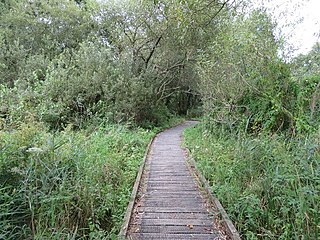
Winnall Moors is a 64-hectare (160-acre) nature reserve in Winchester in Hampshire. It is managed by the Hampshire and Isle of Wight Wildlife Trust.
Witton-le-Wear (SSSI) is a Site of Special Scientific Interest located in the valley of the River Wear, immediately east of the village of Witton-le-Wear in County Durham, England.
Westernhope Burn Wood is a Site of Special Scientific Interest in the Wear Valley district of south-west County Durham, England. It occupies the steeply-incised ravine of the Westernhope Burn, a tributary of the River Wear, which it joins from the south about halfway between the villages of Eastgate and Westgate.

Cefn Blaenau is a 23-hectare Site of Special Scientific Interest in a small upland valley in Carmarthen and Dinefwr, Wales. It was designated an SSSI in 1989, primarily for its flush and spring vegetation as well as the diverse mosaic of unimproved pasture, ‘ffridd’ land, marshy grassland, wet heath, acid grassland, broadleaved woodland, streams, and small rock outcrops. These habitats, which are well represented at this site, have been greatly reduced in north Carmarthenshire due to land improvement, agricultural intensification, and afforestation. Only about 140 hectares of flush and spring vegetation remain in the county.

Range Farm Fields is a 12.8-hectare (32-acre) biological Site of Special Scientific Interest in Gloucestershire, near to Gloucester City, notified in 1996.
Shorn Cliff And Caswell Woods is a 69.2-hectare (171-acre) biological Site of Special Scientific Interest in Gloucestershire, notified in 1986. The site is listed in the 'Forest of Dean Local Plan Review' as a Key Wildlife Site (KWS).

The Hudnalls is a 94.4-hectare (233-acre) biological Site of Special Scientific Interest in Gloucestershire, notified in 1972. The site is listed in the 'Forest of Dean Local Plan Review' as a Key Wildlife Site (KWS).

Allendale Moors is a Site of Special Scientific Interest (SSSI) in Northumberland, England. The upland moorland ridge site is listed for its heath, flush and upland grassland which provide a habitat for a nationally important assemblage of moorland breeding birds.

Bewick and Beanley Moors is the name given to a Site of Special Scientific Interest (SSSI) in north Northumberland, in the north-east of England. The moors are asserted to be of national importance by Natural England for the extent, quality and diversity of upland types including heaths, fens, wet grassland, flushes, mires and blanket bogs, together creating an extensive mosaic habitat supporting an exceptional community of amphibians. The moors are important, too, for their relict juniper woodland and scrub.

King's Copse is a 13.7-hectare (34-acre) biological Site of Special Scientific Interest between Chapel Row and Clay Hill in Berkshire. It is in the North Wessex Downs, which is an Area of Outstanding Natural Beauty. The site is private land but a public footpath runs through it.

Enborne Copse is a 11.9-hectare (29-acre) biological Site of Special Scientific Interest west of Newbury in Berkshire. It is a Nature Conservation Review site.
Fallowlees Flush is the name given to a Site of Special Scientific Interest (SSSI) in mid-Northumberland, England. The steeply sloping site has calcium-rich springs supporting vegetation rare in the county.

Mar Field Fen is a Site of Special Scientific Interest, or SSSI, north of Masham, North Yorkshire, England, in a rural area known as Marfield. It is situated on land containing woodland carr, fen, spring-fed marshy grassland and drier calcareous grassland, between the River Ure to the east and Marfield Wetland nature reserve to the west. As "one of the best examples of fen habitat in the Vale of York," it is a protected habitat for a variety of plants, including the common butterwort, a carnivorous plant. There is no public access to this site.


