
Fairmile Bottom is a 70.2-hectare (173-acre) biological Site of Special Scientific Interest north-west of Arundel in West Sussex. An area of 61.3 hectares is also a Local Nature Reserve.

Harting Downs is a 336.3-hectare (831-acre) biological Site of Special Scientific Interest west of Midhurst in West Sussex. It is a Nature Conservation Review site, Grade I and an area of 206.6 hectares is a Local Nature Reserve which is owned and managed by the National Trust.

Watlington and Pyrton Hills is a 112.7-hectare (278-acre) biological Site of Special Scientific Interest east of Watlington in Oxfordshire. An area of 1.6 hectares is Watlington Chalk Pit, which is a Local Nature Reserve.
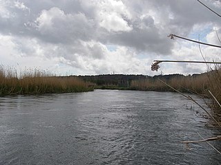
Avon Valley is a 1,403.8-hectare (3,469-acre) biological Site of Special Scientific Interest which stretches from Christchurch in Dorset to Bickton, south of Fordingbridge Hampshire. It is a Nature Conservation Review site, a Ramsar site, a Special Area of Conservation and a Special Protection Area. An area of 159 hectares is Blashford Lakes, a nature reserve managed by the Hampshire and Isle of Wight Wildlife Trust,

Broughton Down is a 45.8-hectare (113-acre) biological Site of Special Scientific Interest west of Broughton in Hampshire. The eastern half is a nature reserve managed by the Hampshire and Isle of Wight Wildlife Trust

Coulters Dean is a 2.2-hectare (5.4-acre) biological Site of Special Scientific Interest south-east of Buriton in Hampshire. It is part of the 4-hectare (9.9-acre) Coulters Dean nature reserve, which is managed by the Hampshire and Isle of Wight Wildlife Trust.

Crab Wood is a 73-hectare (180-acre) biological Site of Special Scientific Interest west of Winchester in Hampshire. An area of 37.8 hectares is also a Local Nature Reserve.
Danebury Hill is a 13.7-hectare (34-acre) biological Site of Special Scientific Interest north-east of Nether Wallop in Hampshire. It is part of Danebury Hillfort Local Nature Reserve.

Hythe to Calshot Marshes is a 591.8-hectare (1,462-acre) biological Site of Special Scientific Interest which stretches along the west bank of Southampton Water between Calshot and Marchwood in Hampshire. It is part of Solent and Southampton Water Ramsar site and Special Protection Area, and of Solent Maritime Special Area of Conservation. Calshot Marshes is a Local Nature Reserve and Hythe Spartina Marsh is a nature reserve managed by the Hampshire and Isle of Wight Wildlife Trust.

Lee-on-The Solent to Itchen Estuary is a 585.9-hectare (1,448-acre) biological and geological Site of Special Scientific Interest which stretches along the coast between Southampton and Gosport in Hampshire. It is a Geological Conservation Review site. It is part of Solent and Southampton Water Ramsar site and Special Protection Area, and of Solent Maritime Special Area of Conservation. Three areas are Local Nature Reserves, Chessel Bay, Hook with Warsash and Mercury Marshes. One area is Hamble Common Camp, a Scheduled Monument.
Lincegrove and Hackett's Marshes is a 37.8-hectare (93-acre) biological Site of Special Scientific Interest on the west bank of the River Hamble between Southampton and Fareham in Hampshire. It is part of Solent and Southampton Water Ramsar site and Special Protection Area, and of Solent Maritime Special Area of Conservation. Hackett's Marsh is a 20.4 hectares Local Nature Reserve.

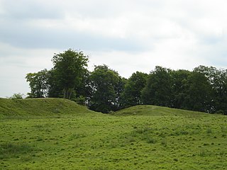
Martin and Tidpit Downs is a 367.5-hectare (908-acre) biological Site of Special Scientific Interest north-west of Fordingbridge in Hampshire. Martin Down is a 341-hectare (840-acre) national nature reserve and an area of 115 hectares is a Nature Conservation Review site, Grade I. Bokerley Dyke, a prehistoric linear earthwork and scheduled monument, runs through the site.

Wealden Edge Hangers is a 222.4-hectare (550-acre) biological Site of Special Scientific Interest north of Petersfield in Hampshire. An area of 48 hectares is Wealden Edge Hangers Local Nature Reserve and an area of 144.1 hectares is Ashford Hangers National Nature Reserve. Wealden Edge Hangers is part of the East Hampshire Hangers Special Area of Conservation.
Oxenbourne Down, Clanfield is a 84.8-hectare (210-acre) Local Nature Reserve north of Clanfield in Hampshire. It is owned and managed by Hampshire County Council. It is part of Butser Hill, which is a Special Area of Conservation and Site of Special Scientific Interest.

Sturt Pond is a 10.9-hectare (27-acre) Local Nature Reserve in Milford on Sea in Hampshire. It is owned and managed by Milford On Sea Parish Council. It is part of Solent and Southampton Water Ramsar site and Special Protection Area, of Solent Maritime Special Area of Conservation and of Hurst Castle and Lymington River Estuary, which is a Site of Special Scientific Interest.
