The North Wessex Downs are an area of chalk downland landscapes located in the English counties of Berkshire, Hampshire, Oxfordshire and Wiltshire. The North Wessex Downs has been designated as a National Landscape since 1972.

Combe is a village and civil parish in the English county of Berkshire. The parish is situated on the top of the North Hampshire Downs near Walbury Hill and Combe Gibbet, overlooking the village of Inkpen and the valley of the River Kennet. In Walbury Hill, it includes the highest natural point in South East England.

East Woodhay is a village and civil parish in Hampshire, England. The village is approximately 5.5 miles (9 km) south-west of Newbury in Berkshire. At the 2011 census the parish had a population of 2,914.

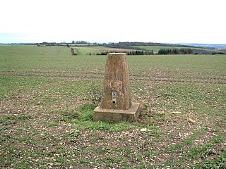
Walbury Hill is a summit of the North Wessex Downs in Berkshire, England. With an elevation of 297 metres (974 ft), it is the highest natural point in South East England. On the hill's summit is the Iron Age hill fort of Walbury Camp, whilst the flanks of the hill lie within the Inkpen and Walbury Hills SSSI. The hill is one of three nationally important chalk wild grasslands in the North Wessex Downs, the others being in the Rushmore and Conholt Downs SSSI and the Hog's Hole SSSI. The summit of the hill is marked by a triangulation pillar, but lies on private land with no public access, although public access is available to the north of the summit via a byway.

Beech Hill is a small village and civil parish in Berkshire, England. It is in the south east of the West Berkshire unitary authority area and bounds Hampshire and Wokingham district.

Upper Lambourn is a small village in the county of Berkshire, England. The village is situated in the civil parish of Lambourn, and is 1.2 miles (2 km) to the north-west of the village of Lambourn, just off the Lambourn to Shrivenham road. The parish is within the district of West Berkshire, close to the point where the counties of Berkshire, Oxfordshire and Wiltshire meet.

Hamstead Marshall is a village and civil parish in the English county of Berkshire. The village is located within the North Wessex Downs. The population of this civil parish at the 2011 census was 275.

Beacon Hill is near the village of Burghclere and Watership Down, in north Hampshire. The hill's name is derived from the fact that it was one of many Beacon Hills in England and beyond. This hill was once the site of the most famous beacon in Hampshire. It is 261 metres high and has one of England's most well known hill forts on its slopes, visible from the main A34 road which passes close by. From there, outstanding views of the surrounding area and much of Hampshire may be obtained. The site is open to the public and managed by Hampshire County Council. It is an 80.7-hectare (199-acre) biological Site of Special Scientific Interest called Burghclere Beacon and a Nature Conservation Review site, Grade I.
Pilot Hill is the highest summit in Hampshire, England, with a maximum elevation of 286 m (938 ft). It lies around 2 miles (3.2 km) to the south-east of Walbury Hill, the county top of Berkshire, which is 297 m (974 ft) high.

Wasing is an agricultural and woodland village, country estate and civil parish in West Berkshire, England owned almost wholly by the descendants of the Mount family. In local administration, its few inhabitants convene their own civil parish, but share many facilities with Brimpton which was in its civil parish at the time of the 2011 Census.

West Woodhay ( "woody") is a rural scattered village and civil parish in West Berkshire, England. At the 2011 census it had 59 households.

Eastbury is a village in the valley of the River Lambourn in the English county of Berkshire. The village is situated on the old river level road from Newbury to Lambourn, and is 1.5 miles (2.4 km) east of Lambourn and 1 mile (1.6 km) west of East Garston. The village is situated in the civil parish of Lambourn, which is within the unitary authority of West Berkshire.
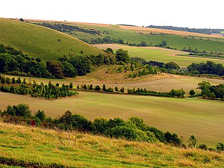
Inkpen Hill is a summit in Berkshire, England, with a maximum elevation of 291 m (955 ft). The hill is about 7 miles (11 km) southwest of Newbury on the Hampshire/Berkshire border and is part of the north-facing scarp of the North Hampshire Downs, a chalk ridge within the North Wessex Downs Area of Outstanding Natural Beauty. It lies between Walbury Hill, the county top of Berkshire, to the east and Ham Hill to the west. Parts of the hill lie within the Inkpen and Walbury Hills SSSI.
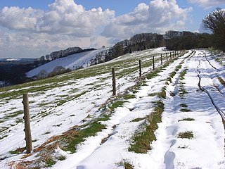
Inkpen and Walbury Hills is an 86.8-hectare (214-acre) biological Site of Special Scientific Interest south of Kintbury in Berkshire. The site is situated on the flanks of Walbury Hill, the highest point in Berkshire and South East England, and the adjacent Inkpen Hill. A Bronze Age cemetery of three bowl barrows on Inkpen Hill is designated a Scheduled Monument.

Greenham and Crookham Commons are two adjoining public park areas of 280.5-hectare (693-acre) common land designated as a biological Site of Special Scientific Interest (SSSI) in the civil parishes of Greenham and Thatcham, on the southern outskirts of Newbury in the English county of Berkshire.

Hog's Hole is a 23.7-hectare (59-acre) biological Site of Special Scientific Interest in the civil parish of Combe in the English county of Berkshire.

Westfield Farm Chalk Bank is a 14.1-hectare (35-acre) biological Site of Special Scientific Interest west of East Garston in Berkshire.

Chawridge Bourne is a 9.4-hectare (23-acre) biological Site of Special Scientific Interest in Berkshire, England Part of the site is a 5-hectare (12-acre) nature reserve called Chawridge Bank, which is managed by the Berkshire, Buckinghamshire and Oxfordshire Wildlife Trust.

Combe Hill is a summit in Berkshire, England, with a maximum elevation of 293 m (961 ft). It lies around 1 mile (1.6 km) to the south-east of Walbury Hill, the county top of Berkshire, which is 297 m (974 ft) high. The hill is about 7 miles (11 km) southwest of Newbury on the Hampshire/Berkshire border and is part of the north-facing scarp of the North Hampshire Downs, a chalk ridge within the North Wessex Downs Area of Outstanding Natural Beauty.