Kent Wildlife Trust (KWT) is a conservation charity in the United Kingdom that was founded in 1958, previously known as the Kent Trust for Nature Conservation. It aims to "work with people to restore, save and improve our natural spaces" and to "ensure that 30% of Kent and Medway – land and sea – is managed to create a healthy place for wildlife to flourish". In 2016 it had thirty-one thousand members and an annual income of £4 million. KWT manages over sixty-five nature reserves, of which twenty-four are Sites of Special Scientific Interest, two are national nature reserves, nine are Nature Conservation Review sites, seven are Special Areas of Conservation, three are Special Protection Areas, seven are local nature reserves, one is a Geological Conservation Review site, thirteen are in Areas of Outstanding Natural Beauty and one is a scheduled monument.
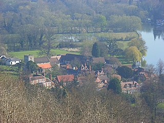
Streatley is a village and civil parish on the River Thames in Berkshire, England. The village faces Goring-on-Thames. The two places share in their shops, services, leisure, sports and much of their transport. Across the river is Goring & Streatley railway station and the village cluster adjoins a lock and weir. The west of the village is a mixture of agriculture and woodland plus a golf course. The village has a riverside hotel. Much of Streatley is at steeply varying elevations, ranging from 51m AOD to 185m at Streatley Warren, a hilltop point on its western border forming the eastern end of the Berkshire Downs. This Area of Outstanding Natural Beauty is topped by the 87-mile The Ridgeway path, which crosses the Thames at Goring and Streatley Bridge.

Lardon Chase, the Holies and Lough Down is a National Trust countryside property in the English county of Berkshire. It is situated on the edge of the Berkshire Downs above the village of Streatley and overlooking the Goring Gap. The property comprises an outstanding area of 27 hectares of downland and woodland with many attractive walks and views. Lardon Chase, and a part of the Holies known as Holies Down, are also designated as Sites of Special Scientific Interest. The property lies within the North Wessex Downs Area of Outstanding Natural Beauty, and in an area known for the presence of several Neolithic and Iron Age forts.

The Berkshire, Buckinghamshire and Oxfordshire Wildlife Trust (BBOWT), is a wildlife trust covering the counties of Berkshire, Buckinghamshire and Oxfordshire in England.

Whitehorse Hill is a hill in the Berkshire Downs in Oxfordshire, England, west of Wantage. At 261 metres (856 ft), it is the highest point in Oxfordshire. Uffington Castle lies on the summit of the hill, and the Uffington White Horse is on the hill's northern slope. The hill and an adjacent area below, including Dragon Hill and The Manger, make up a 98.9-hectare (244-acre) biological and geological Site of Special Scientific Interest.

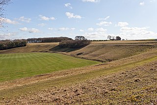
Lardon Chase is a 14.9-hectare (37-acre) biological Site of Special Scientific Interest in Streatley in Berkshire. It is in the North Wessex Downs, which is an Area of Outstanding Natural Beauty, and is part of the Lardon Chase, the Holies and Lough Down National Trust property.

Bowerchalke Downs, is a 134 hectares biological Site of Special Scientific Interest in southern Wiltshire, England, notified in 1971.

Pewsey Downs is a 305.3 hectare biological Site of Special Scientific Interest on the southern edge of the Marlborough Downs north of Pewsey in Wiltshire, notified in 1951. It includes the Pewsey Downs National Nature Reserve.

Park Gate Down or Parkgate Down is a 7-hectare (17-acre) biological Site of Special Scientific Interest south-east of Stelling Minnis in Kent. It is also a Special Area of Conservation and is managed by the Kent Wildlife Trust,

Hollingbourne Downs is a 60.9-hectare (150-acre) biological Site of Special Scientific Interest east of Maidstone in Kent.

Quarry Hangers is a 28.5-hectare (70-acre) biological Site of Special Scientific Interest south-west of Caterham in Surrey. An area of 11 hectares is a nature reserve managed by the Surrey Wildlife Trust.

Woldingham and Oxted Downs is a 128.4-hectare (317-acre) biological Site of Special Scientific Interest east of Caterham in Surrey.
Cheesefoot Head is a large natural amphitheatre and beauty spot just outside Winchester, England. It is situated on the A272 road. There are three bowl barrows on the site. The east, south and west walls of the amphitheatre are a 13.4-hectare (33-acre) biological Site of Special Scientific Interest (SSSI).

Willingdon Down is a 67.5-hectare (167-acre) biological Site of Special Scientific Interest west of Willingdon, a suburb of Eastbourne in East Sussex. Part of it is a Neolithic causewayed enclosure which is a Scheduled Monument

Hackpen, Warren & Gramp's Hill Downs is a 71.4-hectare (176-acre) biological Site of Special Scientific Interest in Letcombe Bassett in Oxfordshire.

Streatley Warren is a 31.3-hectare (77-acre) biological Site of Special Scientific Interest west of Streatley in Berkshire. It is in the North Wessex Downs, which is an Area of Outstanding Natural Beauty.

Fames Rough is a 23-hectare (57-acre) nature reserve south-west of Chipstead in Surrey. It is managed by the Surrey Wildlife Trust and is part of the Chipstead Downs Site of Special Scientific Interest.

West Harting Down SSSI is a 13.9-hectare (34-acre) biological Site of Special Scientific Interest west of South Harting in West Sussex. It is part of the 317.9-hectare (786-acre) West Harting Down, which is managed by Forestry England.