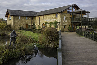
WWT London Wetland Centre is a wetland reserve managed by the Wildfowl and Wetlands Trust in the Barnes area of the London Borough of Richmond upon Thames, southwest London, England, by Barn Elms. The site is formed of four disused Victorian reservoirs tucked into a loop in the Thames.

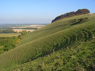
Beacon Hill is near the village of Burghclere and Watership Down, in north Hampshire. The hill's name is derived from the fact that it was one of many Beacon Hills in England and beyond. This hill was once the site of the most famous beacon in Hampshire. It is 261 metres high and has one of England's most well known hill forts on its slopes, visible from the main A34 road which passes close by. From there, outstanding views of the surrounding area and much of Hampshire may be obtained. The site is open to the public and managed by Hampshire County Council. It is an 80.7-hectare (199-acre) biological Site of Special Scientific Interest called Burghclere Beacon and a Nature Conservation Review site, Grade I.

Lardon Chase is a 14.9-hectare (37-acre) biological Site of Special Scientific Interest near Streatley in Berkshire. Bordering Oxfordshire, It is in the North Wessex Downs, which is an Area of Outstanding Natural Beauty, and is part of the Lardon Chase, the Holies and Lough Down National Trust property.

Pewsey Downs is a 305.3 hectare biological Site of Special Scientific Interest on the southern edge of the Marlborough Downs north of Pewsey in Wiltshire, notified in 1951. It includes the Pewsey Downs National Nature Reserve.
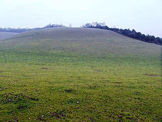
Ham Hill is a hill and area of chalk downland in Wiltshire, England, on the steep banks running alongside the road from the village of Ham to Buttermere, close to the Berkshire border. A biological Site of Special Scientific Interest, notified in 1971, covers 1.5 hectares of the site; this designation is due to the site's species-rich plant and insect communities, which include some rare species. Notable among these is the musk orchid, which has been confirmed at only one other site in Wiltshire.
Holies Down is a 5.6-hectare (14-acre) biological Site of Special Scientific Interest south of Streatley in Berkshire. It is in the North Wessex Downs, which is an Area of Outstanding Natural Beauty, and is part of the Holies section of the Lardon Chase, the Holies and Lough Down National Trust property.

Holme Fen is a 269.4-hectare (666-acre) biological Site of Special Scientific Interest near Holme in Cambridgeshire. It is also a National Nature Reserve and a Nature Conservation Review site, Grade I. It is part of the Great Fen project, which aims to create a 3,700-hectare wetland wildlife area including Holme Fen, Woodwalton Fen and other areas. It is home to a variety of birds, including the Eurasian siskin, Nightingale and Lesser redpoll, and around 450 species of fungi.

Tunstall Hills is an area of open space in Sunderland, Tyne and Wear, England. It is a Local Nature Reserve and Tunstall Hills And Ryhope Cutting has been designated a Site of Special Scientific Interest both for its geological and biological importance. The area consists of Green Hill and Rocky Hill and surrounding land.
Hayes Common is a 79-Hectare area of public open land in Hayes in the London Borough of Bromley. It is owned and managed by Bromley Council. It is Site of Metropolitan Importance for Nature Conservation, and a small area is part of the Keston and Hayes Commons Site of Special Scientific Interest. The common is an area of woodland and heath, crossed by bridleways and footpaths. Hayes Common is one of the largest areas of common land in Greater London, with 91.1 hectares of protected commons.

Englemere Pond is a 26.1-hectare (64-acre) biological Site of Special Scientific Interest on the southern outskirts of North Ascot in Berkshire. The site is also a Local Nature Reserve. It is owned by the Crown Estate and managed by Bracknell Forest Borough Council.

Hog's Hole is a 23.7-hectare (59-acre) biological Site of Special Scientific Interest in the civil parish of Combe in the English county of Berkshire.

Gentianella anglica, the early gentian, is a species of flowering plant in the genus Gentianella, native to Great Britain. Gentianella anglica is endemic to Great Britain and its centre of distribution is in Dorset, Wiltshire, and the Isle of Wight.
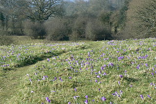
Inkpen Crocus Fields is a 3.1-hectare (7.7-acre) biological Site of Special Scientific Interest near Inkpen in Berkshire. It is managed by the Berkshire, Buckinghamshire and Oxfordshire Wildlife Trust.

West's Meadow, Aldermaston is a 1.2-hectare (3.0-acre) biological Site of Special Scientific Interest south of Aldermaston in Berkshire.

Cleeve Hill is a 4-hectare (9.9-acre) biological Site of Special Scientific Interest south of Lambourn in Berkshire.

Chawridge Bourne is a 9.4-hectare (23-acre) biological Site of Special Scientific Interest in Berkshire, England Part of the site is a 5-hectare (12-acre) nature reserve called Chawridge Bank, which is managed by the Berkshire, Buckinghamshire and Oxfordshire Wildlife Trust.

Wraysbury and Hythe End Gravel Pits is a 117.2-hectare (290-acre) biological Site of Special Scientific Interest in Wraysbury in Berkshire. It is part of South West London Waterbodies Ramsar site and Special Protection Area.

Watts Bank is a 1.9-hectare (4.7-acre) nature reserve south of Lambourn in Berkshire. It is managed by the Berkshire, Buckinghamshire and Oxfordshire Wildlife Trust. It is designated a biological Site of Special Scientific Interest as White Shute.
Lakenheath Warren is a 588.3-hectare (1,454-acre) biological Site of Special Scientific Interest south-east of Lakenheath in Suffolk, England. It is a Nature Conservation Review site, Grade I, and part of Breckland Special Area of Conservation and Breckland Special Protection Area under the European Union Directive on the Conservation of Wild Birds. The RAF Lakenheath base is located nearby.