Kintbury is a village and civil parish in Berkshire, England, between the towns of Newbury and Hungerford. The village has a convenient railway to Paddington and Reading, proximity to other transport and local cultural destinations, including Roman and Norman sites, and forms part of a very large Area of Outstanding Natural Beauty, the North Wessex Downs which extends from the River Thames at Streatley to West Wiltshire.
The Goring Gap is the narrow valley, occupied by the River Thames, between the Chiltern Hills and the Berkshire Downs. It is approximately 10 miles (16 km) upstream of Reading and 27 miles (43 km) downstream of Oxford. The river here delimits Berkshire from Oxfordshire. The village of Goring, on the Oxfordshire side of the Thames, gives its name to the gap.
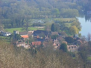
Streatley is a village and civil parish on the River Thames in Berkshire, England. The village faces Goring-on-Thames. The two places share in their shops, services, leisure, sports and much of their transport. Across the river is Goring & Streatley railway station and the village cluster adjoins a lock and weir. The west of the village is a mixture of agriculture and woodland plus a golf course. The village has a riverside hotel. Much of Streatley is at steeply varying elevations, ranging from 51m AOD to 185m at Streatley Warren, a hilltop point on its western border forming the eastern end of the Berkshire Downs. This Area of Outstanding Natural Beauty is topped by the 87-mile The Ridgeway path, which crosses the Thames at Goring and Streatley Bridge.

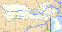
The North Wessex Downs Area of Outstanding Natural Beauty (AONB) is located in the English counties of Berkshire, Hampshire, Oxfordshire and Wiltshire. The name North Wessex Downs is not a traditional one, the area covered being better known by various overlapping local names, including the Berkshire Downs, the North Hampshire Downs, the White Horse Hills, the Lambourn Downs, the Marlborough Downs, the Vale of Pewsey and Savernake Forest.

Lardon Chase, the Holies and Lough Down is a National Trust countryside property in the English county of Berkshire. It is situated on the edge of the Berkshire Downs above the village of Streatley and overlooking the Goring Gap. The property comprises an outstanding area of 27 hectares of downland and woodland with many attractive walks and views. Lardon Chase, and a part of the Holies known as Holies Down, are also designated as Sites of Special Scientific Interest. The property lies within the North Wessex Downs Area of Outstanding Natural Beauty, and in an area known for the presence of several Neolithic and Iron Age forts.

The Berkshire, Buckinghamshire and Oxfordshire Wildlife Trust (BBOWT), is a wildlife trust covering the counties of Berkshire, Buckinghamshire and Oxfordshire in England.

Seven Barrows is a Bronze Age bowl barrow cemetery, 4-hectare (9.9-acre) of which are designated a biological Site of Special Scientific Interest, at Upper Lambourn in the civil parish of Lambourn in the English county of Berkshire. It is managed by the Berkshire, Buckinghamshire and Oxfordshire Wildlife Trust and it is a Scheduled Monument.

Freeman's Marsh is a 25.1-hectare (62-acre) biological Site of Special Scientific Interest on the northern outskirts of Hungerford in Berkshire. It is in the North Wessex Downs, which is an Area of Outstanding Natural Beauty. The site is owned by the Town and Manor of Hungerford.
Holies Down is a 5.6-hectare (14-acre) biological Site of Special Scientific Interest south of Streatley in Berkshire. It is in the North Wessex Downs, which is an Area of Outstanding Natural Beauty, and is part of the Holies section of the Lardon Chase, the Holies and Lough Down National Trust property.

Sulham and Tidmarsh Woods and Meadows is a 75.7-hectare (187-acre) biological Site of Special Scientific Interest west of Reading in Berkshire. Previously known as Pang Valley SSSI, the site is mostly sandwiched between the River Pang and the Sulham Road and includes Broom Copse, Herridge's Copse, Hogmoor Copse, Park Wood, Moor Copse and Barton's Copse. Much of the southern part of the site is the Berkshire, Buckinghamshire and Oxfordshire Wildlife Trust's Moor Copse Nature Reserve. The whole site lies within the North Wessex Downs Area of Outstanding Natural Beauty.

Longmoor Bog is a 14-hectare (35-acre) biological Site of Special Scientific Interest north of Finchampstead in Berkshire. An area of 11.8 hectares is a Local Nature Reserve. It is part of California Country Park, which is owned and managed by Wokingham District Council.

Hackpen, Warren & Gramp's Hill Downs is a 71.4-hectare (176-acre) biological Site of Special Scientific Interest in Letcombe Bassett in Oxfordshire.

Moulsford Downs is a 13.6-hectare (34-acre) biological Site of Special Scientific Interest north-west of Goring-on-Thames in Oxfordshire.

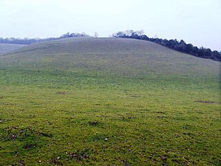
Streatley Warren is a 31.3-hectare (77-acre) biological Site of Special Scientific Interest west of Streatley in Berkshire. It is in the North Wessex Downs, which is an Area of Outstanding Natural Beauty.

Fognam Chalk Quarry is a 3-hectare (7.4-acre) geological Site of Special Scientific Interest west of Upper Lambourn in Berkshire. It is a Geological Conservation Review site. It is in the North Wessex Downs.

Park Farm Down or Parkfarm Down is a 3.3-hectare (8.2-acre) biological Site of Special Scientific Interest north-west of Lambourn in Berkshire. It is in the North Wessex Downs, which is an Area of Outstanding Natural Beauty.

Rack Marsh is a 4-hectare (9.9-acre) nature reserve in Bagnor, on the north-western outskirts of Newbury in Berkshire. It is managed by the Berkshire, Buckinghamshire and Oxfordshire Wildlife Trust. It is part of Kennet and Lambourn Floodplain, which is a Biological Site of Special Scientific Interest, and a Nature Conservation Review site. It is also part of the Kennet and Lambourn Floodplain Special Area of Conservation.